Cabras Islets
| Cabras Islet (Ilhéus das Cabras) | |
| Islets of Goats | |
| Islets (Ilhéus) | |
 The profile of the cone that formed the islets, comprising the Ilhéu Grande (Large Islet), on the left, and the Ilhéu Pequeno (Small Islet), to the right | |
| Official name: O Ilhéu das Cabras | |
| Named for: (Portuguese) goats, that were historically deposited on the islets during the year by shepards to forage | |
| Nickname: As Cabras | |
| Country | Portugal |
|---|---|
| Autonomous region | Azores |
| Islands | Central Group |
| Location | Azores Platform, Mid-Atlantic Ridge, Atlantic Ocean |
| Civil parish | Porto Judeu |
| Municipality | Angra do Heroísmo |
| Highest point | |
| - location | Cabras Islets, Porto Judeu, Angra do Heroísmo |
| - elevation | 22 m (72 ft) |
| - coordinates | 38°37′49.03″N 27°8′36.33″W / 38.6302861°N 27.1434250°W |
| Lowest point | Sea level |
| - location | Atlantic Ocean, Porto Judeu, Angra do Heroísmo |
| - elevation | 0 m (0 ft) |
| Area | .2814 km2 (0 sq mi) |
| Biome | Marine |
| Geology | Basalt |
| Orogeny | Volcanism |
| Period | Holocene |
| Protection | Special Protection Area Ilhéu das Cabras (PTZPE0032) |
 Location of the island of Terceira in the archipelago of the Azores
| |
 Location of the islets off the coast of Terceira
| |
The Cabras Islet (Portuguese: Ilhéus das Cabras) is a dual islet, along the southern coast of the island of Terceira in the Portuguese archipelago of the Azores. The group, with a total area of 29 hectares (72 acres) and perimeter of 3,239 metres (10,627 ft), is the largest islet in the Azores, normally referred to as a single islet (Portuguese: O Ilhéu das Cabras) by locals, but comprising two landforms: the Ilhéu Pequeno (Small Islet) and the Ilhéu Grande (Large Islet).[1]
History
Although uninhabited, the islets were used by shepherds, who foraged their goats and sheep on the islets throughout the year during early settlement of the archipelago.[1] Legend also recounts that, for seven years, a young Faialense with a capricious heart was exiled to the islet by the father of his beloved maiden.[1]
A reference in the south part of the island of Terceira, there are still some who referred to the time when a German submarine remained hidden in the waters around the islet during World War Two, and from that point it conducted its attacks.[1]
From the earliest settlement of the archipelago, the islet was embroiled in controversy associated with their ownership. In 1666, the islets were part of the property of Braz Pires do Canto, son of Sebastião Martins do Canto. Two hundred and six years later, on 26 February 1872, the islets were registered in the name of Miguel do Canto e Castro Pacheco de Sampaio, a descendent of Braz Pires. Miguel do Canto was a Peer of the Realm, and lived in Lisbon, relying on the representation of his aunt, Margarida Cândida do Canto, a resident of Angra do Heroísmo. The registry was justified, owing to the islets having been successively a property of the family. Ownership later transferred to José Francisco do Canto's grandfather, Miguel do Canto e Castro Pacheco de Sampaio.[2]
On 11 February 1905, they again changed ownership, becoming the property of Dr. Eduardo Abreu, medic, and his wife Adelaide de Brito do Rio Abreu, landowner and resident of the city of Amares, as part of the legacy of D. Maria Luísa do Canto e Castro da Silva Ataíde, who willed it to him (approved 3 November 1888). Their son, Henrique Abreu, then a resident of Braga, transferred the lands into his name on 26 September 1910.[3]
Today, the islets remain the private property of the descendents of the family of José Luís Evangelho.
Vitorino Nemésio referred to the islets as "a estátua da nossa solidão" ("the statute of our solitude") in his book Corsário das Ilhas (1956).
In 2011, the ZPE was formally integrated into the Nature Park of Terceira, that included the entirety of the ZPE (Special Protection Area) that encompassed the islets, and the waters around them:[4][5]
- [TER07] Área Protegida dos Ilhéus das Cabras, that included all the land above sea level, encompassing the cliffs and landsforms;[6]
- [TER17] Área Marinha Protegida dos Ilhéus das Cabras[5]
Underwriting this classification was the necessity to protect marine wildlife, specifically marine birds, that were nesting the cliffs and rocky outcrops of the landforms.[5]
Geography


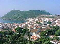
The Islets of Goats is located in the southeast coast, east of Angra do Heroísmo, and conforms to the civil parish of Porto Judeu. They are volcanic islets, the remains of a cinder cone eroded by the sea, and fortified by tectonic palagonite forces.
Resulting from the remains of the submerse volcano, that originated them, the symmetrical cone inspired Vitorino Nemésio to characterize the islets as "broken in half, like a badly formed".[1]
Biome
The difficult access and rocky cliffs makes this area an ideal location for a significant population of Cory's shearwater (Calonectris diomedea borealis) and the common tern (Sterna hirundo), that annually migrate through the Azores to nest, in addition to capped heron (Arrfea cinerea), the sanderling (Calidris alba), the Kentish plover (Charadrius alexandrinus) and other marine birds such as seagulls.[1] The presence of these birds, protected by Annex I of the Habitats Directive, resulted in the islets' reclassification as a Zona de Protecção Especial (Special Protection Zone), warranting its inclusion within the listing of Important Bird Areas (Portuguese: Zonas Importantes para as Aves) in the Azores (published by BirdLife International).[1][7]
The Azorean bat (Nyctalus azorium), which also finds protection on the islets, is an endemic mammal to the Azores, and the smallest European bat species.[1] This species is threatened, and therefore, protected by the Bern Convention and Habitats Directive, as evaluated by the International Union for Conservation of Nature.[1]
There are various grottoes, caves and niches, formed by the its volcanic history, resulting in diverse and unique biotopes.[1] The Ratões Grotto (Portuguese: Gruta dos Ratões) along the northern coast of western islet, is recognized by divers, as one of the few places in the Azores destined for a large reproductive mass of eagle rays (Myliobatis aquila).[1]
The biological diversity and geographical conditions makes the area around the Cabras ideal for sub-aquatic activities, that includes recreational and scientific investigations.[1] The area is also the location of various fish species, as well as other marine vertebrates and invertebrates, frequented by cetaceans, such as the common bottlenose dolphin (Tursiops truncatus) and turtles, like the loggerhead sea turtle (Caretta caretta) (species also covered under Annex II of the Habitats Directive within the European Union).[1]
References
- Notes
- 1 2 3 4 5 6 7 8 9 10 11 12 13 Toste, Sandra (September 2010), Ilhéus das Cabras (PDF) (in Portuguese), Ponta Delgada (Azores), Portugal: SRAM Secretária Regional do Ambiente e do Mar, retrieved 15 November 2012
- ↑ Lisbon District Land Registry Office (5 March 1873), Book F5, No. 2146, pp. 20
- ↑ Braga Land Registry Office, Book F19, No. 9391, p. 145
- ↑ DRE (20 April 2011), p. 2361–2362
- 1 2 3 DRE (20 April 2011), p.2365
- ↑ DRE (20 April 2011), p. 2371
- ↑ Meirinho et al. (2004)
- Sources
- Meirinho, A.; Magalhães, M.C.; Pitta Groz, M. (2004), Proposta de Plano de Gestão para a Zona de Protecção Especial Ilhéu das Cabras (PDF) (in Portuguese), Série Estudos (8/2004), Departmente de Pescas (DOP), p. 37
- Ricardo Serrão Santos, ed. (June 2004), Proposta de Plano de Gestão para a Zona de Protecção Especial Ilheus das Cabras (PDF) (in Portuguese), Faial (Azores), Portugal: IMAR Instituto do Mar/Departamento de Oceanografica e Pescas/University of the Azores
- DRE, ed. (20 April 2011), Decreto Legislativo Regional nº.11/2011/A: Cria o Parque Natural da Terceira (PDF) (in Portuguese), Série I, No.78, Diário da República, p. 2355, retrieved 6 October 2012