CC Road
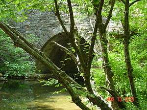
During the Great Depression the Civilian Conservation Corps constructed a road to the ridge of Cheaha Mountain, the highest point in Alabama. The local name for the road is now official, the "CC Road" with one of the Cs of the Civilian Conservation Corps having been lost over the years in local usage. The Road contains ruins of stone arches and bridges in good condition. It has been closed for at least 18 years, and probably longer, by the National Forest Service. The lower end of the road is still open, and contains a few arches built during the Depression. The closed section of the CC Road is around a six mile walk, although only a little over two miles of linear distance (as the crow flies). A large native stone bridge in the closed section crosses Hillabee Creek, which provides drinking water to Oxford and Anniston.
A link to 1937 U.S.Government film including building of the CC Road, referred to as the Cheaha Road appears at the page on the CCC.