CBD and South East Light Rail
| CBD and South East Light Rail | |||||||||||||||||||||||||||||||||||||||||||||||||||||||||||||||||||||||||||||||||||||||||||||||||||||||||||||||||||||||||||||||||||||||||||||||||||||||||||||||||||||||||||||||||
|---|---|---|---|---|---|---|---|---|---|---|---|---|---|---|---|---|---|---|---|---|---|---|---|---|---|---|---|---|---|---|---|---|---|---|---|---|---|---|---|---|---|---|---|---|---|---|---|---|---|---|---|---|---|---|---|---|---|---|---|---|---|---|---|---|---|---|---|---|---|---|---|---|---|---|---|---|---|---|---|---|---|---|---|---|---|---|---|---|---|---|---|---|---|---|---|---|---|---|---|---|---|---|---|---|---|---|---|---|---|---|---|---|---|---|---|---|---|---|---|---|---|---|---|---|---|---|---|---|---|---|---|---|---|---|---|---|---|---|---|---|---|---|---|---|---|---|---|---|---|---|---|---|---|---|---|---|---|---|---|---|---|---|---|---|---|---|---|---|---|---|---|---|---|---|---|---|---|
|
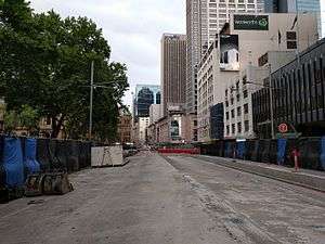
View up George Street from opposite St Andrew's Cathedral in November 2016 | |||||||||||||||||||||||||||||||||||||||||||||||||||||||||||||||||||||||||||||||||||||||||||||||||||||||||||||||||||||||||||||||||||||||||||||||||||||||||||||||||||||||||||||||||
| Overview | |||||||||||||||||||||||||||||||||||||||||||||||||||||||||||||||||||||||||||||||||||||||||||||||||||||||||||||||||||||||||||||||||||||||||||||||||||||||||||||||||||||||||||||||||
| Status | Under construction | ||||||||||||||||||||||||||||||||||||||||||||||||||||||||||||||||||||||||||||||||||||||||||||||||||||||||||||||||||||||||||||||||||||||||||||||||||||||||||||||||||||||||||||||||
| Termini |
Circular Quay Kingsford, Randwick | ||||||||||||||||||||||||||||||||||||||||||||||||||||||||||||||||||||||||||||||||||||||||||||||||||||||||||||||||||||||||||||||||||||||||||||||||||||||||||||||||||||||||||||||||
| Stations | 19 | ||||||||||||||||||||||||||||||||||||||||||||||||||||||||||||||||||||||||||||||||||||||||||||||||||||||||||||||||||||||||||||||||||||||||||||||||||||||||||||||||||||||||||||||||
| Operation | |||||||||||||||||||||||||||||||||||||||||||||||||||||||||||||||||||||||||||||||||||||||||||||||||||||||||||||||||||||||||||||||||||||||||||||||||||||||||||||||||||||||||||||||||
| Opened | 2019 | ||||||||||||||||||||||||||||||||||||||||||||||||||||||||||||||||||||||||||||||||||||||||||||||||||||||||||||||||||||||||||||||||||||||||||||||||||||||||||||||||||||||||||||||||
| Owner | Transport for New South Wales | ||||||||||||||||||||||||||||||||||||||||||||||||||||||||||||||||||||||||||||||||||||||||||||||||||||||||||||||||||||||||||||||||||||||||||||||||||||||||||||||||||||||||||||||||
| Operator(s) | Transdev Sydney | ||||||||||||||||||||||||||||||||||||||||||||||||||||||||||||||||||||||||||||||||||||||||||||||||||||||||||||||||||||||||||||||||||||||||||||||||||||||||||||||||||||||||||||||||
| Depot(s) |
Lilyfield Randwick | ||||||||||||||||||||||||||||||||||||||||||||||||||||||||||||||||||||||||||||||||||||||||||||||||||||||||||||||||||||||||||||||||||||||||||||||||||||||||||||||||||||||||||||||||
| Rolling stock | 30 Alstom Citadis X05s | ||||||||||||||||||||||||||||||||||||||||||||||||||||||||||||||||||||||||||||||||||||||||||||||||||||||||||||||||||||||||||||||||||||||||||||||||||||||||||||||||||||||||||||||||
| Technical | |||||||||||||||||||||||||||||||||||||||||||||||||||||||||||||||||||||||||||||||||||||||||||||||||||||||||||||||||||||||||||||||||||||||||||||||||||||||||||||||||||||||||||||||||
| Track length | 12 km (7.5 mi) | ||||||||||||||||||||||||||||||||||||||||||||||||||||||||||||||||||||||||||||||||||||||||||||||||||||||||||||||||||||||||||||||||||||||||||||||||||||||||||||||||||||||||||||||||
| Track gauge | 1,435 mm (4 ft 8 1⁄2 in) standard gauge | ||||||||||||||||||||||||||||||||||||||||||||||||||||||||||||||||||||||||||||||||||||||||||||||||||||||||||||||||||||||||||||||||||||||||||||||||||||||||||||||||||||||||||||||||
| |||||||||||||||||||||||||||||||||||||||||||||||||||||||||||||||||||||||||||||||||||||||||||||||||||||||||||||||||||||||||||||||||||||||||||||||||||||||||||||||||||||||||||||||||
The CBD and South East Light Rail is a future Australian light rail line in Sydney, New South Wales, running from Circular Quay at the northern end of the Central Business District to the south-eastern suburbs of Randwick and Kingsford. The line will be part of Sydney's light rail network. Major construction commenced in October 2015. The project is being managed by Transport for NSW, a statutory authority of the New South Wales Government. Construction, operation and maintenance of the line is contracted to the ALTRAC Light Rail consortium.
Background and initial announcement
Since the light rail network's original line opened in 1997, a line through the Sydney central business district had been suggested numerous times but failed to achieve State Government support. This changed in February 2010 when the Keneally Government announced a new line from Haymarket to Circular Quay via Barangaroo.[1] The final route was not decided, with the three options being to send the line north via George Street, Sussex Street or a loop using both.[2]
When the O'Farrell Government took office in March 2011, it committed to building a line through the CBD to Barangaroo, with a preferred route along George Street.[3][4][5] It also committed to conducting feasibility studies into the construction of lines from the City to Sydney University and the City to the University of New South Wales.[4][6] On 8 December 2011, the government announced shortlisted potential routes for these extensions.[5] In 2012, Transport for NSW decided the routes to Sydney University and Barangaroo via The Rocks provided fewer customer benefits and were considered a lower priority. A route from Circular Quay to the University of New South Wales via Central station was seen as the best option.[7]
On 13 December 2012, the government announced a commitment to build a $1.6 billion line from Circular Quay down George Street to Central station, then across to Moore Park and down Anzac Parade with branches to Kingsford and Randwick.[8] Construction was expected to begin in 2014 and to take five to six years.[8][9]
Design
The line services areas that were previously served by Sydney's former tram network. Some of the new route follows tram lines of the former network.
The route is mostly on-street but includes an off-street section through Moore Park. The only major engineering works on the line are a new bridge over the Eastern Distributor and a tunnel under Moore Park and Anzac Parade. There will be between 8 and 10 new traffic light controlled intersections created along the route.
Several changes to the design were announced in December 2014. The major changes involve revising platform lengths at all stops to support an increase in the length of the trams from 45m to 67m, redesigning several stops, switching technologies for the delivery of the wire-free section and the removal of a proposed stop at World Square. It was also announced that the projected cost had increased from $1.6 billion to $2.2 billion. The government claimed the increase was due to the design modifications, but a 2016 report produced by the Audit Office of New South Wales found that the increase was largely due to Transport for NSW underestimating the cost of the project.[10][11][12]
A pedestrian zone will be established along approximately 40% of George Street, between Bathurst and Hunter Streets.[8][13][14]
The section between Bathurst Street and Circular Quay will be wire-free.[15] This was originally to have been achieved by equipping the trams with batteries and providing recharging facilities at stops. This was changed to the proprietary ground-level power supply technology of the tram supplier, Alstom.
The line is designed to handle special events in the Moore Park precinct and at Royal Randwick Racecourse. Events at Moore Park were initially planned to be served using two coupled trams 90 metres (300 ft) long, with double length platforms at the Central Station and Moore Park stops.[13][16] Following the decision to increase the length of the trams to 67 metres (220 ft), the plans to operate coupled trams were abandoned.
A depot for the trams will be built at the north-western corner of Royal Randwick Racecourse, providing stabling facilities and allowing light maintenance. Heavy maintenance will be conducted at the former Rozelle railway yard at Lilyfield, with access to the facility provided via the Inner West Light Rail.[13]
Construction
.JPG)
.JPG)
In February 2014, three bidders were short listed for the early construction works:[17]
Laing O'Rourke was awarded the contract in July 2014.[18] The line is being built as a public-private partnership, with the contract covering detailed design, major construction, operation and maintenance of the line as well as the provision of rolling stock.
In February 2014, three consortia were short listed to build and operate the line.[19][20]
- Connecting Sydney - Acciona Infrastructure Australia, Alstom, Capella Capital & Transdev
- iLinQ - Balfour Beatty, Bombardier Transportation, Keolis Downer, Macquarie Capital & McConnell Dowell - withdrew after Balfour Beatty pulled out of the group. The company was reportedly concerned about cost overruns for the project and falling profitability of the company as a whole.[21]
- SydneyConnect - John Holland, Plenary Group & Serco
On 23 October 2014, Connecting Sydney was announced as the preferred bidder. The contract was finalised in December 2014, when it was also announced that the consortium had been renamed ALTRAC Light Rail, and that the opening date had been brought forward to early 2019.[22] The contract also included the operation and maintenance of the Inner West Light Rail from mid-2015.[23][24][25]
Major construction commenced on 23 October 2015, beginning in the section of George Street between King and Market Streets. To minimise disruption along the length of the corridor, works are being staggered across 31 construction zones. Delays at two zones in the CBD were announced in August 2016. Construction work at these zones will continue for several months longer than originally anticipated.[26] Major construction of the project is due to conclude in April 2018, though finishing works will continue after that.[27][28]
Associated works
Separate to the light rail budget, Randwick City Council has earmarked $68 million to partially mitigate the impacts of the light rail. Projects include replacing some of the car parking spaces that will be lost, especially in Kingsford, works to improve traffic flow in the district and public domain works.[29]
The City of Sydney will provide $220 million towards the light rail project. This will include money for public domain works on George Street and surrounding laneways.[30] The centrepiece of these works is a large arch structure located outside the Sydney Town Hall. Cloud Arch will act as a gateway to the pedestrian section of George Street, with trams passing underneath it.[31]
Criticism
There have been criticism of the project from some parties:
- Action for Public Transport, that it will not have sufficient capacity to replace the bus routes eliminated[32]
- Save Our Suburbs, that it will disrupt vehicular traffic[33]
- Save Randwick's Trees objecting to the loss of nearly 1,000 trees including from Centennial, Moore and High Cross parks[34]
- Save our Park campaigning against the loss of Centennial, Moore and adjacent park lands[35]
Bus network changes

The CBD and South East Light Rail requires significant changes to the bus networks of the Sydney Central Business District and the Eastern Suburbs. Prior to construction of the light rail, bus routes using George Street were permanently removed from the street. The network will be further redesigned when the light rail opens in 2019. Some bus routes from the Eastern Suburbs will be removed from the CBD, with many of the routes integrated with the light rail interchanges at Randwick and Kingsford. Some passengers will be required to change from bus to light rail to complete their journey.
During construction
To accommodate construction of the light rail on George Street, new bus timetables were introduced on 4 October 2015. Buses were diverted from George Street on to other streets in the CBD, including Elizabeth, Castlereagh, Park, Druitt, Clarence and York Streets.[27] Some routes had their terminus changed to such places as Railway Square, Queen Victoria Building and King Street Wharf. A small number of routes were either combined so that they run through the CBD without terminating, removed from the CBD entirely or completely discontinued.[36][37][38][39][40]
After completion
Some bus routes which were diverted from George Street to other streets during the construction, will terminate at Railway Square with their passengers to join the Light Rail while others will be rerouted permanently to the streets to which they were diverted.[41]
The project will see twenty bus routes withdrawn or curtailed between Kingsford/Randwick and Railway Square/Circular Quay. A number of bus routes using Anzac Parade will unload city bound passengers at the Kingsford Interchange located opposite the South Sydney Junior Rugby League Club to board the Light Rail, then continue along Anzac Parade to the University of New South Wales to unload passengers before terminating in Todman Avenue, Kensington. Some bus routes currently operating via Randwick will become feeder services that drop off city bound passengers at the light rail terminus. The following changes are proposed for the Eastern Suburbs bus routes:[41]
| Route buses | |||
|---|---|---|---|
| Number | Current route | Proposed route | Proposed changes |
| 343 | Kingsford - Gresham Street | Maroubra - City | Route extended from Kingsford to Maroubra along route of 395 & 396 |
| 373 | Coogee - Circular Quay | Route abolished | |
| 374 | Coogee - Circular Quay | Coogee - Edgecliff station | Route diverted from CBD to Edgecliff |
| 375 | Maroubra - Sydney University | New route | |
| 376 | Maroubra - Circular Quay | Route abolished | |
| 377 | Maroubra - Circular Quay | Maroubra - Alison Rd Randwick | Randwick - Circular Quay section abolished |
| 391 | Port Botany - Gresham Street | Port Botany - Kensington | Kensington - Gresham Street section abolished |
| 392 | Little Bay - Circular Quay | Little Bay - Kensington | Kensington - Circular Quay section abolished |
| 393 | La Perouse - Railway Square | La Perouse - Kensington | Kensington - Railway Square section abolished |
| 394 | La Perouse - Circular Quay | La Perouse - Kensington | Kensington - Circular Quay section abolished |
| 395 | Maroubra - Railway Square | Route abolished | |
| 396 | Maroubra - Circular Quay | Route abolished | |
| 397 | South Maroubra - Circular Quay | South Maroubra - Sydenham | Kensington - Circular Quay section abolished and route diverted to Sydenham |
| 399 | Little Bay - Circular Quay | Little Bay - Kensington | Kensington - Circular Quay section abolished |
| L94 | La Perouse - Circular Quay | La Perouse - Edgecliff | Route diverted from CBD to Edgecliff |
| M10 | Maroubra Junction - Leichhardt | Not stated | Eastern Suburbs section abolished |
| M50 | Coogee - Drummoyne | Not stated | Eastern Suburbs section abolished |
| Student buses | |||
| Number(s) | Current route | Proposed route | Proposed changes |
| 610 | Sydney Boys & Girls High Schools - Central | Route abolished | |
| 890 & 892 | University of New South Wales - Circular Quay | Routes abolished | |
| 891 & 895 | University of New South Wales - Central | Routes abolished | |
Operation
As members of the ALTRAC Light Rail consortium, Transdev will operate the line until 2034 using thirty Alstom Citadis X05 trams to provide the services.[42][43][44]
Route
The line will commence outside Circular Quay station heading west on Alfred Street, before proceeding south down George Street, then east via Rawson Place and Eddy Avenue, and south via Chalmers Street to Central station. It will then continue east via Devonshire Street over the Eastern Distributor and under Moore Park and Anzac Parade via a tunnel before heading south via the former bus right of way. At the intersection of Anzac Parade and Alison Road the line will split into two branches, one continuing down Anzac Parade to terminate outside the South Sydney Junior Rugby League Club at Kingsford, and the second to Randwick via Alison Road, Wansey Road and High Street.[8]
Stations
The following stations have been proposed:
Circular Quay
| Transfer |
|---|
| Circular Quay railway station Circular Quay ferry wharf Circular Quay bus routes |
| Location |
| 33°51′41.74″S 151°12′35.52″E / 33.8615944°S 151.2098667°E |
The Circular Quay stop will serve the locality of Circular Quay at the northern end of the Central Business District. The stop will be on Alfred St between Pitt and Loftus Streets. The area has an established role as a transport interchange and is already served by buses, trains and ferries. The stop will comprise one island platform and one side platform.[45]
Grosvenor Street
| Transfer |
|---|
| None |
| Location |
| 33°51′50.67″S 151°12′26.79″E / 33.8640750°S 151.2074417°E |
The Grosvenor Street stop will be located on George Street, near the intersection with Grosvenor Street. The design includes an island platform. The design originally included two side platforms but was switched to an island platform to retain the existing dedicated left-hand turning lane from George Street into Grosvenor Street.[46]
Wynyard
| Transfer |
|---|
| Wynyard railway station Wynyard Park bus routes |
| Location |
| 33°51′58.37″S 151°12′26.15″E / 33.8662139°S 151.2072639°E |
The Wynyard stop serves the locality of Wynyard. The stop will be located at the northern end of the George Street pedestrian zone, adjacent to the entrance to Wynyard railway station. The design includes two side platforms.[47]
Queen Victoria Building
| Transfer |
|---|
| Bus |
| Location |
| 33°52′16.68″S 151°12′25.11″E / 33.8713000°S 151.2069750°E |
The Queen Victoria Building stop will be located on George Street south of Market Street and adjacent to the shopping centre from which the stop takes its name, which is one of George Street's most notable buildings. The design includes two side platforms.[48]
Town Hall
| Transfer |
|---|
| Town Hall railway station, Bus |
| Location |
| 33°52′26.28″S 151°12′24.74″E / 33.8739667°S 151.2068722°E |
The Town Hall stop will be located at the southern end of the George Street pedestrian zone, adjacent to St Andrew's Cathedral. It is named after the Sydney Town Hall. The stop will provide an interchange with Town Hall railway station and will consist of two side platforms.[49]
Chinatown
| Transfer |
|---|
| Capitol Square tram stop |
| Location |
| 33°52′43.49″S 151°12′20.01″E / 33.8787472°S 151.2055583°E |
The Chinatown stop is named after Sydney's Chinatown precinct. The stop will be located on George Street, north of Campbell Street. The Capitol Square stop on the Dulwich Hill Line is nearby. The design was to include two side platforms, but was changed to an island platform in the project's Submissions Report. The location was also moved 15 metres north.[50]
Rawson Place
| Transfer |
|---|
| Bus |
| Location |
| 33°52′53.51″S 151°12′20.18″E / 33.8815306°S 151.2056056°E |
The Rawson Place stop will serve as an interchange for buses entering the city via Broadway. The design includes two side platforms for trams and an adjacent platform for buses, which would allow some bus - tram cross-platform transfers. A large canopy is proposed to cover the platforms and tracks.[51]
Central Station
| Transfer |
|---|
| Central railway station, Bus |
| Location |
| 33°53′5.31″S 151°12′25.94″E / 33.8848083°S 151.2072056°E |
The stop at Central Station will be located on Chalmers Street, serving the eastern side of the station precinct. The station is served by an existing stop on the Dulwich Hill Line, but this is located some distance away. The new stop will consist of two side platforms.[52]
The stop was originally proposed to consist of three double length (90 metre) platforms, with one of the platforms to only be used during special events - the roadway being open to general traffic at other times.[53] This third platform was removed in the project's Submissions Report, with a crossover to the north of the stop provided instead. The Report also proposed diverting most general traffic via Randle Street and converting the section of Chalmers Street opposite the station into a pedestrian/traffic shared zone.[52] As a result of the December 2014 decision to increase the length of the trams, plans to run double length trams during special events at Moore Park were abandoned. Consequently, the Modifications Report reduced the platform length from 90 metres to 75 metres.[10][54]
Surry Hills
| Transfer |
|---|
| Bus |
| Location |
| 33°53′17.32″S 151°12′43.09″E / 33.8881444°S 151.2119694°E |
The Surry Hills stop will be located on Devonshire Street, adjacent to Ward Park in Surry Hills. The design originally featured an island platform but was changed to side platforms in the project's Submissions Report.[50] Groundwork for a second Surry Hills stop at Wimbo Park for a potential future station if required will be completed in the initial construction phase.
Moore Park
| Transfer |
|---|
| None |
| Location |
| 33°53′36.07″S 151°13′18.2″E / 33.8933528°S 151.221722°E |
The Moore Park stop serves the Moore Park precinct. In regular service the stop serves Sydney Boys High School, Sydney Girls High School and The Entertainment Quarter. The stop is also designed to handle major events at the Sydney Football Stadium and Sydney Cricket Ground, with grade separated access to the platform. At-grade access to the stop will be provided for regular use and for disabled passengers during major events.[55] The design features a 75-metre island platform.
The stop's design experienced a number of modifications. Initially, an overhead concourse was proposed for access to the stop during special events with at-grade access at other times. School students would have used the existing footpath and pedestrian crossing of Anzac Parade.[56]
In the project's Submissions Report, the stop was moved 250 metres south and a pedestrian bridge over Anzac Parade and the light rail tracks was included in the design, replacing an existing at-grade crossing of the road and an associated set of traffic lights. The bridge was to be connected to the concourse.[57] In December 2014, the overhead concourse was removed, with underground access for major events provided at both ends of the platform. At-grade access will be used by disabled passengers during major events and by all passengers at other times. The bridge will now be a separate structure. As a result of the decision to increase the length of the trams, plans to run double length trams during major events were abandoned. Consequently, the platform length was reduced from 90 metres to 75 metres.[10][58]
Community submissions responding to the changes in the Modifications Report raised concerns about the safety of a large number of school students crossing the tracks during peak schools hours. In response, Transport for NSW stated that it will consider opening the subways during these hours.[59] A condition of approval for the changes proposed in the Modifications Report requires the preparation of "a safety case demonstrating, to the satisfaction of the Office of the National Rail Safety Regulator, that schoolchildren can safely access the Moore Park stop during peak school start and finish times".[60]
Royal Randwick Racecourse
| Branch | |
|---|---|
| Randwick | |
| Transfer | |
| Bus | |
| Location | |
| 33°54′21″S 151°13′48″E / 33.905717°S 151.229976°E | |
The Royal Randwick Racecourse stop will be located on existing park land adjacent to Centennial Park on Alison Road, opposite the racecourse. This requires the construction of a new retaining wall approximately 200 metres long and three metres high together with increasing the height of an existing 1,100 metre long levee by up to 300 millimetres and the removal of approximately 50 established trees.[61][62]
The design features an island platform covered by a large canopy. The proposed location was switched from the south side to the north side of Alison Road in December 2014. This is intended to reduce impacts on the racecourse, improve bus access during major events and provide better access to the nearby Centennial Park and Randwick TAFE.[10] This change includes the removal of right turn access from Alison Road into Darley Road.
Wansey Road
| Branch | |
|---|---|
| Randwick | |
| Transfer | |
| None | |
| Location | |
| 33°54′41.62″S 151°14′8.08″E / 33.9115611°S 151.2355778°E | |
The Wansey Road stop will be located on Alison Road, adjacent to the intersection with Wansey Road. The design features an island platform and was originally to be located on Wansey Road itself, but was moved to Alison Road in the project's Submissions Report.[50]
UNSW High Street
| Branch | |
|---|---|
| Randwick | |
| Transfer | |
| None | |
| Location | |
| 33°54′57.32″S 151°14′4.91″E / 33.9159222°S 151.2346972°E | |
The UNSW High Street stop serves the north-eastern part of the University of New South Wales campus. It was to have been located at the southern end of Wansey Road, adjacent to High Street, but was moved onto High Street itself as part of the project's Submissions Report.[50] As part of the changes to the Randwick stop, the design was changed from an island platform to two side platforms.[63]
Randwick
| Branch | |
|---|---|
| Randwick | |
| Transfer | |
| Bus | |
| Location | |
| 33°55′02″S 151°14′28″E / 33.917170°S 151.240978°E | |
The Randwick stop will be located the eastern end of High Street in Randwick. The design features an island platform. The site is proposed to be a major interchange between buses and light rail. Bus stops are proposed for Belmore Road, Avoca Street and Clara Street.[64]
The original design featured two side platforms located in High Cross Park adjacent to Belmore Road.[65] This location attracted criticism from community members due to loss of trees and parkland.[66][67] The stop was redesigned in the project's Submissions Report to reduce the loss of green space in the park, however a campaign to move the stop continued.[50][67] Randwick City Council requested the stop be moved to High Street, outside the Prince of Wales Hospital and Transport for NSW ultimately agreed to do this.[67] A location within High Cross Park was considered to provide the best interchanges between trams and buses.[68]
Carlton Street
| Branch | |
|---|---|
| Kingsford | |
| Transfer | |
| None | |
| Location | |
| 33°54′21.15″S 151°13′26.09″E / 33.9058750°S 151.2239139°E | |
The Carlton Street stop will be located on Anzac Parade south of the intersection with Carlton Street. The stop will serve a residential area. The design features an island platform.[69]
Todman Avenue
| Branch | |
|---|---|
| Kingsford | |
| Transfer | |
| None | |
| Location | |
| 33°54′34.96″S 151°13′23.97″E / 33.9097111°S 151.2233250°E | |
The Todman Avenue stop will be located on Anzac Parade north of the intersection with Todman Avenue. The stop serves a residential area and a shopping strip on Anzac Parade. The design features an island platform.[70]
UNSW Anzac Parade
| Branch | |
|---|---|
| Kingsford | |
| Transfer | |
| Bus | |
| Location | |
| 33°55′0.59″S 151°13′34.19″E / 33.9168306°S 151.2261639°E | |
The UNSW Anzac Parade stop serves the western part of the University of New South Wales campus and the National Institute of Dramatic Art. The design includes an island platform in the centre of Anzac Parade, north of the University Mall.
The stop was to be located on the eastern side of Anzac Parade and include one island platform and one side platform - though only two tracks. In the project's Submissions Report, the side platform was removed and the stop was moved to the centre of Anzac Parade.[50][71]
Strachan Street
| Branch | |
|---|---|
| Kingsford | |
| Transfer | |
| None | |
| Location | |
| 33°55′17.82″S 151°13′36.62″E / 33.9216167°S 151.2268389°E | |
The Strachan Street stop will be located on Anzac Parade to the south of the intersection of Strachan Street and Middle Street. The stop serves a residential area and a shopping strip on Anzac Parade. The design features an island platform.[72]
Kingsford
| Branch | |
|---|---|
| Kingsford | |
| Transfer | |
| Bus | |
| Location | |
| 33°55′30.51″S 151°13′45.27″E / 33.9251417°S 151.2292417°E | |
The Kingsford stop will be located on the southern side of the nine ways intersection in Kingsford. The design features two island platforms with the light rail using the two outer platforms and buses using the two inner platforms, providing cross-platform transfers. Terminating facilities for trams are located south of the stop.[73]
Potential extension
Transport for NSW is investigating an extension along the southern Anzac Parade corridor. Three potential options are being examined; a 1.9 kilometre extension to Maroubra Junction, a 5.1 kilometre extension to Malabar and a 8.2 kilometre extension to La Perouse.[74][75] An extension to Maroubra Junction has the support of Randwick City Council.[76]

References
- ↑ Keneally, Kristina (21 February 2010). "Transport plan for Sydney" (PDF) (Press release). Premier of New South Wales. Archived from the original (PDF) on 12 March 2011. Retrieved 25 February 2011.
- ↑ Keneally, Kristina (14 August 2010). "Work underway on $500 million Sydney light rail revolution" (PDF) (Press release). Premier of New South Wales. Archived from the original (PDF) on 17 February 2011. Retrieved 25 February 2011.
- ↑ Clennell, Andrew (9 July 2011). "Premier Barry O'Farrell promises light rail revolution". The Daily Telegraph. Archived from the original on 15 January 2012. Retrieved 14 December 2012.
- 1 2 Saulwick, Jacob (14 June 2011). "Light rail brought on board multi-trip tickets". Sydney Morning Herald. Retrieved 9 December 2011.
- 1 2 Berejiklian, Gladys (8 December 2011). "Expanding light rail - potential routes shortlisted". Minister for Transport (Press release). Retrieved 9 December 2011.
- ↑ "Sydney Light Rail Program". Transport for NSW.
- ↑ "CBD and South East Light Rail". Transport for NSW.
- 1 2 3 4 "Sydney's Light Rail Future". Transport for NSW. 13 December 2012. pp. 9, 13, 14–17, 24. Retrieved 14 December 2012.
- ↑ Campion, Vikki; Wood, Alicia (14 December 2012). "Trams will track Sydney's transport future". The Daily Telegraph. Retrieved 14 December 2012.
- 1 2 3 4 "CBD and South East Light Rail improvements to deliver a better service for customers". Transport for NSW. 2 December 2014. Archived from the original on 14 December 2014.
- ↑ Sydney light rail line costs blow out to $2.2 billion – $600 million more than budgeted Sydney Morning Herald 10 November 2014
- ↑ "Costs are higher and benefits are lower than the approved business case". Audit Office of New South Wales. 30 November 2016. Retrieved 1 December 2016.
- 1 2 3 "CBD and South East Light Rail - State Significant Infrastructure Application Supporting Document" (PDF). Transport for NSW. 21 June 2013. p. 23. Retrieved 12 July 2013.
- ↑ Modifications Report December 2014, pg1
- ↑ Campion, Vikki. "Sydney's new light rail system will feature futuristic wire-free trams to ensure clutter-free streets". Daily Telegraph.
- ↑ Modification Report December 2014, pg25
- ↑ Top tier firms short-listed for light rail early works Transport NSW 4 February 2014
- ↑ "Laing O'Rourke has been awarded the first contract to return light rail to the centre of the Sydney CBD.". Laing O'Rourke. 1 July 2014.
- ↑ Tender out to deliver and operate Sydney's Light Rail Network Transport New South Wales 7 March 2014
- ↑ Three shortlisted for Sydney light rail PPP International Railway Journal 20 February 2014
- ↑ Saulwick, Jacob (22 July 2014). "British heavyweights pull out of bid for Sydney city light-rail project". The Sydney Morning Herald. Retrieved 22 July 2014.
- ↑ "CBD and South East Light Rail contract awarded with earlier delivery date". Transport for NSW. 18 December 2014.
- ↑ "Huge win for customers as preferred bidder announced for CBD and South East Light Rail project". Transport for NSW. 23 October 2014.
- ↑ "Sydney CBD & South East light rail preferred bidder named". Railway Gazette. 23 October 2014.
- ↑ Three international consortia in the running to build and operate Light Rail Transport New South Wales 14 February 2014
- ↑ Hawke, Sarah (9 August 2016). "Sydney light rail construction delayed after disused underground utilities found". ABC News Online. Australian Broadcasting Corporation.
- 1 2 "Final countdown to construction: Sydney Light Rail major works start October 23". Transport for NSW. 28 May 2015.
- ↑ Saulwick, Jacob (28 May 2015). "Bike lanes out as George Street light rail project takes off". The Sydney Morning Herald. Retrieved 28 May 2015.
- ↑ Council Endorses $68 Million Light Rail Support Plan Randwick City Council 30 April 2014
- ↑ "Light rail gets the green light". City of Sydney. Retrieved 21 February 2015.
- ↑ "Cloud Arch". City of Sydney. Retrieved 21 February 2015.
- ↑ Jim Donovan (7 July 2014). "Sydney tram plan will produce peak-hour chaos". Sydney Morning Herald. Retrieved 26 January 2015.
- ↑ Tony Recsei (22 December 2014). "Choked transport arteries need underground solution". Sydney Morning Herald. Retrieved 26 January 2015.
- ↑ Randwick community presents petition to save high cross park trees from CBD and south east light rail Daily Telegraph
- ↑ Battles rage on in Randwick as residents fight to save Centennial Park and High Cross Park Daily Telegraph
- ↑ Preparing for tomorrow's Sydney: New CBD bus network to ease congestion Transport for NSW 17 October 2015
- ↑ New cross-city bus routes to ease congestion in the CBD Transport for NSW 17 October 2015
- ↑ Bus changes outside the Sydney CBD Transport for NSW 17 October 2015
- ↑ New bus services set to roll into Barangaroo and Walsh Bay Transport for NSW 17 October 2015
- ↑ A new CBD bus network Transport for NSW
- 1 2 CSELR-Environmental-Impact-Statement Volume 2: Technical Papers 1 & 2 Transport for NSW 14 November 2013 (pdf 36MB)
- ↑ "Transdev consortium achieves financial close on Sydney Light Rail PPP" (Press release). Transdev. 25 February 2015. Retrieved 5 April 2015.
- ↑ Alstom to deliver to Sydney Citadis X05, the latest evolution of its tram range Alstom February 2015
- ↑ Citadis Tramways Alstom Retrieved 27 February 2015
- ↑ Parsons Brinkerhoff. "Chapter 5 - Part A" (PDF). CBD and South East Light Rail – Environmental Impact Statement. Transport for NSW. pp. 5–18 to 5–19.
- ↑ "CBD and South East Light Rail – Modification Report" (PDF). Transport for NSW. pp. 10–11. Retrieved 3 December 2014.
- ↑ Parsons Brinkerhoff. "Chapter 5 - Part A" (PDF). CBD and South East Light Rail – Environmental Impact Statement. Transport for NSW. pp. 5–22 to 5–23.
- ↑ Parsons Brinkerhoff. "Chapter 5 - Part A" (PDF). CBD and South East Light Rail – Environmental Impact Statement. Transport for NSW. pp. 5–24 to 5–25.
- ↑ Parsons Brinkerhoff. "Chapter 5 - Part A" (PDF). CBD and South East Light Rail – Environmental Impact Statement. Transport for NSW. pp. 5–26 to 5–27.
- 1 2 3 4 5 6 "CBD and South East Light Rail – Submissions Report, incorporating Preferred Infrastructure Report - Vol.1 Part A" (PDF). Transport for NSW. March 2014. pp. xxi – xxiii. Retrieved 12 March 2014.
- ↑ Parsons Brinkerhoff. "Chapter 5 - Part B" (PDF). CBD and South East Light Rail – Environmental Impact Statement. Transport for NSW. pp. 5–32 to 5–33.
- 1 2 "CBD and South East Light Rail – Submissions Report, incorporating Preferred Infrastructure Report - Vol.1 Part B" (PDF). Transport for NSW. March 2014. pp. 6–16 – 6–18. Retrieved 12 March 2014.
- ↑ Parsons Brinkerhoff. "Chapter 5 - Part B" (PDF). CBD and South East Light Rail – Environmental Impact Statement. Transport for NSW. pp. 5–34 to 5–35.
- ↑ "CBD and South East Light Rail – Modifications Report" (PDF). Transport for NSW. p. 25. Retrieved 3 December 2014.
- ↑ "CBD and South East Light Rail – Modification Report". Transport for NSW. 3 December 2014.
- ↑ Parsons Brinkerhoff. "Chapter 5 - Part B" (PDF). CBD and South East Light Rail – Environmental Impact Statement. Transport for NSW. pp. 5–38 to 5–39.
- ↑ CBD and South East Light Rail – Submissions Report, incorporating Preferred Infrastructure Report - Vol.1 Part A. Transport for NSW. March 2014. pp. 6-28 - 6-31, 6-38 - 6-44
- ↑ "CBD and South East Light Rail – Modification Report" (PDF). Transport for NSW. pp. 17–21, 25. Retrieved 3 December 2014.
- ↑ Parsons Brinckerhoff (29 January 2015). "CBD and South East Light Rail Project State Significant Infrastructure Approval (SSI - 6042) Submissions Report to Project Modification" (PDF). Transport for NSW. pp. 94–95.
- ↑ "Modification of Minister's Approval Section 1152;1of the Environmental Planning & Assessment Act 1979" (PDF). Department of Planning & Environment. 17 February 2015. p. 7.
- ↑ "CBD and South East Light Rail – Modification Report" (PDF). Transport for NSW. pp. 46–49, 52. Retrieved 3 December 2014.
- ↑ Aubusson, Laura (16 February 2015). "Battles rage on in Randwick as residents fight to save Centennial Park and High Cross Park". dailytelegraph.com.au. Retrieved 21 February 2015.
- ↑ "CBD & South East Light Rail Project State Significant Infrastructure Approval Modification Report – SSI - 6042 MOD 4 Stop changes – High Street, Randwick" (PDF). Transport for NSW. 24 November 2015. p. 12. Retrieved 7 December 2015.
- ↑ "CBD & South East Light Rail Project State Significant Infrastructure Approval Modification Report – SSI - 6042 MOD 4 Stop changes – High Street, Randwick" (PDF). Transport for NSW. 24 November 2015. p. 11. Retrieved 7 December 2015.
- ↑ Parsons Brinkerhoff. "Chapter 5 - Part B" (PDF). CBD and South East Light Rail – Environmental Impact Statement. Transport for NSW. pp. 5–47 to 5–46.
- ↑ Pogson, Jenny (20 November 2014). "Randwick community presents petition to save High Cross Park trees from CBD and South East Light Rail". Southern Courier. Retrieved 1 March 2015.
- 1 2 3 Aubusson, Laura (16 February 2015). "Battles rage on in Randwick as residents fight to save Centennial Park and High Cross Park". Southern Courier. Retrieved 1 March 2015.
- ↑ "CBD & South East Light Rail Project State Significant Infrastructure Approval Modification Report – SSI - 6042 MOD 4 Stop changes – High Street, Randwick" (PDF). Transport for NSW. 24 November 2015. p. 23. Retrieved 7 December 2015.
- ↑ Parsons Brinkerhoff. "Chapter 5 - Part B" (PDF). CBD and South East Light Rail – Environmental Impact Statement. Transport for NSW. pp. 5–48 to 5–49.
- ↑ Parsons Brinkerhoff. "Chapter 5 - Part B" (PDF). CBD and South East Light Rail – Environmental Impact Statement. Transport for NSW. pp. 5–50 to 5–51.
- ↑ Parsons Brinkerhoff. "Chapter 5 - Part B" (PDF). CBD and South East Light Rail – Environmental Impact Statement. Transport for NSW. pp. 5–52 to 5–53.
- ↑ Parsons Brinkerhoff. "Chapter 5 - Part B" (PDF). CBD and South East Light Rail – Environmental Impact Statement. Transport for NSW. pp. 5–54 to 5–55.
- ↑ Parsons Brinkerhoff. "Chapter 5 - Part B" (PDF). CBD and South East Light Rail – Environmental Impact Statement. Transport for NSW. pp. 5–56 to 5–57.
- ↑ "2014 State Infrastructure Strategy Update" (PDF). Infrastructure NSW. p. 40.
- ↑ "Plans for Sydney to La Perouse light rail steam ahead" Daily Telegraph 28 March 2016
- ↑ Light Rail to Randwick Randwick City Council 17 April 2014