Circumferential Road 5
| C-5 Road | |
|---|---|
| Circumferential Road 5 | |
 | |
| Route information | |
| Length: | 32.5 km[1] (20.2 mi) |
| Major junctions | |
| Beltway around Manila | |
| North end: | MacArthur Highway in Valenzuela |
| South end: | Coastal Road in Parañaque |
| Location | |
| Major cities: | Valenzuela, Quezon City, Pasig, Makati, Marikina, Taguig, Parañaque, and Las Piñas |
| Highway system | |
| Highways in the Philippines | |
The Circumferential Road 5, more commonly known as the C-5 Road or C-5, is a network of roads and bridges that altogether forms a major route that transverses in Metro Manila, in the National Capital Region of the Philippines.[2] The road serves as a beltway around the City of Manila, spanning some 32.5 kilometres (20.2 mi) as it transverse through the cities of Parañaque, Taguig, Makati, Pasig, Marikina, Quezon City and Valenzuela. It runs parallel to the 4 other beltways around Metro Manila, being the second most important transportation corridor, after the Circumferential Road 4, better known as EDSA.[3]
The road is not yet complete to date, because of certain controversies regarding right of way, but portions of the road are already open for public use.[2][4]
History
The proposal for the Metro Manila Arterial Road System was done in the late 1960s.[5] The proposal states of building 10 Radial Roads and 6 Circumferential Roads to support the growing vehicular population of the Metropolitan Manila.
The 5th Circumferential Road began construction in 1986.[2][5] Under the power of Republic Act 8224, which was passed in November 6, 1996, the C-5 road was legally known as President Carlos P. Garcia Avenue, honoring the eighth president of the Republic of the Philippines, Carlos P. Garcia.[6]
Route description
The C-5 road lies parallel to Epifanio de los Santos Avenue, passing through the cities of Valenzuela, Quezon City, Marikina, Pasig, Makati, Taguig and Parañaque. The road is divided into segments.[2]
NLEX-Karuhatan connector link
Also known as the NLEX Segment 9, the NLEX-MacArthur Highway connector is a 2.42 kilometres (1.50 mi) tollway starting from Smart Connect Interchange, a cloverleaf interchange between NLEX-Mindanao Avenue link, NLEX-Karuhatan link and the North Luzon Expressway. The western end of the road is located at MacArthur Highway in Karuhatan, Valenzuela and also a part of C-5 Road.
NLEX-Mindanao Avenue connector link
Also known as the NLEX Segment 8, the NLEX-Mindanao Avenue connector is a 2.7 kilometres (1.7 mi) tollway starting from the Smart Connect Interchange, a cloverleaf interchange between the NLEX-Mindanao Avenue link, NLEX-Karuhatan link and the North Luzon Expressway (NLEX) and ending in a 3-way signalized junction with the Mindanao Avenue. The entire 2.6 kilometres (1.6 mi) tollway is designated as part of a C-5 Road.
Mindanao Avenue
Mindanao Avenue is a 6.7 kilometres (4.2 mi), 10-lane divided carriageway that serves as the main transportation corridor of the Talipapa and Tandang Sora districts of Quezon City. The northern terminus of the road is a dead end 1.1 kilometres (0.68 mi) north of the NLEX-Mindanao Avenue Connector Road and the southern terminus of the road is the Epifanio de los Santos Avenue. The 3.5 kilometres (2.2 mi) portion of the road from the NLEX-Mindanao Avenue Connector Road junction to Congressional Avenue is designated as a portion of the C-5 Road.
Congressional Avenue
Congressional Avenue is a 6 kilometres (3.7 mi), 6-lane divided carriageway that serves as the main east to west transportation corridor of Muñoz, Culiat and Tandang Sora districts in Quezon City. The western terminus of the road is Epifanio de los Santos Avenue and the eastern terminus of the road is a junction with Luzon Avenue. The 3.9 kilometres (2.4 mi) portion of the road from Mindanao Avenue to Luzon Avenue is designated as a portion of C-5 Road.
Luzon Avenue
Luzon Avenue is a 2.5 kilometres (1.6 mi), 4-lane divided/undivided municipal road that serves as the main thoroughfare of the Holy Spirit district of Quezon City. The northern terminus of the road is a junction with Holy Spirit Drive and the southern terminus is a junction with Commonwealth Avenue. The 850 metres (2,790 ft) portion of the road from Congressional Avenue to Commonwealth Avenue is designated as a portion of C-5 Road. Before crossing ending in Commonwealth Avenue, a 6-lane flyover starts 850 metres (2,790 ft) north of the junction and heads towards Tandang Sora Avenue on the other side of Commonwealth Avenue.
Tandang Sora Avenue
Tandang Sora Avenue is a 9.6 kilometres (6.0 mi), 2-lane undivided municipal road that serves as the main thoroughfare of the Talipapa, Culiat and Tandang Sora districts of Quezon City. The northern terminus of the road is the Tullahan Road, while the southern terminus is the junction with Magsaysay Avenue inside the University of the Philippines campus. The original planned route of C-5 included the entire road, however, due to the incapacity of the road to carry a large amount of vehicular traffic, only the 1 kilometre (0.62 mi) portion of the road from the Luzon Avenue flyover to Magsaysay Avenue was designated as a portion of C-5 Road. Furthermore, Tandang Sora Avenue becomes a 6-lane divided carriageway shortly after crossing Capitol Hills Drive, 350 meters south of the flyover. After crossing Magsaysay Avenue, Tandang Sora Avenue becomes Katipunan Avenue.
Katipunan Avenue
Katipunan Avenue is a 7.3 kilometres (4.5 mi), 10-lane divided carriageway that serves as the main transportation corridor of the Balara and Project 4 districts of Quezon City. The northern terminus of the road is Tandang Sora Avenue and the southern terminus is Epifanio de los Santos Avenue. The 4.8 kilometres (3.0 mi) portion of the road from its northern terminus to the intersection with Col. Bonny Serrano Avenue is designated as a portion of C-5 Road. Shortly before crossing Bonny Serrano Avenue, a 4-lane divided underpass descends from Katipunan Avenue and traverses underneath Col. Bonny Serrano Avenue and ascends into a flyover that immediately connects to E. Rodriguez Jr. Avenue.
Bonny Serrano Avenue
Col. Bonny Serrano Avenue is a 2.2 kilometres (1.4 mi), 4-lane undivided avenue that serves as the main thoroughfare between Epifanio de los Santos Avenue and Eastwood City. The 500 metres (1,600 ft) portion of the road from Katipunan Avenue to Eulogio Rodriguez Jr. Avenue is designated as a portion of the C-5 Road. A 4-lane divided underpass descends from Katipunan Avenue and traverses underneath Col. Bonny Serrano Avenue and ascends into a flyover that immediately connects to E. Rodriguez Jr. Avenue.
Eulogio Rodriguez Jr. Avenue
Eulogio Rodriguez Jr. Avenue is a 6.7 kilometres (4.2 mi), 10-lane divided road that serves as the main thoroughfare between Quezon City and Pasig. The entire road, from Katipunan Avenue to Pasig Boulevard is designated as a portion of C-5 Road. The road ends in a junction with Pasig Boulevard and continues onto F. Manalo Bridge that crosses the Pasig River and eventually becomes C.P. Garcia Avenue shortly afterwards.
Carlos P. Garcia Avenue
Carlos P. Garcia Avenue is a 7.5 kilometres (4.7 mi), 14-lane divided road that serves as the main thoroughfare between Pasig and Parañaque, passing a small portion in Makati and continuously passing Taguig. The entire road, from the F. Manalo Bridge to South Luzon Expressway (SLEX) is designated as a portion of C-5 Road. The road ends in a junction with South Luzon Expressway.
Expansion
On July 23, 2007, President Gloria Macapagal-Arroyo announced on her State of the Nation Address that C-5 Road will be extended to the north of Metro Manila, from North Luzon Expressway in Quezon City to Navotas and will be extended in the south from South Luzon Expressway in Taguig-Parañaque boundary to Coastal Road in Las Piñas in the southern part of Ninoy Aquino International Airport.[7]
As of June 2010, the NLEx-Mindanao Avenue Link or NLEx Segment 8.1 which is located in Valenzuela City and Congressional Avenue Extension from Tandang Sora to Luzon Avenue which is located in Quezon City has been opened to all motorists in the North Extension and also the SLEx-Sucat Link or Carlos Garcia Avenue Extension in the South Extension located in Parañaque was also opened.
As of March 2015, the NLEX-Karuhatan Link (Segment 9) has been opened to all motorists. The opening of the Segment 9 from NLEx to MacArthur Highway in Karuhatan, Valenzuela serves as a preparation for the Holy Week season.
At present, the New Commonwealth Avenue Flyover connecting Katipunan and Luzon Avenue is now open to all motorists. Before the opening of the flyover, the Congressional Avenue Extension from Visayas to Luzon Avenue opened in 2010 to decongest heavy traffic in Visayas-Tandang Sora Avenue Intersection.
South Extension Controversy
The Senate of the Philippines is investigating the South Extension since it passes many of Sen. Manny Villar's properties such as Camella. The original C5 South Extension was called MCTEP, and was already approved by the Senate. MCTEP was a road that would be made as a toll expressway and resurrected as CAVITEX-C5 Link.[4][8]
West Valley Fault
Studies by the PHIVOLCS reveal that a large portion of the C-5 road is actually built on top of the West Valley Fault. A map of the fault line released in May 18, 2015 shows the C-5 road in Taguig beside the fault line.[9] The C-5 road is prone to liquefaction.[10]
Landmarks
Commercial Areas
- Bonifacio Global City (Taguig)
- Eastwood City (Quezon City)
- Nuvo City (Quezon City)
- Robinsons Bridgetowne (Quezon City)
- Frontera Verde (Pasig)
- Market! Market! (Taguig)
- Silver City Mall (Pasig)
- SM Aura Premier (Taguig)
- SM City Sucat (Parañaque)
- SM Center Pasig (Pasig)
- Arcovia City (Pasig)
- Tiendesitas (Pasig)
- UP Town Center (Quezon City)
- Arca South (Taguig)
- McKinley Hill (Taguig)
Educational Institutions
These schools are located in Quezon City.
- Ateneo de Manila University
- Colegio de San Lorenzo - Main Campus
- Miriam College
- St. James College of Quezon City
- University of the Philippines Diliman
- Reedley International School
- These schools are located in Bonifacio Global City, Taguig City
- International School Manila
- British School Manila
- Manila Japanese School
- Everest Academy
- Treston International College
- Summit School
Cemeteries/Memorial Parks
- Golden Haven Memorial Park (Las Piñas)
- Heritage Memorial Park (Taguig)
- Libingan ng mga Bayani or Cemetery of Heroes (Taguig)
- Manila American Cemetery and Memorial (Taguig)
- Himlayang Pilipino Memorial Park (via Himlayan Road) (Quezon City)
Ecclesiastical Landmarks
- El Shaddai House of Prayer (San Dionisio, Parañaque)
- Iglesia ni Cristo Pembo Locale (via Xyris St.,Pembo, Makati)
- Iglesia ni Cristo Luzon Avenue Locale (Matandang Balara, Quezon City)
- Iglesia ni Cristo Bagong Ilog Locale (via Lakeshore Drive) (Bagong Ilog, Pasig)
- Iglesia ni Cristo Ugong Locale (Ugong, Pasig)
- Saint John Paul II Parish (Eastwood Chapel) (Eastwood City, Quezon City)
- Monasterio de Santa Clara (Loyola Heights, Quezon City)
- Church of the Gesu (Loyola Heights, Quezon City)
- Santa Maria dela Strada Parish (Pansol, Quezon City)
- Iglesia ni Cristo Central Temple (via Commonwealth Ave., Quezon City)
- Christ's Commission Fellowship (CCF Center) (Frontera Verde, C5, cor. Ortigas Avenue, Pasig)
- Santuario De San Ezekiel Moreno (Pulanglupa Uno, Las Piñas)
Expressway Toll Plazas
| Kilometer No.: | Toll Plaza | Expressway | Part of C-5 | Location |
|---|---|---|---|---|
| KM 30 | Karuhatan Toll Plaza | North Luzon Expressway | NLEX Segment 9 | Valenzuela |
| KM 28 | Mindanao Avenue Toll Plaza | North Luzon Expressway | NLEX Segment 8.1 | Valenzuela |
| KM 4 | C-5 Toll Plaza | South Luzon Expressway | Carlos Garcia Avenue | Taguig and Pasay/Parañaque |
| KM 1 | Las Piñas Toll Plaza (Future Toll Plaza) | Coastal Road | Carlos Garcia Avenue Extension | Las Piñas |
Others
Exits and Intersections
A list of exits, flyovers, underpasses, and major intersections along C-5 Road. There are no exit numbers along C-5 Road. Instead, kilometer posts mark the location of exits and establishments along the road.
| C-5 Segment | Kilometer No. | Exit Name | Location | Remarks |
|---|---|---|---|---|
| Mindanao Avenue | KM 30 | MacArthur Highway Intersection | Gen. T. De Leon, Valenzuela | This is an interchange to the MacArthur Highway. |
| KM 30 | Karuhatan Toll Barrier | Barangay Gen T. de Leon, Valenzuela | This is the toll barrier located in NLEX Segment 9 | |
| KM 28 | Smart Connect Interchange | Gen. T. De Leon, Valenzuela | This is an interchange to the North Luzon Expressway, that leads motorists to Central Luzon, Cagayan Valley, Ilocos Region and Cordillera Administrative Region. It is also formerly known as NLEX-C5-Mindanao Avenue Link Interchange. | |
| KM 28 | Mindanao Avenue Toll Barrier | Ugong, Valenzuela | This is the toll barrier located in NLEX Segment 8.1 | |
| KM 25 | SB Diversion Road Junction NB (C-5 –Katipunan) | Novaliches, Quezon City | The SB Diversion Road (Katipunan Avenue) goes to Novaliches and General Luis Street. SB travellers can access the road by a U-Turn Slot. | |
| KM 24 | Quirino Highway Underpass (Sauyo Underpass) | Mindanao Ave intersects Quirino Highway at this point. There is a 4-lane underpass under Quirino Highway. The east side of Quirino Highway leads to the Novaliches district and Bulacan province, the west side goes to NLEX. | ||
| KM 23 | Sauyo Road Junction NB(C-5 –Sauyo) | Project 6 & 8, Quezon City | The Sauyo Road goes to Tandang Sora and Commonwealth Avenue. | |
| KM 23 | Tandang Sora-Mindanao Avenue Intersection | Tandang Sora Avenue North Side goes to Commonwealth Avenue and C-5 and South Side goes to Quirino Highway and MacArthur Highway | ||
| KM 23 | Road 1-Mindanao Avenue Junction | Road 1 goes to the Project 6 proper, to Visayas Avenue and the Elliptical Road. | ||
| KM 22 | Congressional Avenue Intersection | This is the point where the C-5 route is transferred from Mindanao Avenue to Congressional Avenue South Side. North Side Congressional goes to EDSA and Quezon Avenue and South Side Mindanao Avenue goes to the Triangle Park, SM City North EDSA, Trinoma Malls, North Avenue and EDSA. | ||
| Congressional Avenue | KM 22 | Visayas Avenue Intersection | South SideThe Visayas Avenue goes to Quezon Memorial Circle and North Side goes to Tandang Sora Avenue. | |
| KM 22 | Central Avenue Junction SB | Balara and Tandang Sora, Quezon City | Central Avenue goes to Commonwealth Avenue and the Iglesia ni Cristo Central Temple. | |
| KM 21 | Tandang Sora-Congressional Avenue Intersection | SB Tandang Sora goes to Commonwealth Avenue and C-5 and NB goes to Mindanao Avenue | ||
| KM 20 | Luzon Avenue C-5 Junction(C-5 – Regalado) | The C-5 route is transferred from Congressional Avenue to Luzon Avenue South Side. North Side Luzon Avenue goes to Regalado Avenue and Fairview. | ||
| Luzon Avenue | KM 19 | Commonwealth Avenue Flyovers(C-5 - Espana) | A 6-lane flyover from Luzon Avenue is being built over Luzon Avenue. NB Commonwealth Avenue goes to Quirino Highway and Zabarte Avenue and SB goes to the Quezon Memorial Circle and Manila. | |
| Tandang Sora Avenue | KM 18 | Tandang Sora C-5 Junction | The route is transferred from Luzon Avenue to Tandang Sora Avenue. The place is the most prone to traffic jams along C-5 for Tandang Sora Avenue cannot hold a big volume of traffic because it is very narrow. | |
| KM 17 | Capitol Hills Drive junction NB(C-5 –Zuzuarregui) | Capitol Hills drive goes to Commonwealth Avenue. Tandang Sora widens to 6 lanes with center island after the junction. | ||
| KM 16 | Carlos P. Garcia Avenue junction NB(C-5 –U.P.) | This is currently the official terminus of C-5. C.P. Garcia Avenue goes to the University of the Philippines. Tandang Sora becomes the Katipunan Avenue. | ||
| Katipunan Avenue | KM 15 | Aurora Boulevard-Marcos Highway Flyover(C-5 - Aurora) | Marikina | Is a 6-lane flyover over the Aurora Boulevard. The Westside is going to Araneta Center, EDSA, the City of Manila and the Eastside is going to Marikina and Antipolo. |
| KM 15 | P. Tuazon Boulevard Junction SB | Libis, Quezon City | P. Tuazon goes to EDSA and Cubao | |
| Col. Bonny Serrano Avenue and Eulogio Rodriguez Jr. Avenue | KM 14 | C-5 Interchange | Is an underpass from Katipunan Avenue to Eulogio Rodriguez Avenue South Side. The C-5 route will be transferred there. SB Katipunan Avenue goes to the White Plains, Corinthian Gardens and EDSA. | |
| Col. Bonny Serrano -Eulogio Rodriguez Jr. Avenue Underpass | Is the underpass from Col. Bonny Serrano Avenue SB to Eulogio Rodriguez Jr. Avenue . WB Col. Bonny Serrano Avenue goes to EDSA, Socorro, Cubao and Santolan. | |||
| Fidel V. Ramos Avenue Junction NB Flyover(C-5 –Eastwood) | FVR Avenue goes to the Marcos Highway. Vehicles from the underpass must use the service road to access the road. | |||
| KM 13 | C5-Calle Industria (Northbound) | The Eastwood City is located near this intersection. Calle Industria goes to future Circulo Verde. | ||
| KM 12 | C5-Green Meadows (Southbound) | Green Meadows Avenue goes to Christ the King Parish. | ||
| KM 11 | Circumferential Road 5–Ortigas Avenue Interchange | Barangay Ugong, Pasig | This is a flyover over the Ortigas Avenue. Keeping right takes you to Ortigas Avenue, where East Side goes to Taytay, Pasig, and Antipolo, and West Side goes to the Ortigas Avenue, Greenhills and the Broadway Centrum. The notable landmarks at the C5-Ortigas Intersection are Frontera Verde, Tiendesitas, TransCom, and the CCF Center C5. | |
| KM 10 | C5-Julia Vargas (Southbound) | Julia Vargas Avenue goes to Ortigas Center and SM Megamall. | ||
| KM 9 | Rodrigo Lanuza Avenue junction (Southbound)(C5-Lanuza) | Lanuza Avenue goes to PhilSports Arena. | ||
| Carlos P. Garcia Avenue | KM 8 | Bagong Ilog Flyovers | Barangay Bagong Ilog, Pasig | Is a very long flyover from Eulogio Rodriguez Jr. Avenue to Carlos P. Garcia Avenue. |
| Pasig Boulevard By-Pass Intersection | Pasig Boulevard WB goes to the City of Manila, EDSA and Ortigas Center and EB goes to Rizal Province. There is no access to the boulevard from the flyover. | |||
| Felix Manalo Bridge | Crosses the Pasig River. | |||
| Rembo-Comembo Interchange | Are the only access ramps to the Pasig River Expressway. Eastside goes to Guadalupe and Westside goes to Rembo. There is no access to the road from the flyover. | |||
| KM 7 | Circumferential Road 5–Kalayaan Avenue Interchange | Barangay East Rembo, Makati | This U-Turn slot leads motorists to the Makati Central Business District, Bonifacio Global City, Taguig and the South Luzon Expressway | |
| The Westside of Kalayaan Avenue goes to Makati Central Business District and the Eastside is going to Pateros, Makati and Pasig. Turning left on this intersection is no longer available, resulting in traffic congestion in or near it. That's why two elevated U-Turn Slots are constructed. | ||||
| This U-Turn slot goes to North of Metro Manila, Pasig, Makati and Pateros. | ||||
| KM 6 | Mabini Drive Junction NB Flyover(BGC-C5 NorthPass) | Bonifacio Global City, Taguig | From Mabini Drive of Bonifacio Global City, It gives access to motorists from BGC to Northbound Lanes of C5. Alternative way to go to Pasig, Quezon City, NLEX and Valenzuela from Makati via Gil Puyat Avenue and Mabini Drive. International School Manila and Market! Market! lies along this Flyover. | |
| KM 6 | McKinley Road Junction SB Flyovers(Sampaguita Interchange) | McKinley Road goes to the Bonifacio Global City and the Ayala Center and Eastbound goes to Sampaguita Street at Barangays Pembo and Rizal in Makati. It is also an alternative access to Pateros. Market! Market! and SM Aura lie along this interchange. | ||
| KM 5.5 | Upper McKinley Road Intersection | Upper McKinley Road leads to McKinley Hill, McKinley West, and the Bonifacio Global City. This was former a one-way intersection in the southbound lane. Until the two-way extension opened in early 2016. The McKinley Hill Subdivision, Korean Embassy, Ridgewood Towers, and a Shell station lies between the interchange. | ||
| KM 5 | Palar-Diego Silang Interchange | Barangays Pinagsama and Ususan, Taguig | This goes to the Service Road which northbound leads back to the northbound lane of the main road and an access road going to Barangays Rizal and Pembo in Makati, while southbound leads to the Taguig City Hall, and other parts of the city. | |
| KM 5.5 | Bayani Road Interchange | Barangay Pinagsama, Taguig | Bayani Road goes to the Bonifacio Global City, Libingan ng mga Bayani, Philippine Army Headquarters, McKinley Hill, Ninoy Aquino International Airport Terminal 3, Villamor Airbase and Resorts World Manila in Newport City and Eastbound goes to Signal Village, Taguig City Proper, and Muntinlupa via Manuel L. Quezon Road. | |
| KM 4 | SLEX Interchange | Barangay Western Bicutan, Taguig, Villamor Airbase,Pasay and Barangay Merville, Parañaque | This is the current terminus for Carlos P. Garcia Avenue leading to the southbound lane of South Luzon Expressway heading to Muntinlupa, CALABARZON, and Bicol Region. The Flyover from the C.P. Garcia Avenue leads to the Moonwalk Access Road and West Service Road. | |
| Moonwalk Access Road and C-5 Road Extension | KM 3 | C5-Sucat Overpass | Barangay San Dionisio, Parañaque | The Northside leads to Ninoy Aquino International Airport and the Southside leads to South Luzon Expressway. The flyover is located in Dr. Santos Avenue where the SM City Sucat is located. The flyover goes to Las Piñas. |
| KM 2 | Diego Cera Avenue Intersection | Las Piñas | Currently is the terminus of the C-5 Road. The northside goes to Bamboo Organ and San Dionisio, Parañaque and the southside goes to Zapote and Cavite. | |
| KM 1 | Coastal Road Interchange | This future Trumpet Interchange provides access to Coastal Road. The Northbound goes to the City of Manila, Entertainment City/Bay City and the cities of Parañaque and Pasay via Roxas Boulevard and the Southbound goes to Bacoor, Imus, Kawit, Cavite City, and parts of the province of Cavite and northern Batangas. Currently, the road is only accessible to northbound vehicles. |
Future Exits
| C-5 Segment | Kilometer No. | Exit Name | Location | Remarks |
|---|---|---|---|---|
| Mindanao Avenue Extension | KM 32 | NLEX Segment 9 and 10 Boundary | Barangay Tanza, Navotas | It connects the Mindanao Avenue to the Segment 10, which is under construction, which will be a portion of theC-5, Connecting Mindanao Avenue to the Mariano Naval Street. The road goes to the Skyway (NLEX-SLEX Link or Skyway Stage 3), C-3 Letre Road and Manila North Harbor. |
| Carlos P. Garcia Avenue Extension | KM 4 | New SLEX Interchange | Pasay/Parañaque and Taguig | This will be the completion of the interchange between SLEX and C-5, and might be constructed when the southern portion of C-5 from Sucat to Moonwalk becomes operational. Northbound Lane of SLEX goes to Makati and the City of Manila and Southbound goes to Muntinlupa, CALABARZON and Bicol Region. This Interchange will be in Full Y or Full Cloverleaf |
Transportation Links
- North Luzon Expressway
- Metro Manila Skyway (future)
- South Luzon Expressway
- Ninoy Aquino International Airport
- Coastal Road (future)
- Katipunan Station of LRT Line 2
- PNR FTI Station of PNR
Gallery
-

Mindanao Avenue
-
Katipunan Avenue facing north.
-

Eulogio Rodriguez Jr. Avenue
-

C-5 Bagong Ilog Flyover
-

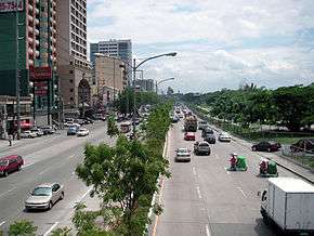
C-5 Road northbound towards Pasig.
-

The unfinished northern section of the C-5 Kalayaan elevated U-turn slot in March 2009, about two months before its completion.
See also
- Major roads in Metro Manila
- Metro Manila
- North Luzon Expressway
- South Luzon Expressway
- Coastal Road
- Epifanio de los Santos Avenue
References
- ↑ Google (January 5, 2013). "Circumferential Road 5" (Map). Google Maps. Google. Retrieved January 5, 2013.
- 1 2 3 4 "The Circumferential Road 5". scribd.com. Retrieved January 5, 2013.
- ↑ Flores, Asti (February 7, 2013). "MMDA, DPWH name C5 Road as alternate route for EDSA overhaul". GMA News. Retrieved March 30, 2013.
- 1 2 "Controversies regarding the C-5 Road". slideshare.net. Retrieved January 5, 2013.
- 1 2 "Overview of the Metro Manila Arterial Road System". Department of Public Works and Highways (Philippines). Retrieved January 5, 2013.
- ↑ Chan Robles Virtual Law Library. "REPUBLIC ACT NO. 8224-THE ACT OF CHANGING THE NAME OF THE C-5 ROAD TO CARLOS P. GARCIA AVENUE, TO HONOR CARLOS P. GARCIA, THE 8TH PRESIDENT OF THE REPUBLIC OF THE PHILIPPINES". Retrieved January 5, 2013.
- ↑ Official Gazette of the Republic of the Philippines. "State of the Nation Address, July 23, 2007". Retrieved March 30, 2013.
- ↑ Legaspi, Amita (January 25, 2012). "'Villar intervened in C-5 project for his own benefit'". GMA News. Retrieved March 17, 2013.
- ↑ Ranada, Pia (May 18, 2015). "High resolution West Valley Fault maps launched". Retrieved February 19, 2016.
- ↑ See, Aie (March 25, 2011). "C-5 Road, 3 Taguig barangays prone to liquefaction". Philstar. Retrieved February 19, 2016.
External links
- Map of Proposed C-5 Road North and South Extension-DPWH
- The C5 Extension controversy: An interactive map-GMANews.TV