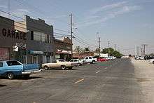
Byron, California
| Byron | |
|---|---|
| Census designated place | |
|
Byron sign | |
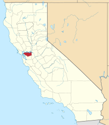
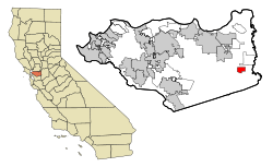 Location in Contra Costa County and the state of California | |
 Byron Location in the United States | |
| Coordinates: 37°52′02″N 121°38′17″W / 37.86722°N 121.63806°WCoordinates: 37°52′02″N 121°38′17″W / 37.86722°N 121.63806°W | |
| Country |
|
| State |
|
| County | Contra Costa |
| Government | |
| • State senator | Steve Glazer (D)[1] |
| • Assemblymember | Jim Frazier (D)[2] |
| • U. S. rep. | Jerry McNerney (D)[3] |
| Area[4] | |
| • Total | 6.487 sq mi (16.803 km2) |
| • Land | 6.487 sq mi (16.803 km2) |
| • Water | 0 sq mi (0 km2) 0% |
| Elevation[5] | 33 ft (10 m) |
| Population (April 1, 2010) | |
| • Total | 1,277 |
| • Density | 200/sq mi (76/km2) |
| Time zone | Pacific (UTC-8) |
| • Summer (DST) | PDT (UTC-7) |
| ZIP code | 94514 |
| Area code | 925 |
| FIPS code | 06-09346 |
| GNIS feature IDs | 238290, 2407934 |

Byron is a census designated place (CDP) in Contra Costa County, California, United States. The population was 1,277 at the 2010 census.

Geography
According to the United States Census Bureau, the CDP has a total area of 6.5 square miles (17 km2), all of it land. It is located 5.5 miles (9 km) southeast of Brentwood.[6]
Climate
This region experiences warm (but not hot) and dry summers, with no average monthly temperatures above 71.6 °F. Byron is windy, and dust devils sometimes appear. According to the Köppen Climate Classification system, Byron has a warm-summer Mediterranean climate, abbreviated "Csb" on climate maps.[7]
History
Byron's first post office opened in 1878.[6] Byron is named after an employee of the railroad.[6]

| Wikimedia Commons has media related to Japanese American internment processing in Byron, California. |
In 1942, all of the town's residents of Japanese descent were forcibly removed by the US government with pressure from California agricultural interests and taken to Turlock assembly center.[8][9]
Demographics
2010
The 2010 United States Census[10] reported that Byron had a population of 1,277. The population density was 196.8 people per square mile (76.0/km²). The racial makeup of Byron was 911 (71.3%) White, 61 (4.8%) African American, 11 (0.9%) Native American, 4 (0.3%) Asian, 11 (0.9%) Pacific Islander, 224 (17.5%) from other races, and 55 (4.3%) from two or more races. Hispanic or Latino of any race were 503 persons (39.4%).
The Census reported that 1,177 people (92.2% of the population) lived in households, 0 (0%) lived in non-institutionalized group quarters, and 100 (7.8%) were institutionalized.
There were 389 households, out of which 171 (44.0%) had children under the age of 18 living in them, 229 (58.9%) were opposite-sex married couples living together, 37 (9.5%) had a female householder with no husband present, 27 (6.9%) had a male householder with no wife present. There were 25 (6.4%) unmarried opposite-sex partnerships, and 3 (0.8%) same-sex married couples or partnerships. 76 households (19.5%) were made up of individuals and 25 (6.4%) had someone living alone who was 65 years of age or older. The average household size was 3.03. There were 293 families (75.3% of all households); the average family size was 3.50.
The population was spread out with 405 people (31.7%) under the age of 18, 136 people (10.6%) aged 18 to 24, 306 people (24.0%) aged 25 to 44, 312 people (24.4%) aged 45 to 64, and 118 people (9.2%) who were 65 years of age or older. The median age was 32.0 years. For every 100 females there were 112.8 males. For every 100 females age 18 and over, there were 106.6 males.
There were 415 housing units at an average density of 64.0 per square mile (24.7/km²), of which 254 (65.3%) were owner-occupied, and 135 (34.7%) were occupied by renters. The homeowner vacancy rate was 3.0%; the rental vacancy rate was 3.6%. 759 people (59.4% of the population) lived in owner-occupied housing units and 418 people (32.7%) lived in rental housing units.
2000
As of the census[11] of 2000, there were 916 people, 286 households, and 203 families residing in the CDP. The population density was 360.1 people per square mile (139.2/km²). There were 309 housing units at an average density of 121.5 per square mile (47.0/km²). The ethnic makeup of the CDP was 75.00% White, 4.37% Black or African American, 1.09% Native American, 2.18% Asian, 0.44% Pacific Islander, 14.74% from other races, and 2.18% from two or more races. 25.87% of the population were Hispanic or Latino of any race.
There were 286 households out of which 36.4% had children under the age of 18 living with them, 53.8% were married couples living together, 11.5% had a female householder with no husband present, and 28.7% were non-families. 22.0% of all households were made up of individuals and 9.8% had someone living alone who was 65 years of age or older. The average household size was 2.85 and the average family size was 3.36.
In the CDP the population was spread out with 35.0% under the age of 18, 9.1% from 18 to 24, 28.2% from 25 to 44, 18.8% from 45 to 64, and 9.0% who were 65 years of age or older. The median age was 31 years. For every 100 females there were 129.0 males. For every 100 females age 18 and over, there were 105.2 males.
The median income for a household in the CDP was $35,938, and the median income for a family was $44,306. Males had a median income of $42,639 versus $28,889 for females. The per capita income for the CDP was $21,231. About 15.6% of families and 14.9% of the population were below the poverty line, including 33.3% of those under age 18 and none of those age 65 or over.
Byron Hot Springs
37°50′54″N 121°38′00″W / 37.84833°N 121.63333°W
Byron, California is also home to the somewhat well-known and historical Byron Hot Springs, a now-abandoned resort that was a retreat that attracted many movie stars and famous athletes in the early 1900s. The first hotel was built in 1889 and was a three-story wood building, with a few cottages scattered nearby, as well as a laundry, gas plant and ice plant, all of which were destroyed by fire on July 25, 1901. A second hotel, also three stories, but made of stucco was constructed 1901-1902, but it burned on July 18, 1912. The third and final hotel, a four-story brick structure was built in 1913 and still stands.
In 1938 the resort closed, after a series of lawsuits that were probably brought about by the Great Depression, but was leased by the government in 1941 and became a military interrogation camp housing both German and Japanese prisoners of war, known as Camp Tracy, until 1945, when orders were sent to dismantle it. Additional information about its usage during World War II can be found in the book, The History of Camp Tracy: Japanese WWII POWs and the Future of Strategic Interrogation.
In 1947 the Byron Hot Springs property was put up for sale and purchased by the Greek Orthodox Church for a sum of $105,000. It served as the Monastery St. Paul for several years. It then changed hands several times as a resort, country club and private residence. It is currently privately owned by a developer who hopes to begin restoring the resort in early 2009, but the property is now in a state of disrepair.[12] Plans for the restoration of Byron Hot Springs are outlined at byronhotsprings.com.
In 2005, a Victorian-era carriage house on the property was burned to the ground. The hotel itself sustained some fire damage, but still stands.[13]
The site has most recently attracted graffiti artists, urban explorers, and photographers. The site has notably been used as the set of national Bay Area rap artist Mars for various projects including his Zodiac Tour commercial, and an interview with Insane Clown Posse on their Weekly Freakly Weekly internet news show. DJ Clay, who is also the DJ for Insane Clown Posse, shot parts of his music video for his single "Pen & Paper" here.
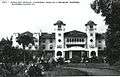 Second Byron Hot Springs Hotel, 1901 - 1912
 Postcard of Byron Hot Springs from 1914
 Byron Hot Springs 2008
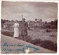 1908 photo of Byron Hot Springs
Byron Hot Springs is located 1.5 miles (2.4 km) south-southeast of Byron.[6] A post office operated at Byron Hot Springs from 1889 to 1930.[6]
Transportation
Byron Airport
In 1993 Contra Costa County broke ground on a new airport two miles (3 km) south of Byron. On October 8, 1994, Byron Airport was dedicated. The new airport has 1,307 acres (5.29 km2) of land. 814 acres (3.29 km2) are reserved for habitat management land for the San Joaquin kit fox, a federally listed endangered species, as well as many other endangered and special status species. The airport is also the home airport of the Patriots Jet Team.[14] Has also been used for illegal drag races in the past.
Bus
There is limited bus service to Byron by Tri-Delta Transit's route 386, which connects the community and Discovery Bay with the Brentwood Park and Ride Lot where passengers may transfer to buses connecting to other cities in the region in addition to Pittsburg/Bay Point (BART station) and Brentwood Dimes-A-Ride transit.[15]
References
- ↑ "Senators". State of California. Retrieved March 28, 2013.
- ↑ "Members Assembly". State of California. Retrieved March 28, 2013.
- ↑ "California's 9th Congressional District - Representatives & District Map". Civic Impulse, LLC. Retrieved March 9, 2013.
- ↑ "2010 Census U.S. Gazetteer Files – Places – California". United States Census Bureau.
- ↑ "Byron". Geographic Names Information System. United States Geological Survey. Retrieved October 20, 2014.
- 1 2 3 4 5 Durham, David L. (1998). California's Geographic Names: A Gazetteer of Historic and Modern Names of the State. Clovis, Calif.: Word Dancer Press. p. 609. ISBN 1-884995-14-4.
- ↑ Climate Summary for Byron, California
- ↑ https://research.archives.gov/id/537698?q=Dorothea%20Lange%20Byron
- ↑ https://research.archives.gov/id/537461?q=Dorothea%20Lange%20Byron
- ↑ "2010 Census Interactive Population Search: CA - Byron CDP". U.S. Census Bureau. Retrieved July 12, 2014.
- ↑ "American FactFinder". United States Census Bureau. Archived from the original on September 11, 2013. Retrieved 2008-01-31.
- ↑ "Developer has grand plan for crumbling resort", San Francisco Chronicle, November 9, 2008"
- ↑ Jensen, Carol A. (2006). Images of America: Byron Hot Springs. San Francisco, California: Arcadia Publishing. p. 128. ISBN 0-7385-4700-X.
- ↑ History of Contra Costa County Airports Archived August 20, 2008, at the Wayback Machine.. Retrieved 2007-08-14.
- ↑ Tri Delta Transit System Map, Tri Delta Transit, access date September 21, 2008
External links
- Byron Hot Springs 37°50′54″N 121°38′00″W / 37.84821°N 121.633241°W
- Reclamation District 800
- Byron Hot Springs
| Bodies of water |
|  |
|---|---|---|
| Counties | ||
| Major cities | ||
| Cities and towns 100k–250k | ||
| Cities and towns 50k–99k | ||
| Cities and towns 25k-50k | ||
| Cities and towns 10k–25k |
| |
| Sub-regions | ||