Bylakuppe
| Bylakuppe ಬೈಲಕುಪ್ಪೆ བ་ལ་ཀུ་པེ4 | |
|---|---|
| Town | |
|
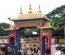
Outer View of Zangdog Palri Temple, Namdroling Monastery (Golden Temple) | |
| Nickname(s): Mini Tibet | |
| Coordinates: 12°24′15″N 76°01′42″E / 12.404270°N 76.028400°ECoordinates: 12°24′15″N 76°01′42″E / 12.404270°N 76.028400°E | |
| Country |
|
| State | Karnataka |
| District | Mysore |
| Named for | Tourism, pleasant climate |
| Area | |
| • Total | 10 km2 (4 sq mi) |
| Elevation | 1,024 m (3,360 ft) |
| Population (2011)(estimated) | |
| • Total | 70,000 (including Tibetans) |
| Languages | |
| • Official | Kannada |
| Time zone | IST (UTC+5:30) |
| PIN | 571104 |
| Telephone code | +91 8223 |
| Vehicle registration | KA-45 |
| Climate | Tropical wet and dry (Köppen) |


Bylakuppe (Kannada: ಬೈಲಕುಪ್ಪೆ Bailakuppe, Tibetan: བ་ལ་ཀུ་པེ་ Balakupé) is an area in Karnataka which is home to the Indian town Bylakuppe and several Tibetan settlements (there are several Tibetan settlements in India), established by Lugsum Samdupling (in 1961) and Dickyi Larsoe (in 1969). It is located to the west of Mysore district in the Indian state of Karnataka which is roughly 80 km from Mysore city. Twin (Indian) town Kushalanagar is about 6 kilometres (3.7 mi) from Bylakuppe. It also shares the border with Eastern part of Coorg district.
History
In 1960, the Government of Mysore (as Karnataka was called at that time) allotted nearly 3,000 acres (12 km2) of land at Bylakuppe in Mysore district in Karnataka and the first ever Tibetan exile settlement, Lugsung Samdupling came into existence in 1961. A few years later another settlement, Tibetan Dickey Larsoe, also called TDL, was established. This was followed by the establishment of three more settlements in Karnataka state making it the state with the largest Tibetan refugee population. Rabgayling settlement was created in Gurupura village near Hunsur, Dhondenling was established at Oderapalya near Kollegal and Doeguling settlement came into being at Mundgod in Uttara Kannada district, all in Karnataka. The Bir Tibetan Colony was established in Bir, Himachal Pradesh. Other states have provided land for Tibetan refugees.
The Government of India built special schools for Tibetans that provide free education, health care and scholarships for those students who excel in school. There are a few medical and civil engineering seats reserved for Tibetans. Tibetans live in India with a stay permit which is processed through a document called Registration Certificate (RC). It is renewed every year, or half-year in some areas. Every Tibetan refugee above the age of 16 must register for the stay permit. RCs are not issued to new arrival refugees. The Indian Government also issues "Yellow Books" after one years' processing with a RC, which allow Tibetans to travel abroad which is an Identity Certificate.
Population
The town is mainly inhabited by Tibetans who, according to a demographic survey carried out by the Central Tibetan Administration's Planning Commission[1] in 1998, accounted for 50,727 individuals at that time. However, it is unclear whether these figures included the Vajrayana Buddhist monks living there. Today, an estimated 70,000 Tibetans live in the settlements; these were established on land leased by the state government to accommodate some of the Tibetan expatriates who came to resettle in India after 1959. Bylakuppe consists of a number of agricultural settlements, colonies are close to each other, and has number of monasteries and temples in all the major Tibetan Buddhist traditions. Most notable among them are the large educational monastic institution Sera Monastery, the smaller Tashi Lhunpo Monastery (both in the Gelug tradition) and Namdroling Monastery (in the Nyingma tradition). Bylakuppe also has many Buddhist universities for advanced Buddhist practices.
Tibetan Buddhist Monasteries and Study Centers of Bylakuppe
- Namdroling Monastery of Nyingma Also known as Golden Temple
- Drigung Kagyud Monastery
- Sakya Monastery
- Sera je Monastery
- Sera Mey Monastery
- Tashi Lhunpo monastery in Bylakuppe was newly built. Inaugurated by Dalai Lama in 2016.[2]
Facilities
Bylakuppe is a small town. It has a police station, commercial banks, a telephone exchange, a post office, lodges and hotels. Transport facilities such as buses, auto-rickshaws and taxis are also available. PAP (Protected Area Permit) is mandatory for foreigners to stay here overnight, which can take up to three months to be issued.
Accessibility
Bylakuppe is situated on the state highway 88 (now NH 275) and is well connected to most of the major cities in south-India. Bus facilities are available from major towns like Mysuru, Bengaluru, Mangaluru, Chennai, Panaji, etc. Following are the distances between Bylakuppe and other cities in kilometers: Mysuru (82), Bengaluru (222), Mangaluru (172), Mandya (122), Chennai (582), Hassan (80), Madikeri (36), Kasaragod (145), Kozhikode (190).
Main attractions
- Ingalakere: Largest lake in Mysore district
- Namdroling Monastery[3] (Golden Temple)
- Sera Monastery
- Other Buddhist monasteries, schools and settlements
Image gallery
 Inside the Namdroling Monastery
 Sera Monastery
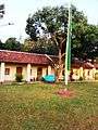 Tashi Lhunpo
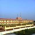 Tashi Lhunpo Hostel
Climate
Köppen-Geiger climate classification system classifies its climate as tropical wet and dry (Aw).[4]
| Climate data for Bylakuppe | |||||||||||||
|---|---|---|---|---|---|---|---|---|---|---|---|---|---|
| Month | Jan | Feb | Mar | Apr | May | Jun | Jul | Aug | Sep | Oct | Nov | Dec | Year |
| Average high °C (°F) | 26.1 (79) |
28.3 (82.9) |
30.6 (87.1) |
31 (88) |
29.6 (85.3) |
25.5 (77.9) |
23.8 (74.8) |
24.3 (75.7) |
25.5 (77.9) |
26.5 (79.7) |
26.2 (79.2) |
26 (79) |
26.95 (80.54) |
| Daily mean °C (°F) | 20.1 (68.2) |
21.1 (70) |
23.9 (75) |
25.5 (77.9) |
24.9 (76.8) |
22.4 (72.3) |
21.3 (70.3) |
21.5 (70.7) |
22 (72) |
21.6 (70.9) |
20.9 (69.6) |
20 (68) |
22.1 (71.81) |
| Average low °C (°F) | 14.8 (58.6) |
16 (61) |
17.7 (63.9) |
19.1 (66.4) |
19.3 (66.7) |
18.3 (64.9) |
17.9 (64.2) |
17.8 (64) |
17.6 (63.7) |
17.8 (64) |
16.7 (62.1) |
15.1 (59.2) |
17.34 (63.23) |
| Average precipitation mm (inches) | 20 (0.79) |
23 (0.91) |
98 (3.86) |
134 (5.28) |
198 (7.8) |
1,140 (44.88) |
1,989 (78.31) |
2,011 (79.17) |
1,743 (68.62) |
897 (35.31) |
104 (4.09) |
44 (1.73) |
8,401 (330.75) |
| Source: Climate-Data.org (altitude: 1014m)[4] | |||||||||||||
See also
- Kaveri Nisargadhama
- Dubare Elephant camp
- Kushalanagar
References
- ↑ "Encouraged By Rising Support From Intellectuals in China: His Holiness the Dalai Lama - Central Tibetan Administration". Tibet.net. Archived from the original on 2011-12-13. Retrieved 2014-03-15.
- ↑ http://www.thetibetpost.com/en/news/tibet/4842-his-holiness-the-dalai-lamas-arrival-at-tashi-lhunpo-monastery-in-bylakuppe
- ↑ "Welcome to Namdroling Monastery in India". Namdroling.org. Retrieved 2014-03-15.
- 1 2 "Climate: Bylakuppe - Climate graph, Temperature graph, Climate table". Climate-Data.org. Retrieved 2013-12-30.
External links
| Wikivoyage has a travel guide for Bylakuppe. |
![]() Media related to Bylakuppe at Wikimedia Commons
Media related to Bylakuppe at Wikimedia Commons
- Brief description of Dickyi Larsoe
- Brief description of Lugsum Samdupling
- Namdroling Monastery THE GOLDEN TEMPLE
- Sera Mey Monastery
- Sera Jey Monastery
- Tashi Lhunpo Monastery