Buxar district
| Buxar district बक्सर ज़िला | |
|---|---|
| District of Bihar | |
 Location of Buxar district in Bihar | |
| Country | India |
| State | Bihar |
| Administrative division | Patna |
| Headquarters | Buxar |
| Government | |
| • Lok Sabha constituencies | Buxar |
| Area | |
| • Total | 1,624 km2 (627 sq mi) |
| Population (2011) | |
| • Total | 1,707,643 |
| • Density | 1,100/km2 (2,700/sq mi) |
| Demographics | |
| • Literacy | 71.77 per cent |
| • Sex ratio | 922 |
| Major highways | NH 84 |
| Website | Official website |
Buxar district is one of the thirty-eight districts of Bihar state, India. The district headquarters are located at Buxar. Before 1992, it was part of Bhojpur District, Bihar. The major towns are Dumraon, Itarhi and Rajpur.
History
Buxar is famous as the scene of the defeat by Sir Hector Munro of Shuja-ud-Daula and Mir Kasim in 1764, while at CHAUSA, near by, Humayun was defeated by Sher Shah in 1539.[1]
Mythology
This place was also known as "Siddhashram", "Vedgarbhapuri", "Karush", "Tapovan", "Chaitrath", "VyaghraSar", "Buxar" in ancient history. The History of Buxar dates back even prior to the period of Ramayana. The word Buxar is said to have been derived from VyaghraSar. The tiger face of Rishi Vedshira, an outcome of the curse of the sage Rishi Durvasha, was restored after bathing in a holy tank which was later named as Vyaghra Sar.
According to mythology, sage Vishwamitra the family guru of Lord Rama and eighty eight thousand saints, had their sacred ashram at the banks of holy river Ganges that reside inside the modern District Buxar. He was disturbed in the yagna (sacrificial offering) by the demons. The place where due killing of the famous Rakshasi (demoness) Tadika by Lord Rama, is said to fall within the present Buxar town area. Besides, Lord Rama and his younger brother Laxman took their teachings at Buxar.
It is also said that Ahilya, the wife of Gautam Rishi restored her human body from that of stone and got salvation by a mere touch of the feet of Lord Rama. This place is now known as Ahirauli and is situated six kilometers away from the Buxar town. The Kanwaldah Pokhara also known as VyaghraSar is a tourist spot nowadays.[2]
Nath Baba Mandir(Temple) at the bank of Ganga River was built back in 1964, it was made by a foundation "Adi Nath Akhada". It is term “Nath Baba” is related to Lord Shiva. This temple has the replica of 12 Jyotirlinga, which is present throughout the Indian continent.The ghat is a popular spot for festivals like Chhath Puja.
Geography
Buxar district occupies an area of 1,703 square kilometres (658 sq mi),[3] comparatively equivalent to Australia's Bathurst Island.[4]
Sub-divisions
Buxar district comprises two sub-divisions:
- Buxar
- Dumraon
Buxar sub-division comprises four blocks: Buxar, Itarhi, Chousa and Rajpur. Dumraon sub-division comprises seven blocks: Dumraon, Nawanagar, Brahmpur, Kesath, Chakki, Chougain and Simri. A town is located each in Buxar and Dumraon Sub-division, that is Buxar (Municipality) and Dumraon (Municipality). Buxar is the 29th district of Bihar by its population rate but second largest district by its literacy percentage after Patna (capital of Bihar).
Transportation
The town Buxar is located on the bank of river Ganges (Ganga). A road bridge (Veer Kunwar Singh Setu) over Ganges connects Buxar with Ballia District of neighboring state Uttar Pradesh. The town is connected to the state capital Patna by rail and road routes. Substantial proportion of trade activities are with well connected towns and cities in Uttar Pradesh such as Varanasi, Ballia, Ghazipur, Lucknow. There are direct trains from Buxar to the metro cities of india like Banglore, Delhi, Jaipur, Kolkata, Ahmedabad, Mumbai etc.
Demographics
According to the 2011 census Buxar district has a population of 1,707,643,[5] roughly equal to the nation of The Gambia[6] or the US state of Nebraska.[7] This gives it a ranking of 285th in India (out of a total of 640).[5] The district has a population density of 1,003 inhabitants per square kilometre (2,600/sq mi).[5] Its population growth rate over the decade 2001–2011 was 21.77%.[5] Buxar has a sex ratio of 922females for every 1000 males,[5] and a literacy rate of 71.77%.[5]
Panchkoshi Parikrama
Many people once in a year take round of this religious area called Panchkoshi Parikrama. They perform it in five days by halting in night in five villages surrounding Buxar. During this visit they cook five different kinds of food. One of them is called litti-bhanta. This recipe is famous in Bihar, Litti is ball like structure made of wheat powder by filling the black gram roasted powder mixed with salt and spices called sattu. Bhanta (Round Brinjal) roasted in the fire of dung along with potato and tomato finally all are smashed after removing its peel and taken with litti which is also roasted in the same fire.somewhere it is known as bati-chokha.
Gallery
-

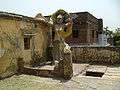
Sri nath baba mandir
-

Entrance of sri nath baba mandir
-

Naulakha Mandir
-
Statue of Tadka
-

Herd of Neelgais
-

Herd of Neelgais
-

Ghat near Sri nath baba mandir
-

A typical view of village in buxar
-
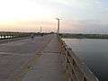
Buxar bridge
See also
List of villages in Buxar district
References
- ↑ http://dsal.uchicago.edu/reference/gazetteer/text.html?objectid=DS405.1.I34_V09_253.gif
- ↑ "Welcome to the official website of District Buxar, Bihar, India". buxar.bih.nic.in. Retrieved 2015-10-05.
- ↑ Srivastava, Dayawanti et al. (ed.) (2010). "States and Union Territories: Bihar: Government". India 2010: A Reference Annual (54th ed.). New Delhi, India: Additional Director General, Publications Division, Ministry of Information and Broadcasting (India), Government of India. pp. 1118–1119. ISBN 978-81-230-1617-7.
- ↑ "Island Directory Tables: Islands by Land Area". United Nations Environment Program. 1998-02-18. Retrieved 2011-10-11.
Bathurst Island1, 693km2
- 1 2 3 4 5 6 "District Census 2011". Census2011.co.in. 2011. Retrieved 2011-09-30.
- ↑ US Directorate of Intelligence. "Country Comparison:Population". Retrieved 2011-10-01.
Gambia, The 1,797,860 July 2011 est.
- ↑ "2010 Resident Population Data". U. S. Census Bureau. Archived from the original on 2010-01-01. Retrieved 2011-09-30.
Nebraska 1,826,341
External links
 |
Ballia district, Uttar Pradesh | | ||
| Ghazipur district, Uttar Pradesh | |
Bhojpur district | ||
| ||||
| | ||||
| Kaimur district | Rohtas district |
Coordinates: 25°33′56″N 83°58′33″E / 25.5656°N 83.9757°E