Butterby Oxbow
| Butterby Oxbow | |
| Site of Special Scientific Interest | |
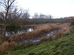 Oxbow lake at Low Butterby | |
| Country | England |
|---|---|
| Region | North East |
| District | Durham City |
| Location | NZ275390 |
| - coordinates | GB-ENG 54°44′44″N 1°34′25″W / 54.74556°N 1.57361°WCoordinates: GB-ENG 54°44′44″N 1°34′25″W / 54.74556°N 1.57361°W |
| Area | 7.29 ha (18.01 acres) |
| Notification | 1957 |
| Management | Natural England |
| Area of Search | County Durham |
| Interest | Biological |
.png) Location of Butterby Oxbow, Co Durham
| |
| Website: Map of site | |
Butterby Oxbow is a Site of Special Scientific Interest in the Durham City district of County Durham, England. It consists of a former meander of the River Wear which was isolated from the main river in 1811 when, to reduce flooding in the area, a new channel was constructed across the neck of the meander.[1] It is located about 3 km south of the centre of Durham and 1.2 km north of the nearest village, Croxdale.
The site is notable for the succession series of swamp, fen and fen-carr which has developed and which is rarely found as a complete sequence in the county. It is locally important as a roosting and wintering area for wildfowl.[2]
References
- ↑ Griffiths, Benjamin M (February 1932). "The Ecology of Butterby Marsh, Durham". Journal of Ecology. 20 (1): 105–127. doi:10.2307/2255969. JSTOR 2255969.
- ↑ "Butterby Oxbow" (PDF). English Nature. 1985. Archived from the original (PDF) on 22 June 2011. Retrieved 18 July 2010.
This article is issued from Wikipedia - version of the 11/11/2016. The text is available under the Creative Commons Attribution/Share Alike but additional terms may apply for the media files.