Butler, Waukesha County, Wisconsin
| Butler | |
|---|---|
| Village | |
| Nickname(s): "Train Town USA" | |
| Motto: "Village of Homes & Industry" | |
 Location in Waukesha County and the state of Wisconsin. | |
| Coordinates: 43°6′26″N 88°4′8″W / 43.10722°N 88.06889°WCoordinates: 43°6′26″N 88°4′8″W / 43.10722°N 88.06889°W | |
| Country | United States |
| State | Wisconsin |
| County | Waukesha |
| Area[1] | |
| • Total | 0.79 sq mi (2.05 km2) |
| • Land | 0.78 sq mi (2.02 km2) |
| • Water | 0.01 sq mi (0.03 km2) |
| Population (2010)[2] | |
| • Total | 1,841 |
| • Estimate (2012[3]) | 1,838 |
| • Density | 2,360.3/sq mi (911.3/km2) |
| Time zone | Central (CST) (UTC-6) |
| • Summer (DST) | CDT (UTC-5) |
| Website | Village of Butler, Wisconsin |
Butler is a village in Waukesha County, Wisconsin, United States. The population was 1,841 at the 2010 census.
History
The village was established in 1913.[4]
Geography
Butler is located at 43°6′26″N 88°4′8″W / 43.10722°N 88.06889°W (43.107310, −88.068963).[5]
According to the United States Census Bureau, the village has a total area of 0.79 square miles (2.05 km2), of which, 0.78 square miles (2.02 km2) of it is land and 0.01 square miles (0.03 km2) is water.[1]
Demographics
| Historical population | |||
|---|---|---|---|
| Census | Pop. | %± | |
| 1920 | 564 | — | |
| 1930 | 703 | 24.6% | |
| 1940 | 778 | 10.7% | |
| 1950 | 1,047 | 34.6% | |
| 1960 | 2,274 | 117.2% | |
| 1970 | 2,261 | −0.6% | |
| 1980 | 2,059 | −8.9% | |
| 1990 | 2,079 | 1.0% | |
| 2000 | 1,881 | −9.5% | |
| 2010 | 1,841 | −2.1% | |
| Est. 2015 | 1,825 | [6] | −0.9% |
2010 census
As of the census[2] of 2010, there were 1,841 people, 895 households, and 430 families residing in the village. The population density was 2,360.3 inhabitants per square mile (911.3/km2). There were 925 housing units at an average density of 1,185.9 per square mile (457.9/km2). The racial makeup of the village was 92.2% White, 3.0% African American, 0.7% Native American, 1.2% Asian, 0.1% Pacific Islander, 0.9% from other races, and 1.8% from two or more races. Hispanic or Latino of any race were 4.8% of the population.
There were 895 households of which 21.2% had children under the age of 18 living with them, 33.9% were married couples living together, 8.8% had a female householder with no husband present, 5.4% had a male householder with no wife present, and 52.0% were non-families. 44.4% of all households were made up of individuals and 20.1% had someone living alone who was 65 years of age or older. The average household size was 2.06 and the average family size was 2.92.
The median age in the village was 43.2 years. 17.6% of residents were under the age of 18; 8.8% were between the ages of 18 and 24; 25.7% were from 25 to 44; 29.1% were from 45 to 64; and 18.9% were 65 years of age or older. The gender makeup of the village was 47.5% male and 52.5% female.
2000 census
As of the census[8] of 2000, there were 1,881 people, 916 households, and 459 families residing in the village. The population density was 2,376.2 people per square mile (919.3/km²). There were 938 housing units at an average density of 1,184.9/sq mi (458.4/km²). The racial makeup of the village was 97.40% White, 0.27% African American, 1.06% Native American, 0.48% Asian, 0.16% Pacific Islander, and 0.64% from two or more races. Hispanic or Latino of any race were 0.85% of the population.
There were 916 households out of which 20.7% had children under the age of 18 living with them, 39.0% were married couples living together, 8.1% had a female householder with no husband present, and 49.8% were non-families. 42.5% of all households were made up of individuals and 25.3% had someone living alone who was 65 years of age or older. The average household size was 2.05 and the average family size was 2.88.
In the village the population was spread out with 19.5% under the age of 18, 6.2% from 18 to 24, 30.8% from 25 to 44, 20.0% from 45 to 64, and 23.5% who were 65 years of age or older. The median age was 41 years. For every 100 females there were 89.8 males. For every 100 females age 18 and over, there were 86.1 males.
The median income for a household in the village was $38,333, and the median income for a family was $50,903. Males had a median income of $35,781 versus $26,250 for females. The per capita income for the village was $22,167. None of the families and 2.4% of the population were living below the poverty line, including no under eighteens and 7.8% of those over 64.
References
- 1 2 "US Gazetteer files 2010". United States Census Bureau. Archived from the original on 2012-01-24. Retrieved 2012-11-18.
- 1 2 "American FactFinder". United States Census Bureau. Retrieved 2012-11-18.
- ↑ "Population Estimates". United States Census Bureau. Archived from the original on 2013-06-17. Retrieved 2013-06-24.
- ↑ "Village of Butler, Wisconsin". Village of Butler, Wisconsin. Retrieved July 21, 2012.
- ↑ "US Gazetteer files: 2010, 2000, and 1990". United States Census Bureau. 2011-02-12. Retrieved 2011-04-23.
- ↑ "Annual Estimates of the Resident Population for Incorporated Places: April 1, 2010 to July 1, 2015". Retrieved July 2, 2016.
- ↑ "Census of Population and Housing". Census.gov. Archived from the original on May 11, 2015. Retrieved June 4, 2015.
- ↑ "American FactFinder". United States Census Bureau. Archived from the original on 2013-09-11. Retrieved 2008-01-31.
External links
- Village of Butler, Wisconsin website
- Butler Chamber of Commerce website
- Butler Public Library website
Municipalities and communities of Waukesha County, Wisconsin, United States | ||
|---|---|---|
| Cities | 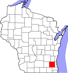 | |
| Villages | ||
| Towns | ||
| CDP | ||
| Unincorporated communities | ||
| Ghost towns | ||
| Footnotes | ‡This populated place also has portions in an adjacent county or counties | |
| Central city |  | |
|---|---|---|
| Largest municipalities (over 25,000 in 2010) | ||
| Municipalities (over 10,000 in 2010) | ||
| Smaller municipalities (under 10,000 in 2010) | ||
| Counties | ||