Burmantofts
| Burmantofts | |
 St Agnes Church with Shakespeare Towers behind |
|
 Burmantofts |
|
| Population | 24,863 (Burmantofts and Richmond Hill Ward. 2011) |
|---|---|
| Metropolitan borough | City of Leeds |
| Metropolitan county | West Yorkshire |
| Region | Yorkshire and the Humber |
| Country | England |
| Sovereign state | United Kingdom |
| Post town | LEEDS |
| Postcode district | LS9 |
| Dialling code | 0113 |
| Police | West Yorkshire |
| Fire | West Yorkshire |
| Ambulance | Yorkshire |
| EU Parliament | Yorkshire and the Humber |
| UK Parliament | Leeds North East |
Coordinates: 53°48′17″N 1°31′00″W / 53.8048°N 1.5166°W
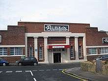
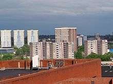
Burmantofts is an area of 1960s high-rise housing blocks in inner-city east Leeds, West Yorkshire, England adjacent to the city centre and St. James's Hospital. It is a racially diverse area, with sizable Afro-Caribbean, Irish communities and Asylum Seekers, but suffers the social problems typical of similar areas across the country. The area has a small selection of pubs and the Anglers Club on Nippet Lane. Burmantofts is perhaps most notable for Burmantofts Pottery and the former Burtons textile factory, which is still owned by Burtons, but only used as a storage facility. In the 1900s and early twentieth century, Burmantofts was a large centre of the textile industry.
History
The name comes from the half-acre parcels of land (or tofts) given to owners of building plots (or burgages) by the River Aire, thus Burgage Men's Tofts.[1] The burgage men pursued craft businesses in the town, and grew crops on their tofts, such as grain which would be processed at the nearby mill on what is now Miles Hill.[2]
Burmantofts grew alongside Leeds during the industrial revolution, and provided Leeds with many of its textile works. As a rule of thumb, North, East and West Leeds developed textile industries while South Leeds was centred on more heavy engineering, such as foundries and engine works.
The Burmantofts Pottery started in 1842 and closed down in 1957. The land was bought by Leeds in 1960, cleared and made into the Shakespeare school and housing estate.[3]
In 1878, Burmantofts was the site of Leeds' first municipal waste incinerator, making use of a former industrial chimney.[4]
After the Second World War Burmantofts was in a very poor condition, however redevelopment did not occur for sometime. While the area was dilapidated and buildings such as the Pineapple Hotel (no 77 Accommodation Road) stood derelict for many years throughout the 1930s and 1940s,[5] no real redevelopment started until the mid-1950s, most of this however was just demolition and in this time only a handful of houses were built around Torre Road and Lupton Avenue.
St Agnes' Church

The only historic building in the area is St Agnes' United Reformed Church on Stoney Rock Lane, which was built 1887–9 in Gothic Revival style with stone walls and a slate roof. It was consecrated by the Bishop of Ripon on 20 May 1889.[6][7] It became the parish church in the 1930s when the church of St Stephen (built 1851) was demolished. The west window stained glass in St Agnes' was originally in St Stephen's. The church has a reredos of Burmantofts faience.[6][7]
Housing
There was relatively little housing in Burmantofts until the twentieth century, just a few low rent houses built amongst the mills. Most of the workers in Burmantofts would have lived in nearby areas such as Harehills, however redevelopment through the 1950s and 1960s brought high density living to Burmantofts and it is this redevelopment that has shaped modern Burmantofts.
By the 1960s, neighbouring Lincoln Green was seeing many new high rise council flats being erected, however it did not take long for Burmantofts to catch up and by the mid-1960s most of the blocks that stand today had been completed. Burmantofts as it is known today was completed around the early 1970s, since then changes in the area have been few and far between.
Burmantofts has changed very little in the last forty years, the only area of change is a St James' Hospital, which separated Harehills and Burmantofts. St Bridgets R.C. Secondary Modern School on Torre Road closed down in the 1980s and is now St. Patrick's Primary School, while the transport depot opposite is now the site of Benfield Ford. In September 2006, the area's main secondary school, Primrose High School moved into new premises. With regards to housing, Leeds City Council has not proposed any regeneration in the area, and in recent years is focusing on areas of early-twentieth century back-to-back housing such as Beeston and Holbeck. There has however been refurbishment of a number of blocks.
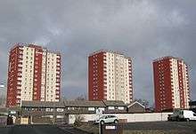
As of the present day, the majority of the housing in Burmantofts is mid-twentieth century council-owned housing, mostly made up by multi-story blocks of flats of various heights. A small number of 19th century houses remain close to the Burtons warehouse.
Population

Burmantofts has a sizeable Afro Caribbean community. The age range of Burmantofts residents is quite varied, with probably the two largest age groups being young adults and the elderly. Burmantofts has a high unemployment rate, which is one of the contributing factors to its low house prices.
Politics
Burmantofts falls into the 'Burmantofts and Richmond Hill' ward for Leeds City Council local elections. In 2007, Burmatofts elected the Liberal Democrat, with the Labour candidate coming second, while the British National Party and the Conservatives stood very much as minority parties in the area, with the Conservatives finishing last. The results imply the area has left leaning political views. The results were as follows:
Leeds City Council Election 4 May 2007
- Richard Jeffrey Brett (Lib Dem) 2,331 (48.13%)
- Ron Grahame (Lab) 1,450 (29.94%)
- Mark Adrian Collett (BNP) 898 (18.54%)
- Elliott Burton (Con) 164 (3.39%)
Total votes cast 4843[8]
The Labour Party candidate for 2012 is Maureen Ingham
The population of the ward at the 2011 Census was 24,843.[9]
Transport
Burmantofts is situated adjacent to the A64 road. It has regular bus routes to the city centre and to other parts of the city, in particular East Leeds. The proposed Leeds Supertram Eastern line was supposed to run in-between Burmantofts and Harehills, however the future of this scheme is uncertain. Other projects have been considered using this route including the Leeds Trolleybus. There is no railway station in Burmantofts, the nearest being Leeds and Cross Gates.
Facilities


Burmantofts has fairly limited facilities. Neighbouring Lincoln Green has a small shopping precinct with a Freshways, Costcutter, Cash Converters and other shops, this is walking distance for most of Burmantofts. Burmantofts itself has Ebor Garden's Primary and St Peter's Primary, the Anglers Club on Nippet Lane, The Sportsman' public house on Stoney Rock Lane and The New Torre on Torre Road. Burmantofts is in most parts less than a mile from the Eastern fringes of Leeds city centre providing it with many other amenities close by. Burmantofts amateur boxing club are based in parts of the former Burtons factory, on the corner of Hudson Road and Stoney Rock Lane [10]
Education
Burmantofts only has one secondary school, this being The Co-operative Academy of Leeds. Shakespeare Primary School is on the same site.
People
- Elizabeth Dawn, actress best known for her portrayal of Vera Duckworth in Coronation Street was born and raised in the area.
- Nicola Virginia Adams, the first woman to win an Olympic boxing gold medal, was raised in the area.
- Jabez Tunnicliff, founder of the Band of Hope temperance society, was buried at Burmantofts Cemetery on Sunday 18 June 1865, with a reported attendance of 15,000.[11]
Location grid
 |
Harehills | | ||
| Leeds city centre | |
Gipton | ||
| ||||
| | ||||
| East End Park |
References
- ↑ www.leeds.gov.uk Archived 31 May 2007 at the Wayback Machine. Discovering Leeds – Industrial Leeds
- ↑ Thoresby Society A Brief History of Leeds
- ↑ BBC Leeds Local History Glazed Over
- ↑ Scientific American Supplement. Vol. XIV, No. 362 (1882) via Gutenberg
- ↑ http://www.leodis.net/display.aspx?resourceIdentifier=6816&DISPLAY=FULL
- 1 2 St Agnes' United Reformed Church. Undated leaflet available from the Church.
- 1 2 Church web page
- ↑ http://www.yorkshireeveningpost.co.uk/elections/Burmantofts-amp-Richmond-Hill.2855516.jp
- ↑ "City of Leeds Ward population 2011". Neighbourhood Statistics. Office for National Statistics. Retrieved 26 February 2016.
- ↑ http://www.yorkshireeveningpost.co.uk/features/Boxing-club-fights-its-way.1824384.jp
- ↑ Leeds Express 25 June 1865
External links
| Wikimedia Commons has media related to Burmantofts. |
- The ancient parish of Leeds: historical and genealogical information at GENUKI (Burmantofts was in this parish).