Burke, Wisconsin
| Burke, Wisconsin | |
|---|---|
| Town | |
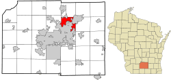 Location in Dane County and the state of Wisconsin. | |
| Coordinates: 43°9′54″N 89°17′43″W / 43.16500°N 89.29528°W | |
| Country | United States |
| State | Wisconsin |
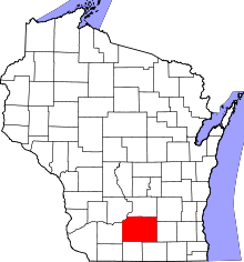
| County | Dane |
| Area | |
| • Total | 19.5 sq mi (50.5 km2) |
| • Land | 19.5 sq mi (50.5 km2) |
| • Water | 0.0 sq mi (0.0 km2) |
| Elevation[1] | 938 ft (286 m) |
| Population (2010) | |
| • Total | 3,284 |
| • Density | 153.4/sq mi (59.2/km2) |
| Time zone | Central (CST) (UTC-6) |
| • Summer (DST) | CDT (UTC-5) |
| Area code(s) | 608 |
| FIPS code | 55-11150[2] |
| GNIS feature ID | 1582887[1] |
Burke is a town in Dane County, Wisconsin, United States. The population was 3,284 at the 2010 census.[2] The unincorporated communities of Burke and Seminary Springs are in the town.
History
The town is set to be annexed by the City of Madison, the Village of De Forest, and the City of Sun Prairie by 2036.[3]
Geography
According to the United States Census Bureau, the town has a total area of 19.5 square miles (50.5 km²), all of it land.
Demographics
As of the census[2] of 2000, there were 2,990 people, 1,148 households, and 862 families residing in the town. The population density was 153.4 people per square mile (59.2/km²). There were 1,208 housing units at an average density of 62.0 per square mile (23.9/km²). The racial makeup of the town was 96.15% White, 0.90% African American, 0.27% Native American, 1.04% Asian, 0.43% from other races, and 1.20% from two or more races. Hispanic or Latino of any race were 1.57% of the population.
There were 1,148 households out of which 33.4% had children under the age of 18 living with them, 65.9% were married couples living together, 5.8% had a female householder with no husband present, and 24.9% were non-families. 17.5% of all households were made up of individuals and 4.3% had someone living alone who was 65 years of age or older. The average household size was 2.60 and the average family size was 2.95.
In the town the population was spread out with 24.0% under the age of 18, 6.8% from 18 to 24, 32.4% from 25 to 44, 29.6% from 45 to 64, and 7.1% who were 65 years of age or older. The median age was 38 years. For every 100 females there were 103.3 males. For every 100 females age 18 and over, there were 102.2 males.
The median income for a household in the town was $67,273, and the median income for a family was $72,065. Males had a median income of $43,125 versus $29,469 for females. The per capita income for the town was $28,458. About 1.3% of families and 2.9% of the population were below the poverty line, including none of those under age 18 and 8.0% of those age 65 or over.
Notable people
- Hiram N. Moulton - Mayor of Madison, Wisconsin
- John M. Nelson - U.S. Representative
- Herman W. Sachtjen - Wisconsin State Assemblyman and jurist
- William Robert Taylor - Governor of Wisconsin
References
- 1 2 "US Board on Geographic Names". United States Geological Survey. 2007-10-25. Retrieved 2008-01-31.
- 1 2 3 "American FactFinder". United States Census Bureau. Archived from the original on 2013-09-11. Retrieved 2008-01-31.
- ↑ Final Cooperative Plan
External links
- Town of Burke, Wisconsin website
- 1861 plat map of Burke
- 1873 plat map
- 1890 plat map
- 1899 plat map
- 1911 plat map
- 1947 plat map
- 1955 plat map
| Surrounding communities |
|  | ||||||
|---|---|---|---|---|---|---|---|---|
| Counties | ||||||||
Coordinates: 43°08′09″N 89°16′34″W / 43.13583°N 89.27611°W