Buriton
| Buriton | |
 Buriton |
|
| Population | 736 (2001) |
|---|---|
| OS grid reference | SU739200 |
| Civil parish | Buriton |
| District | East Hampshire |
| Shire county | Hampshire |
| Region | South East |
| Country | England |
| Sovereign state | United Kingdom |
| Post town | Petersfield |
| Police | Hampshire |
| Fire | Hampshire |
| Ambulance | South Central |
| EU Parliament | South East England |
Coordinates: 50°58′37″N 0°56′56″W / 50.977°N 0.949°W
Buriton is a village and civil parish in the East Hampshire district of Hampshire, England, 2 miles (3.3 km) south of Petersfield.
It lies at the foot of the South Downs escarpment, just east of the A3 road. One kilometre to the south rises the tree-covered hill of Head Down (205 m), one of the highest points of the South Downs and flanked on either side by two other high points, War Down (244 m) and Oakham Hill (202 m).
The nearest railway station is 2 miles (3.3 km) north of the village, at Petersfield.
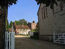
The village boasts two tennis courts, two pubs - The Five Bells and the The Maple Inn, a village hall, a large village pond with ducks and fish, a car park and the Church of St. Mary. There is no shop in the village. The village has its own school, "Buriton Primary School", with about 80 pupils from the village and nearby.
The main roads of Buriton are called High Street and Petersfield Road.
It is a rural, peaceful place, with the possible exception of the main railway line, the Portsmouth to London line (Portsmouth Direct Line). The railway tunnel which carries the line under the South Downs is visible from the recreation ground. There is a pedestrian crossing over the railway at this point which the trains 'hoot' for as a warning to those crossing the line. There is also a path under the railway bridge from South Lane. Both paths lead to the walks around the disused chalk pits. Although for centuries the village was deemed of more importance than neighbouring Petersfield, Buriton never obtained its own railway station (aside from Woodcroft Halt, built during World War II for naval personnel), because the gradient in the area was deemed too steep to allow a station to be constructed.[1]
It formerly marked the Western end of the South Downs Way, which has now been extended to Winchester but several paths still join the village to the Way, and it retains its popularity with walkers. The Sussex Border Path also passes through South Harting which is close by. Buriton also lies adjacent to the Queen Elizabeth Country Park and since 2011 it has been within the South Downs National Park.
The local landowners until recent times were the Bonham-Carters who owned land surrounding Buriton and neighbouring villages where they often reared game for local shoots. The Legg family were gamekeepers for the Bonham-Carters for many years.[2] Other forms of employment in the past have been in the local Lime Kilns which closed in 1920.[3] Hop picking was also another form of employment in the past.[4] Today, Buriton remains a pleasant and quiet village with a very strong sense of its own identity. Employment needs are met outside the village.
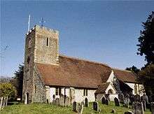
Edward Gibbon, author of the classic Decline and fall of the Roman Empire, among other works, lived at Buriton Manor for much of the second half of the eighteenth century.[5] John Goodyer, the seventeenth century botanist was buried at St Mary's and is commemorated with a stained glass window there.
References
- ↑ Buriton Heritage Bank, Buriton In Living Memory; Godfrey Croughton, et al., Private and Untimetabled Railway Stations (Salisbury: Oakwood Press, 1982), p.142.
- ↑ Information sheet no. 5, Buriton Heritage Bank.
- ↑ Information sheet no. 1, Buriton Heritage Bank.
- ↑ Information sheet no. 3, Buriton Heritage Bank.
- ↑ Information sheet no. 5, Buriton Heritage Bank.
External links
- W. H. Hudson literary walk: https://web.archive.org/web/20120319233737/http://www.easthants.gov.uk/edo/tourism.nsf/0/753b8df1a2bd1b5c80256c460052ea0c/$FILE/wh_hudson_walk.pdf
- Brief History
- 'Parishes: Buriton', A History of the County of Hampshire: Volume 3 (1908), pp. 85–93.
- Buriton Heritage Bank, community local history project
![]() Media related to Buriton at Wikimedia Commons
Media related to Buriton at Wikimedia Commons
