Burghead
| Burghead | |
| Scottish Gaelic: Am Broch | |
| Scots: Burgheid / The Broch | |
 Burghead seafront |
|
 Burghead |
|
| Population | 1,640 (2001 census)[1] est. 1,650 (2006)[2] |
|---|---|
| Language | English |
| Scots (Doric) | |
| OS grid reference | NJ116688 |
| – Edinburgh | 168 miles (262 km) |
| – London | 555 miles (894 km) |
| Civil parish | Duffus |
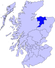
| Council area | Moray |
| Lieutenancy area | Moray |
| Country | Scotland |
| Sovereign state | United Kingdom |
| Post town | ELGIN |
| Postcode district | IV30 |
| Dialling code | 01343 |
| Police | Scottish |
| Fire | Scottish |
| Ambulance | Scottish |
| EU Parliament | Scotland |
| UK Parliament | Moray |
| Scottish Parliament | Moray |
| Website | burghead.com |
Coordinates: 57°42′00″N 3°29′06″W / 57.700°N 3.485°W
Burghead (Scots: Burgheid[3] or The Broch,[4] Scottish Gaelic: Am Broch) is a small town in Moray, Scotland, about 8 miles (13 km) north-west of Elgin. The town is mainly built on a peninsula that projects north-westward into the Moray Firth, meaning that most of the town has sea on 3 sides. The present town was built between 1805 and 1809, destroying in the process more than half of the site of an important Pictish hill fort. General Roy’s map shows the defences as they existed in the 18th century but he wrongly attributed them to the Romans. The fort was probably a major Pictish centre and was where carved slabs depicting bulls were found; they are known as the "Burghead Bulls". A chambered well of some considerable antiquity was discovered in 1809 and walls and a roof were later added to help preserve it. Each year on 11 January a fire festival known as the Burning of the Clavie takes place; it is thought that the festival dates back to the 17th century, although it could easily predate this by several centuries. Burghead is often known as The Broch by locals; confusingly, Fraserburgh is also known by this name. A recent dig just beyond the boundary of Burghead at Clarkly Hill has uncovered Iron Age circular stone houses and Pictish building foundations, as well as silver and bronze Roman coins and a gold finger ring possibly from the Baltic region. Significant evidence of large scale Iron smelting has also been found, providing evidence that iron was probably being traded from this site. The National Museum of Scotland has carried out significant exploration which leads it to believe this is a significant site of interest.
History


Iron age fort
This vitrified fort lies on top of a headland which commands extensive views of the Moray Firth. Originally believed to be Ptolemy's Castra Alata, later 'Ptoroton' and the 'Torffness' of the Orkneyinga Saga, it is now known to be of Pictish origin and is thought to be the oldest Pictish fort. It encloses 3 hectares and is three times as large as any other fort of the same period in Scotland. It was defended on the landward side by three banks and ditches which were destroyed during the creation of the harbour and modern village; their age is therefore uncertain.[5] Six striking carved slabs known as the "Burghead Bulls" were discovered during excavations. Dating to 7th Century AD, four of the originals are held locally in Burghead Visitor Centre and Elgin Museum and one each in the Royal Museum, Edinburgh, and the British Museum, London.[6] Much of the fort was destroyed during the building of the village from 1805 to 1809. The Doorie Hill (see below), which marked the junction of the citadel and the bailey, is the only remaining piece of the southern ramparts. Lengths of the eastern and northern ramparts are also still visible.[7][8][9]
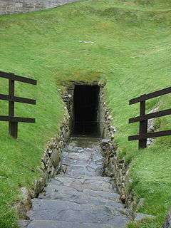
Chambered well
The Burghead Well, which lies within the perimeter of the promontory fort, was discovered in 1809. It consists of a flight of stone steps leading down to a chamber containing a tank fed by springs. There is a frieze in the upper walls, a pedestal in the southeast corner and a sunken basin in the northwest corner. The chamber is 11 feet (3.4 m) high, and 11 feet (3.4 m) across with a 4-foot (1.2 m) wide ledge around the edge, and the tank is 4 feet (1.2 m) deep. The discovery was made during excavations for a possible municipal water supply after an elderly fisherman recalled a tradition of a well in the vicinity. Various additions such as re-cutting the steps and deepening the tank were undertaken, but the flow of water proved to be insufficient for the proposed new function. At the time of discovery it was assumed that both the fort and well were of Roman antiquity and it was described as a 'Roman bath'. Later in the 19th century it was suggested that it was an early Christian baptistery possibly associated with the cult of St Aethan, but its origins remain obscure to this day. It is almost certainly of Dark Age provenance and clearly had some ceremonial significance.[7][8][10] It is possible that its main purpose was as a water supply for the fort and may suggest a Pictish interest in water spirits.[9]
Burning of the Clavie
Jan1984.jpg)
A fire festival called the Burning of the Clavie is held on 11 January each year, except when the 11th is a Sunday, in which case it takes place on the 10th. The event starts when the Clavie is lit on Granary Street at 18:00 and normally ends by 19:30.
In 1599 the Parliament of Scotland passed a law which, while retaining the Julian calendar, provided that, beginning in 1600, the first day of the year would be 1 January. In 1752 Great Britain, including Scotland, adopted the Gregorian calendar, removing 11 days from the calendar by stipulating that the day following 2 September would be not 3 September but 14 September. The day that would have been New Year's Day in the old calendar now fell on 12 January of the new calendar. The Burning of the Clavie continues to be celebrated on the former New Year's Eve—that is, in the new calendar, on 11 January.
The practice has survived clerical condemnation. On 20 January 1689, the young men of the village were rebuked by the church courts for "having made a burning clavie, paying it superstitious worship, and blessing the boats after the old heathen custom".[11]
The Clavie is a barrel cut down to 17 inches, which is filled with tar and bits of wood. It is nailed onto a pole [which is 4 foot 6 inches long] with a specially forged nail. It has to be specially made to leave a space for the carrier’s head to fit between the staves (6 in all) and allowing him to rest it partly on his shoulders while he carries it. A group of about 15 men known as the Clavie crew, traditionally fishermen and headed by the Clavie king, take turns to carry the burning Clavie on a set route clockwise round the streets of the old part of the town. The Clavie crew stop to present bits of smouldering embers to certain households and the three public houses in the village to bring them good luck for the following year. There are also two set points where they stop to refuel. At the end of the route the Clavie is put onto a stone altar (which was not constructed until the 19th century) upon Doorie Hill,[7] and more fuel is added, often setting the whole side of the hill alight in the process. The barrel eventually collapses and the blazing embers are scattered all over the hilltop before they are collected and given out for good luck,[12] although it is said that in the past the embers were kept as charms against witchcraft.[13] It used to be customary to carry the Clavie round every boat and vessel in the harbour, but this part of the ceremony was later discounted,[14] presumably because it became impossible as the harbour became busier.
Ship Building
Alexander Stephen founded his company Alexander Stephen and Sons and began shipbuilding at Burghead on the Moray Firth in 1750.[15] For Reference A Shipbuilding History 1750-1932 Alexander Stephen & Sons Ltd. A Record of the Business founded about 1750, by Alexander Stephen at Burghead, and subsequently carried on at Aberdeen, Arbroath, Dundee,and Glasgow.
Education

Primary and secondary
- For primary education, there is just Burghead Primary School, a non-denominational Primary state school in Grant Street in the centre of the town. The school educates in a nursery school and years 1-7. There is a school roll of 128.[16] Students are grouped into three houses; Clavie, St Aethans and Torfness.
- For secondary education, free transport is provided to two schools in nearby towns. Students can therefore choose to attend either Lossiemouth High School[17] or Elgin Academy.[18]
Further education
- Moray College is located approximately nine miles away in Elgin.
- Ecosse Performers College is located approximately eight miles away in Lossiemouth.
Politics
UK and Scottish parliaments
- Burghead is part of the Moray constituency of the Parliament of the United Kingdom which returns a Member of Parliament (MP) to the House of Commons, at Westminster.[19]
- Burghead is part of the Moray constituency of the Scottish Parliament which has slightly different boundaries to the Westminster constituency. The constituency returns a Member of the Scottish Parliament (MSP) to Holyrood.[20] The Moray constituency is also part of the Highlands and Islands electoral region which returns 7 regional MSPs to Holyrood.[21]
Local government
- see also Moray council election, 2007
Burghead is represented at The Moray Council by the Heldon & Laich ward, from which four councillors are elected. The members elected from this ward as of 3 May 2007 are: Allan Grant Wright (Scottish Conservative and unionist), John Christopher Hogg (Independent), Eric Morrison Mcgillivary (Independent) and David Christie Stewart (Scottish National Party).[22] Moray Council is currently controlled by an Independent/Conservative Coalition.[23]
Burghead was previously represented at Moray Council by the Burghsea ward from which one councillor was elected under the first past the post electoral system. Since 3 May 2007 the STV electoral system has been used in local elections throughout Scotland, which means that Burghead is represented by several councillors in the significantly larger Heldon & Laich ward.
Population (demography)
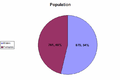
The population of Burghead in 1991 according to the 1991 Census was 1,495.[24] Data from the 2001 Census showed Burghead's population had risen to 1,640;[25] however, mid-2004 estimates showed the population had risen again slightly to 1,680.[26] The 2001 data makes Burghead the eighth-largest town in Moray behind Keith, Kinloss and Lhanbryde but ahead of Hopeman, Dufftown and Fochabers.
Males in Burghead make up 53.6% of the population; this is higher than the figure of 49.97% for Moray which itself is slightly higher than the 48.05% for Scotland. Males in Burghead do not outnumber females nearly as much over the age of 25 as they do under 25, as the number of males per female is significantly lower over age 25 (1.05) than it is under 25 (1.45).
| Population | Place of birth | Age structure | Religion | Ethnic group |
|---|---|---|---|---|
| Males: 871 (53.6%) Females: 679 Total:1,640 |
United Kingdom:96.46% Scotland: 74.51% England: 19.76% Wales: 1.34% Northern Ireland: 0.85% Republic of Ireland: 0.3% |
Under 16 years: 20.12% 16–65 years: 66.04% 65+ years: 13.84% 0–4 years: 4.94% |
Church of Scotland: 46.65% Roman Catholic: 5.3% Other Christian: 15.85% Buddhist: 0.12% Another Religion: 0.24% None: 27.32% Not answered: 4.51% |
White Scottish: 76.65% Other White British: 20% White Irish: 0.55% Other White: 2.01% Indian: 0.06% Other South Asian: 0.6% Mixed background: 0.37% Other: 0.3% |
-
Population (click to enlarge)
-
.png)
Place of birth - UK (click to enlarge)
-

Place of birth (click to enlarge)
-

Religion (click to enlarge)
-

General Age Structure (click to enlarge)
-

Detailed Age Structure (click to enlarge)
-

Ethnic Group (click to enlarge)
Sources: Scotland's Census Results Online, General Register Office for Scotland and Moray Council (2001 Census data)
Other facts
- Median age of a male: 36
- Median age of a female: 39
- Number of males per female (under age 25): 1.45
- Number of males per female (over age 25): 1.05
- Percentage of households where not all persons are in the same:
- Place of birth category: 25.42
- Religious category: 30.9
- Ethnic category: 1.07
Source: Scotland's Census Results Online
Economy

- see also Moray economy
Burghead and the Moray area in general are heavily dependent on RAF Lossiemouth, a Royal Air Force station, and Kinloss Barracks, a barracks for the Royal Engineers, which are located at roughly equal distances on either side of Burghead. Until 2011 Kinloss Barracks was also an RAF station, RAF Kinloss, and in 2005 the stations contributed £156.5 million to the Moray economy, of which £76.6 million was retained and spent locally. The stations have at one time been responsible for providing, directly or indirectly, 21 per cent of all employment in the Moray area.
Other sectors offering significant employment are local authority, construction and real estate, food and drink, transport, tourism, business services and wholesale/retail.
In the past fishing, particularly herring fishing, was a very large part of the economy of Burghead. Langoustine fishing, mainly for the Continental market, now contributes very little to the overall economy; in 2001, fishing accounted for just 2.12% of employment in Burghead.
There is also a large malting plant located in Burghead and a large modern distillery was completed at the junction of the Burghead/Kinloss B9089 road in 2009.
Just outside Burghead there is a large radio transmitter owned by National Grid Wireless, the Burghead transmitting station.
Source: Highland & Islands Enterprise
Transport
Roads
Three roads converge on Burghead, the B9013, the B9012 and the B9089. The B9013 connects to the A96 (Aberdeen to Inverness) and would generally be used to get to Elgin, the B9012 connects to Elgin via Hopeman and Duffus, and the B9089 connects to Kinloss and to the A96 via the B9011 (Findhorn to Forres).
Bus and train
- There is a regular bus service (32) which goes to and from Elgin via Duffus.[27] The service is operated by Stagecoach under the name Stagecoach Bluebird.

- The nearest railway station is approximately 9 miles (14 km) away in Elgin. The station is on the Aberdeen to Inverness Line and generally only offers services to Aberdeen (90 minutes travel) and Inverness (50 minutes travel),[28] though more direct services are available. Inverness station and Aberdeen station then provide services to the rest of Britain. All train services within Scotland are operated by First ScotRail, who own the franchise.[29]

Air and sea
- The two nearest passenger airports are Inverness Airport (INV) and Aberdeen Airport (ABZ). Inverness generally only offers services to the UK and Ireland whereas Aberdeen offers services to a variety of international destinations as well as domestic destinations. Aberdeen Airport is also the second-largest helicopter terminal in the world and serves the many North Sea oil installations. Inverness airport is approximately 30 miles (48 km) away and Aberdeen airport is approximately 70 miles (110 km) away.
- Burghead harbour is mainly used by fishing boats and is still regarded by Moray Council as primarily a commercial harbour[30] but it is also used for recreational purposes. During 2007 the harbour’s North Quay received a substantial upgrade, financed jointly by Moray Council and the European Union.[31]
Sport
Football
The town is currently home to three football teams: Burghead Thistle,[32] Burghead United[33] and FC Burghead.[34] It was previously home to another football team, the Burghead Anchors.
Burghead Thistle compete in Division Two of the SJFA North Region and play their home games at Forrest Park, just outside Burghead.[35] In 2008 Thistle were awarded the Elginshire Cup without playing in a final after New Elgin and Lossiemouth United were both thrown out of the competition.[36]
Burghead United compete in the Moray District Welfare Premier Division.[37]
Golf
Burghead & Duffus Golf Club (now defunct) was founded in 1896. The club closed at the onset of WW2.[38]
References
- ↑ "Comparative Population Profile: Burghead Locality". Scotland's Census Results Online. 2001-04-29. Retrieved 2008-09-01.
- ↑ "Archived copy". Archived from the original on 16 September 2009. Retrieved 2010-05-09.
- ↑ Scots Language Centre: Scottish Place Names in Scots
- ↑ The Online Scots Dictionary
- ↑ The Iron Age in Northern Britain: Celts and Romans, Natives and Invaders (Dennis William Harding), Google book search
- ↑ British Museum Highlights
- 1 2 3 Sellar, W.D.H. (editor) (1993). Moray: Province and People. London. Robert Hale. Pages 142-4
- 1 2 Burghead Well. (1968) Ancient Monuments of Scotland. Crown copyright leaflet.
- 1 2 Burghead. (c. 1990) Grampian Regional Council leaflet.
- ↑ Historic Scotland - Burghead well. Retrieved 02.01.2007
- ↑ Sellar, W.D.H. (1993). Ibid. The quotation marks are his, but no specific citation is provided.
- ↑ Happy New Year
- ↑ Notes and Queries (1860), Google book search
- ↑ A Study in Magic and Religion (1913) (J.G. Frazer), Google book search
- ↑ Books, LLC (2010). 1750 in Economics: Companies Established in 1750, Alexander Stephen and Sons, Dollond. LLC Books. ISBN 9781158731015.
- ↑ School Census
- ↑ Lossiemouth High School contact details
- ↑ Elgin Academy contact details
- ↑ "Election 2005 – Result: Moray". BBC News. 6 May 2005. Retrieved 30 April 2009.
- ↑ "Scottish Elections 2007 – Moray". BBC News. 4 May 2007. Retrieved 30 April 2009.
- ↑ "Scottish elections 2007 – Highland and Islands". BBC News. 17 May 2007. Retrieved 30 April 2009.
- ↑ "Moray Council Local Election Results 2007 – Heldon & Laich". Moray Council. Retrieved 30 April 2009.
- ↑ "SNP win Elgin by-election". Northern Scot. 15 February 2009. Retrieved 30 April 2009.
- ↑ 1991 Census data Archived 27 September 2007 at the Wayback Machine.
- ↑ 2001 Census data, Moray Council Archived 18 April 2005 at the Wayback Machine.
- ↑ Mid-2004 population estimates, General Register of Scotland
- ↑ Bus Timetable, Stagecoach Archived 27 September 2007 at the Wayback Machine.
- ↑ Train timetable, First Scotrail Archived 7 October 2007 at the Wayback Machine.
- ↑ "FirstGroup drives up profits by 9 per cent". Edinburgh Evening News. 2004-11-03. Retrieved 2008-08-31.
- ↑ "Moray development plan" (PDF). Moray Council. Retrieved 14 September 2009.
- ↑ "Harbour environmental improvements". Moray Council. 24 January 2008. Retrieved 14 September 2008.
- ↑ "Burghead boss tips United for title". Northern Scot. 16 November 2007. Retrieved 2 October 2009.
- ↑ "Fixtures called off". Bannfshire Journal. 2 May 2007. Retrieved 2 October 2009.
- ↑ "Community Cup Final brings unknown territory for two moray sides". STV local. 4 May 2012. Retrieved 24 April 2014.
- ↑ "Burghead Thistle 1-3 Vale Of Leven". Vale of Leven Football & Athletic Club. 9 November 2002. Retrieved 2 October 2009.
- ↑ "United in shock after judgement". Northern Scot. 9 May 2008. Retrieved 2 October 2009.
- ↑ "Moray District Welfare Football Association League Tables". Moray District Welfare Football Association. Retrieved 2 October 2009.
- ↑ “Burghead & Duffus Golf Club”, “Golf’s Missing Links”.
External links
- Burghead Headland Trust
- Census data
- Panorama from Burghead pier 1 (QuickTime required)
- Panorama from Burghead pier 2 (QuickTime required)
- Panorama from Burghead cliff (QuickTime required)
- Burghead Primary's page on Scottish Schools Online
- Anna McPherson, The Clavie (short film, 2010). Retrieved 19 January 2014
- Elaine Maslin, "Burning the Clavie at Burghead". Retrieved 19 January 2014
Places in Moray | ||
|---|---|---|
|  | |