Bunn, North Carolina
| Bunn, North Carolina | |
|---|---|
| Town | |
 Location of Bunn, North Carolina | |
| Coordinates: 35°57′29″N 78°15′7″W / 35.95806°N 78.25194°WCoordinates: 35°57′29″N 78°15′7″W / 35.95806°N 78.25194°W | |
| Country | United States |
| State | North Carolina |
| County | Franklin |
| Established | 1909 |
| Incorporated | 1913 |
| Named for | Green Walker Bunn |
| Government | |
| • Type | Board of Commissioners |
| • Mayor | Marsha W. Strawbridge (R) |
| Area | |
| • Total | 0.54 sq mi (1.40 km2) |
| • Land | 0.54 sq mi (1.40 km2) |
| • Water | 0.0 sq mi (0.0 km2) |
| Elevation | 279 ft (85 m) |
| Population (2010) | |
| • Total | 344 |
| • Density | 637/sq mi (246.1/km2) |
| Time zone | Eastern (EST) (UTC-5) |
| • Summer (DST) | EDT (UTC-4) |
| ZIP code | 27508 |
| Area code(s) | 919 and 984 |
| FIPS code | 37-08860[1] |
| GNIS feature ID | 0982260[2] |
| Website |
townofbunn |
Bunn is a town in Franklin County, North Carolina, United States. The population was 344 at the 2010 census.[3]
History
Bunn is named for Green Walker Bunn, who first settled southeast of the current town in the late 1800s. The town was established on land purchased around 1909 by the Montgomery Lumber Company and incorporated four years later.[4][5]
The Andrews-Moore House and Baker Farm are listed on the National Register of Historic Places.[6]
Geography
Bunn is located in southeastern Franklin County at 35°57′29″N 78°15′7″W / 35.95806°N 78.25194°W (35.958106, −78.251980).[7] North Carolina Highway 98 passes through the town, leading southeast 6 miles (10 km) to U.S. Route 64 and west 15 miles (24 km) to Wake Forest. North Carolina Highway 39 intersects NC 98 in the center of town; it leads north 10 miles (16 km) to Louisburg, the Franklin County seat, and south 7 miles (11 km) to US 64 east of Zebulon. NC 98 and 39 combine to form South Main Street in the center of Bunn.
According to the United States Census Bureau, the town has a total area of 0.54 square miles (1.4 km2), all of it land.[3]
Demographics
| Historical population | |||
|---|---|---|---|
| Census | Pop. | %± | |
| 1920 | 150 | — | |
| 1930 | 243 | 62.0% | |
| 1940 | 248 | 2.1% | |
| 1950 | 255 | 2.8% | |
| 1960 | 332 | 30.2% | |
| 1970 | 284 | −14.5% | |
| 1980 | 505 | 77.8% | |
| 1990 | 364 | −27.9% | |
| 2000 | 357 | −1.9% | |
| 2010 | 344 | −3.6% | |
| Est. 2015 | 362 | [8] | 5.2% |
As of the census[1] of 2010, there were 344 people, 157 households, and 97 families residing in the town. The population density was 688.0 people per square mile (260.1/km²). The racial makeup of the town was 66.6% White, 28.2% African American, 0.6% Native American, 0.0% Asian, 2.0% from other races, and 2.6% from two or more races. Hispanic or Latino of any race were 10.2% of the population.
There were 157 households out of which 20.4% had children under the age of 18 living with them, 45.9% were married couples living together, 10.2% had a female householder with no husband present, and 38.2% were non-families. 36.3% of all households were made up of individuals and 18.4% had someone living alone who was 65 years of age or older. The average household size was 2.19 and the average family size was 2.79.
In the town the population was spread out with 22.1% under the age of 20, 5.5% from 20 to 24, 20.4% from 25 to 44, 34.6% from 45 to 64, and 17.4% who were 65 years of age or older. The median age was 48.0 years. For every 100 females there were 79.2 males. For every 100 females age 18 and over, there were 79.6 males.
The median income for a household in the town was $36,591, and the median income for a family was $56,875. Males had a median income of $43,485 versus $37,250 for females. The per capita income for the town was $17,183. About 6.1% of families and 7.4% of the population were below the poverty line, including 4.8% of those under age 18 and 17.9% of those age 65 or over.
Housing
There were 207 housing units at an average density of 414.0 per square mile (159.2/km²). 24.2% of housing units were vacant.
There were 157 occupied housing units in the town. 75 were owner-occupied units (47.8%), while 82 were renter-occupied (52.2%). The homeowner vacancy rate was 1.3% of total units. The rental unit vacancy rate was 21.9%.[1]
Government
Bunn is governed by a mayor and four-member Board of Commissioners, who are elected in staggered four-year terms.
- Mayor: Marsha W. Strawbridge[10]
- Town Clerk: Judy Jeffreys
- Deputy Town Clerk: Carolyn Ransdell
- Commissioner: Sherry Mercer
- Commissioner: Linda Pippin
- Commissioner: Freddie Mack Jones[11]
- Commissioner: Charlene Clay
Agriculture
The town is surrounded by farms, with acres of corn, tobacco and soybean grown. Some fields are farmed directly by families that have been in the area for generations, while other acres are leased. The pick-your-own fields in the area draw visitors to Bunn during the spring and summer.
References
- 1 2 3 "American FactFinder". United States Census Bureau. Archived from the original on 2013-09-11. Retrieved 2015-01-16.
- ↑ "US Board on Geographic Names". United States Geological Survey. 2007-10-25. Retrieved 2015-01-16.
- 1 2 "Geographic Identifiers: 2010 Census Summary File 1 (G001), Bunn town, North Carolina". American FactFinder. U.S. Census Bureau. Retrieved June 27, 2016.
- ↑ Town of Bunn, Retrieved Jan. 15, 2015.
- ↑ William S. Powell, The North Carolina Gazetteer: A Dictionary of Tar Heel Places, 1968, The University of North Carolina Press at Chapel Hill, ISBN 0-8078-1247-1, Library of Congress Catalog Card #28-25916, page 75. Retrieved Jan. 15, 2015.
- ↑ National Park Service (2010-07-09). "National Register Information System". National Register of Historic Places. National Park Service.
- ↑ "US Gazetteer files: 2014". United States Census Bureau. 2014-02-12. Retrieved 2015-01-16.
- ↑ "Annual Estimates of the Resident Population for Incorporated Places: April 1, 2010 to July 1, 2015". Retrieved July 2, 2016.
- ↑ "Census of Population and Housing". Census.gov. Archived from the original on April 22, 2013. Retrieved June 4, 2015.
- ↑ Town of Bunn (Town Government), Retrieved Oct. 7, 2015.
- ↑ WRAL TV 5, 2015 Franklin County Election Results, Retrieved Dec. 15, 2015.
- William S. Powell, The North Carolina Gazetteer: A Dictionary of Tar Heel Places, 1968, The University of North Carolina Press at Chapel Hill, ISBN 0-8078-1247-1, Library of Congress Catalog Card #28-25916, page 75. Retrieved Jan. 15, 2015.
External links
Municipalities and communities of Franklin County, North Carolina, United States | ||
|---|---|---|
| Towns | 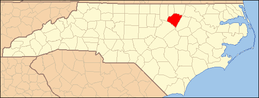 | |
| CDP | ||
| Unincorporated communities | ||
| Footnotes | ‡This populated place also has portions in an adjacent county or counties | |