Bunbury, Western Australia (suburb)
This article is about a suburb. For the metropolitan area, see Bunbury, Western Australia. For the local government area, see City of Bunbury.
| Bunbury Bunbury, Western Australia | |||||||||||||
|---|---|---|---|---|---|---|---|---|---|---|---|---|---|
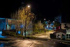 A nightscape of Bunbury Regional Library (Left) looking toward Victoria St. Bunbury Tower is visible in the background. | |||||||||||||
 Bunbury | |||||||||||||
| Coordinates | 33°20′24″S 115°38′21.2″E / 33.34000°S 115.639222°ECoordinates: 33°20′24″S 115°38′21.2″E / 33.34000°S 115.639222°E | ||||||||||||
| Population | 3,629 (2011)[1] | ||||||||||||
| • Density | 806/km2 (2,089/sq mi) | ||||||||||||
| Postcode(s) | 6230 | ||||||||||||
| Area | 4.5 km2 (1.7 sq mi) | ||||||||||||
| Location | 175 km (109 mi) SSW of Perth | ||||||||||||
| LGA(s) | City of Bunbury | ||||||||||||
| State electorate(s) | Bunbury | ||||||||||||
| Federal Division(s) | Forrest | ||||||||||||
| |||||||||||||

Victoria Street
Bunbury is a suburb of the city of Bunbury, and includes the city's central business district (CBD). The CBD is located primarily on Victoria Street. Blair Street is the major road linking the southern and eastern suburbs of Bunbury to the CBD, and has a large number of businesses and retail outlets situated along it.
Features

Bunbury's lighthouse and Marlston Hill's lookout tower
- Bunbury Tower, a landmark high-rise building, was one of the first achievements of the South West Development Commission and represents efforts to decentralise government activities and provide local employment opportunities.[2] The Tower is colloquially referred to as the "Milk Carton" for its distinctive shape and blue-and-white colours.
- The old lighthouse and lookout tower in the Marlston Hill district, which has been a focus of the city's cultural and commercial growth since the late 1990s.
References
- ↑ Australian Bureau of Statistics (31 October 2012). "Bunbury, WA (State Suburb)". 2011 Census QuickStats. Retrieved 16 April 2016.
- ↑ "Bunbury Tower". Heritage Council of WA. Retrieved 16 April 2016.
This article is issued from Wikipedia - version of the 8/22/2016. The text is available under the Creative Commons Attribution/Share Alike but additional terms may apply for the media files.