Bulmer, North Yorkshire
| Bulmer | |
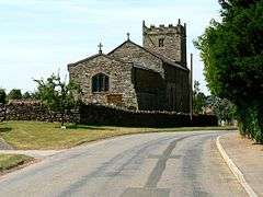 St Martins Church, Bulmer |
|
 Bulmer |
|
| Population | 202 |
|---|---|
| OS grid reference | SE699676 |
| Civil parish | Bulmer |
| District | Ryedale |
| Shire county | North Yorkshire |
| Region | Yorkshire and the Humber |
| Country | England |
| Sovereign state | United Kingdom |
| Post town | YORK |
| Postcode district | YO60 |
| Police | North Yorkshire |
| Fire | North Yorkshire |
| Ambulance | Yorkshire |
| EU Parliament | Yorkshire and the Humber |
| UK Parliament | Thirsk and Malton (formerly Ryedale) |
Coordinates: 54°06′00″N 0°55′55″W / 54.099950°N 0.932000°W
Bulmer is a village and civil parish in the Ryedale district of North Yorkshire, England. According to the 2001 census it had a population of 174, increasing to 202 at the census 2011.[1] The village is about seven miles south-west of Malton.
History
Bulmer was the seat of the ancient wapentake of the same name. The name Bulmer comes from "bull mere," a lake frequented by a bull.
The Bulmer family take their name from Bulmer. Ansketil de Bulmer is the first recorded member of the Bulmer family, who lived in the area in the twelfth century. The village is mentioned in the Domesday Book. It is recorded in 1066 as belonging to a Northmann and Ligulf. Tenancy was awarded by the King to Count Robert de Mortain, who passed the Lordship to Nigel Fossard.[2] By the nineteenth century the lordship of the manor had passed to the Earls of Carlisle, whose residence was at nearby Castle Howard. A monument to George William Frederick Howard can be found on top of Bulmer Hill just outside the village.[3]
Governance
The village lies within the Thirsk and Malton UK Parliament constituency. It is also within the Hovingham and Sheriff Hutton electoral division of North Yorkshire County Council.[4] It is part of the Derwent ward of Ryedale District Council.[5]
Geography
The village is situated two miles west of the A64 and 6.13 miles (9.87 km) south-west of Malton at an elevation of around 263 feet (80 m) above sea level. The nearest settlements are Welburn 1.5 miles (2.4 km) to the west; Sheriff Hutton 3.09 miles (4.97 km) to the east; Terrington 2.88 miles (4.63 km) to the north-east and Whitwell-on-the-Hill 1.78 miles (2.86 km) to the south-east.[4]
To the west of the village is Bulmer Beck that runs southwards to eventually join the River Derwent.
In the late nineteenth century the population was recorded as 231, which has decreased to 174 according to the 2001 UK Census.[3] Of the total population, 143 were over the age of sixteen, with 77 in full-time employment. The 2001 UK Census showed that there were 78 dwellings in the village.[6]
Village amenities
Visually, the village has changed little during history; however the small village school at the bottom of School Lane is now the village hall. The village also used to be home to a pub, blacksmith, shop and agricultural engineering workshop; these are all now closed.
Primary education can be found in the nearby villages of Sheriff Hutton, Welburn, Terrington and Thornton-le-Clay. Secondary Education can be found at Malton School or Norton College.
Religion
Bulmer church, originating from around the 10th century, still remains and services are held once every Sunday; the church also contains the last remaining tablet of a Methodist chapel, which used to be present in the village.
There is a church in the village, dedicated to St Martin, a soldier saint and Bishop of Tours. There used to be a Methodist Chapel in the village that built around 1842.[3]
References
- ↑ "Parish population 2011". Retrieved 11 August 2015.
- ↑ Bulmer in the Domesday Book Retrieved 17 November 2012.
- 1 2 3 Bulmer's Topography, History and Directory (Private and Commercial) of North Yorkshire 1890. S&N Publishing. 1890. pp. 654, 655. ISBN 1-86150-299-0.
- 1 2 Ordnance Survey Archived 5 October 2012 at the Wayback Machine.
- ↑ "Councils". Retrieved 17 November 2012.
- ↑ "Census stats". Retrieved 17 November 2012.
External links
![]() Media related to Bulmer, North Yorkshire at Wikimedia Commons
Media related to Bulmer, North Yorkshire at Wikimedia Commons