Lake Lanier
| Lake Lanier | |
|---|---|
 | |
| Location | Georgia |
| Coordinates | 34°14′14″N 83°56′10″W / 34.23722°N 83.93611°WCoordinates: 34°14′14″N 83°56′10″W / 34.23722°N 83.93611°W |
| Type | reservoir, from 1956 |
| Primary inflows | Chattahoochee River, Chestatee River |
| Primary outflows | Chattahoochee River |
| Catchment area | 1,040 sq mi (2,700 km2) |
| Basin countries | United States |
| Surface area | 37,000 acres (150 km2) 59 square miles |
| Max. depth | 256 feet (78 m) |
| Water volume | 1,049,400 acre·ft (1.2944 km3) |
| Surface elevation |
1,071 ft (326.4 m) summer 1,070 ft (326.1 m) winter |
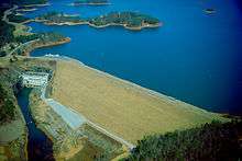
Lake Lanier (officially Lake Sidney Lanier) is a reservoir in the northern portion of the U.S. state of Georgia. It was created by the completion of Buford Dam on the Chattahoochee River in 1956, and is also fed by the waters of the Chestatee River. The lake encompasses 38,000 acres (150 km2) or 59 square miles of water, and 692 miles (1,114 km) of shoreline at normal level, a "full summer pool" of 1,071 feet (326 m) above mean sea level. Named for American poet Sidney Lanier, it was built and is operated by the U.S. Army Corps of Engineers for flood control and water supplies. It is patrolled by the Georgia Department of Natural Resources (GDNR), as well as local law enforcement.
The states of Georgia, Alabama and Florida all have rights to the water of the reservoir, as it feeds rivers going through those areas. The Corps of Engineers has responsibilities to regulate flow for flood control and water use. In addition, it has to ensure that water is available to fulfill such federal mandates as under the Endangered Species Act, to support downstream species. The rapid suburbanization of the Atlanta region, in particular, has greatly increased water consumption by private homeowners for lawns and gardens. During droughts of the 21st century, Lake Lanier reached record lows, and regional actions have been needed to reduce area water usage.
Geography
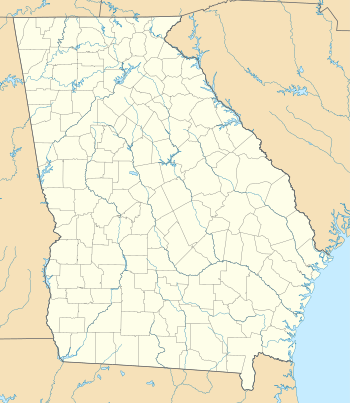
The lake is in Hall, Forsyth, Dawson, Gwinnett, and Lumpkin counties, split about 60%, 30%, 5%, 4%, and 1% respectively, filling the valley into numerous small arms and fingers. The former thalweg of the Chestatee and the Chattahoochee south of it form the county line between Hall and a corner of Gwinnett to the east, and Dawson and Forsyth counties to the west.
One of the main purposes of the lake is flood control of the Chattahoochee River downstream, mainly protecting metro Atlanta. Since the construction of Buford Dam, there have been only three major flooding events on the downstream section. The most severe flooding event was in 2009, following a two-year drought; the most recent was in 2013.
Reservoir
The lake's original purposes were to provide hydroelectricity, navigation, and flood control of the Chattahoochee River, and water supply for the city of Atlanta.
The $1 billion project was approved, with ground breaking in 1950. Approximately 700 families were moved from the area after their properties were bought by the USCOE, in order to flood the area and create the lake. A stretch of Georgia Highway 53 had to be abandoned that ran too close to the planned shoreline. Gainesville's Looper Speedway was also condemned and abandoned.[1]
More than $2 million had been spent by the Corps on preliminary construction when the House Committee on Appropriations refused to provide more funds in June 1951. During that summer Atlanta mayor William Hartsfield traveled to Washington numerous times pressing southern Democratic Senators Richard Russell, Jr. and Walter F. George to restore funding to ensure Atlanta's water supply during droughts.[2] Hartsfield returned to Washington in 1955 to lobby for $11 million more for the dam, which had a target date of 1956, again stressing the importance of an adequate water supply for his growing city. Congress approved the funds, and the dam was completed and opened on schedule.[3]
Lake Lanier began filling in 1956, and in 1957, 20 miles downstream, Morgan Falls Dam was raised to regulate the flow from Buford Dam and regulate the flow of water to Atlanta.[4] In early fall of 1958, the region had two solid months of drought, which would have left the Chattahoochee and its tributaries nearly dry, if not for the construction of Buford Dam and the reserve of Lake Lanier.[5]
Since the 1990s, the Corps of Engineers, Florida, Georgia, and Alabama have all been fighting for use of the water held in Lake Lanier. Federal law mandates that when a river flows between two or more states, each state has a right to an equal share of the water. Additionally, laws such as the Endangered Species Act require that water be available to preserve and support the threatened or endangered species that live in or around Chattahoochee River and Apalachicola Bay.
Drought 2007-2009
In June 2006, the USACE revealed that the new lake gauge at the dam, replaced in December 2005, was not properly calibrated, yielding a lake level reading nearly two feet (over half a meter) higher than the actual level. Because of this, nearly twenty-two billion U.S gallons (over eighty-two billion liters) of excess water had been released. This was above the already planned excess releases to support the successful spawning of gulf sturgeon in the Apalachicola River and to protect several species of mussels in Apalachicola Bay from excessive saltwater intrusion.
Georgia Governor Sonny Perdue said that the Corps had created a "manmade drought", because most of the state was already having dry conditions. This came at a time when outdoor water-use restrictions were being put in place by local governments. The high rate of suburban growth in the area resulted in a high rate of water consumption to care for the many lawns which had replaced forests. Because of the error in managing Lake Lanier, the governor's office declared a drought and enacted a ban on outdoor water use from 10AM to 4PM, in addition to the permanent weekly odd/even address system. Other local counties imposed further restrictions or total bans, based on each water system's conditions. Outdoor watering was banned completely as the state suffered its worst drought in its recorded history.
On October 16, 2007, Governor Perdue gave the USACE until the evening of October 17 to come up with a plan for the continued release of water for Florida wildlife. Senator Johnny Isakson stood before the Georgia General Assembly saying, "The health, safety and welfare of people are threatened. They are threatened by an act this Congress passed that had no intention to threaten them." He eventually withdrew his threat to sue the Corps of Engineers, but the Lake Lanier Association indicated that it would file a private legal action. Governor Perdue's attempts to reach an agreement with Florida over water releases fell through, leaving the final decision on releases from the lake to be made by the U.S. Fish and Wildlife Service.
On November 22, 2007 the water level was at 1,052.34 feet (320.75 m),[6] setting a new record low (see below: Lake water levels & External links). The previous low was 1,052.7 ft (320.9 m), set in December 1981.[7] The water level as of November 28, 2007 had dropped to 1,051.98 feet (320.64 m) and still decreasing at 0.05 ft (15 mm) a day.[6] One month later, the water level stabilized around a final low of 1,050.79 ft (320.28 m), recorded December 26, 2007 at Buford Dam. The day after Christmas, the water level began rising from week to week.[8]
Eventually after winter rains, on February 18, 2008, the water level of Lake Lanier rose to 1,052.80 ft (320.89 m),[8] higher than the December 1981 level of 1,052.7 ft (320.9 m), effectively ending the record-low phase of the drought crisis.
A similar drought situation occurred in late 2008. At the end of the year, the water level stabilized around a final low of 1,051.00 ft (320.34 m), recorded December 8, 2008, at Buford Dam, slightly above the record set in 2007.
After rainfall during the winter of 2008-2009, on March 30, 2009, the climatologist of the state of Georgia, David Stooksbury, declared the drought over,[9] noting, "soil moisture is near normal, stream flows are near normal. Small and medium-sized reservoirs are full." Stooksbury continued, "There is still the 500-pound gorilla sitting in the room and that’s Lanier." In May 2009, the water level of Lake Lanier rose to exceed 1066 ft, reaching a high of 1,066.71 ft (325.13 m) in mid-June 2009. It did not reach the full summer pool of 1071 ft during mid-2009, remaining more than 4 ft (1.2 m) lower. Following weeks of heavy rain in North Georgia, Lake Lanier returned to full pool in mid-October 2009. The record high is 1,077.2 feet (328.3 m) set in April 1964.
The record-low lake levels had revealed parts of the lake bottom not seen since the 1950s, including remnants of a road and foundations of homes that had to be abandoned for the construction. More recent additions to the lake - including discarded trash, boat batteries and sunken boats - were discovered. Local efforts were organized to clean up the lake bottom. Several automobiles, some stolen, and discarded firearms were also recovered by law enforcement officials.[1]
Lawsuits
In July 2009, a federal judge from Minnesota (chosen from a neutral location as an arbiter) ruled that Congress never authorized Lake Lanier to be used as a source of the water supply for metro Atlanta. Georgia was given three years to stop withdrawing from the lake (except for the adjacent cities of Gainesville and Buford), unless Congress authorized it, or if it and the other two states using water from the reservoir came to agreement about use. The Atlanta Regional Commission chairman noted that if enforced, cutting drinking water to 75% of current users in the region would require disaster aid from the Federal Emergency Management Agency (FEMA).
Recreation

The lake is popular with boaters, houseboats, jetskiers and others, particularly around the summer holidays. Over 7.5 million people per year visit the lake, including its marinas and the Lake Lanier Islands waterpark. The rowing and sprint canoeing events during the 1996 Summer Olympics were held at the lake.[10][11] It also hosted the canoe sprint World Championships in 2003 at the Lanier Canoe and Kayak Club.
One resort hotel sits on the lake: Legacy Lodge (Formerly Emerald Pointe Hotel). A second hotel, Pine Isle was recently demolished. Both were sold by CNL Hotels & Resorts, a hotel investment firm in Florida, to Georgia businessman Virgil Williams. Both assets sit on a ground lease from the Lake Lanier Islands Development Authority which in turn leases the land from the U.S. Army Corps of Engineers.
Established in 1957, Holiday Marina has become synonymous with Lake Lanier. Holiday Marina in Buford, Georgia, and Aqualand Marina near the town of Flowery Branch, are two of the largest freshwater marinas in the world.
Lake Lanier was the site of the 1997 Bilderberg conference.
Every year from mid-November through January, Lake Lanier Islands are decorated with over 6 miles (9.7 km) of Christmas lights, the largest animated light show in the southeast and one of the world's largest light shows. Magical Nights of Lights is an animated drive-through display that ends with a Christmas village, carnival rides, bonfire, Santa Shop, live nativity, etc.
Effects of 21st century droughts
At the end of 2007, the water level of Lake Lanier became notable, on a daily basis, for setting record low levels, worse than any in the previous 25 years. By early November, the water level was dropping a fifth of a foot (.06 m) per day (see table below), with the largest drop on November 9 of 0.26 ft (0.08 m) to 1054.08 ft (321.4 m).[8]
The dropping water level slowed to 0.05 ft (0.02 m), as measured on November 17, 2007, after local rains continued and the water flow had been reduced at Buford Dam. However, water levels continued to decline almost daily during the month of December 2007 (see table below; December record low levels in bold-face font).
| Water levels at Lake Lanier.[8] | ||||
|---|---|---|---|---|
| Day |
Oct 2007 |
Nov 2007 |
Dec 2007 |
Jan 2008 |
| 1 | 1058.73 | 1055.46 | 1051.75 | 1051.31 |
| 2 | 1058.65 | 1055.36 | 1051.69 | 1051.29 |
| 3 | 1058.55 | 1055.28 | 1051.66 | 1051.28 |
| 4 | 1058.43 | 1055.19 | 1051.60 | 1051.28 |
| 5 | 1058.37 | 1054.99 | 1051.55 | 1051.27 |
| 6 | 1058.30 | 1054.80 | 1051.48 | 1051.27 |
| 7 | 1058.25 | 1054.55 | 1051.40 | 1051.26 |
| 8 | 1058.12 | 1054.34 | 1051.36 | 1051.19 |
| 9 | 1058.05 | 1054.08 | 1051.34 | 1051.21 |
| 10 | 1057.90 | 1053.99 | 1051.27 | 1051.18 |
| 11 | 1057.74 | 1053.93 | 1051.22 | 1051.25 |
| 12 | 1057.52 | 1053.71 | 1051.15 | 1051.28 |
| 13 | 1057.44 | 1053.52 | 1051.08 | 1051.28 |
| 14 | 1057.35 | 1083.29 | 1051.02 | 1051.27 |
| 15 | 1057.12 | 1053.07 | 1051.02 | 1051.26 |
| 16 | 1056.93 | 1052.87 | 1050.99 | 1051.33 |
| 17 | 1056.77 | 1052.82 | 1050.95 | 1051.31 |
| 18 | 1056.53 | 1052.76 | 1050.91 | 1051.37 |
| 19 | 1056.39 | 1052.62 | 1050.87 | 1051.38 |
| 20 | 1056.34 | 1052.49 | 1050.82 | 1051.41 |
| 21 | 1056.27 | 1052.33 | 1050.86 | 1051.38 |
| 22 | 1056.20 | 1052.23 | 1050.83 | 1051.42 |
| 23 | 1056.16 | 1052.12 | 1050.84 | 1051.47 |
| 24 | 1056.11 | 1052.07 | 1050.87 | 1051.44 |
| 25 | 1056.03 | 1052.02 | 1050.81 | 1051.42 |
| 26 | 1055.91 | 1052.01 | 1050.79 | 1051.42 |
| 27 | 1055.87 | 1051.97 | 1050.80 | 1051.42 |
| 28 | 1055.80 | 1051.91 | 1050.94 | 1051.41 |
| 29 | 1055.75 | 1051.86 | 1051.03 | 1051.41 |
| 30 | 1055.63 | 1051.81 | 1051.24 | 1051.47 |
| 31 | 1055.55 | 1051.32 | 1051.49 | |
| New low levels are shown bolded. Record lows are dated 1 day later than table, adding "0.01" foot. (Surface elevation in feet, divide by 3.28 for metres) | ||||
Further rains during November and December stabilized the water level at a low of 1,050.79 ft (320.3 m) on December 26, 2007, with the water level fluctuating up/down by about 0.03 ft (0.009 m) daily (see table at right). On December 27, the water level began rising above the record low level, but fluctuating every few days, as affected by further rain and snow during December and January 2008. By the end of December 2007, the water level had risen more than six inches (.3 m) to 1,051.32 ft (320.4 m), rising more than 3 times faster than it had recently dropped. It reversed more than 18 days of losses within 5 days (see table).
Finally, on February 18, 2008, the water level of Lake Lanier had risen above the record-low levels set in November, rising to 1,052.80 ft (320.89 m).[8] This was higher than the December 1981 level of 1,052.7 ft (320.9 m), effectively ending the record-low phase of the drought crisis. As of April 21, 2009, the lake had risen back to 1063.39 feet.
Multiple rain storms further to the south, along the Chattahoochee River to Apalachicola Bay, brought increased fresh water to the Florida wildlife in November and December 2007, despite the reduced water flow from Lake Lanier at Buford Dam. Rainfall along the lower Chattahoochee River was often greater overall than above Lake Lanier, as it spanned the longer length of the river.
Metropolitan Atlanta received far above-average rainfall amounts throughout September and October 2009, and had record floods. On October 14, 2009, Lake Lanier had risen back to above-full pool at 1071.01 feet. The record high is 1,077.2 feet (328.3 m), set in April 1964.
In 2011 and 2012 the water fell to some of the lowest points on record set during the 2007 droughts. In the spring and summer of 2013, the water level reached some of the highest points due to high amounts of rain and flooding in the north Georgia area. By late June 2016, the southern parts of Forsyth County were having severe drought, and water use was ordered to be conserved.[12]
References
- 1 2 Associated Press, Jacksonville News
- ↑ Martin, Herald, William Berry Hartsfield, UGA Press, 1978, p. 87
- ↑ Martin, Herald, William Berry Hartsfield, UGA Press, 1978, p. 111
- ↑ Martin, Herald. Atlanta and Environs, Vol III, UGA Press, 1987, p. 260
- ↑ Martin, Herald. Atlanta and Environs, Vol III, UGA Press, 1987, p.294
- 1 2 http://www.srh.noaa.gov/ffc/html/rrm.php
- ↑ http://lanier.sam.usace.army.mil/faqs.htm
- 1 2 3 4 5 "Midnight Pools at Buford" (Lake Lanier daily water levels), December 2007, USACE, webpage: ACF-prob1.
- ↑ http://www.ajc.com/metro/content/metro/stories/2009/03/30/atlanta_drought_over.html
- ↑ 1996 Summer Olympics official report. Volume 1. p. 541.
- ↑ 1996 Summer Olympics official report. Volume 3. pp. 452, 460.
- ↑ Kayla Robins, "Lake Lanier levels concerning for drought", Forsyth County News, 29 June 2016; accessed 25 July 2016
External links
![]() Media related to Lake Lanier at Wikimedia Commons
Media related to Lake Lanier at Wikimedia Commons
- "Growth, growth everywhere but not a drop to drink" News article about the 2007-08 drought
- Lake Lanier daily water levels (measured and posted daily by USACE at Buford Dam): http://water.sam.usace.army.mil/gage/acf/prob1.txt
- Lake Lanier Protection Group
- Lake Lanier News
- Lake Lanier Information
- Lake Lanier - US Army Corps of Engineers
- Lake Lanier Statistics & Historical Data
- Lake Lanier Convention & Visitors Bureau
- Lake Lanier Rowing Club
- Lanier Canoe and Kayak club
- Current Lake Lanier Water Level
- Lake Lanier Olympic Venue
- Lake Lanier History
_pictogram.svg.png)
