Buffalo River (Minnesota)
| Buffalo River | |
|---|---|
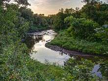 The Buffalo River in Buffalo River State Park | |
| Country | United States |
| Basin | |
| Main source | Tamarack Lake |
| River mouth |
Red River of the North near Georgetown, Minnesota 853 feet (260 m)[1] |
| Basin size | 1,189 square miles (3,080 km2) |
| Physical characteristics | |
| Length | 139 miles (224 km) |
The Buffalo River is a 139-mile-long (224 km)[2] tributary of the Red River of the North in western Minnesota in the United States. Via the Red River, Lake Winnipeg and the Nelson River, it is part of the watershed of Hudson Bay. The river drains an area of 1,189 square miles (3,080 km2).
Course
The Buffalo River flows from Tamarack Lake in the Tamarac National Wildlife Refuge in central Becker County and flows generally westwardly into Clay County, past the towns of Hawley and Georgetown and through Buffalo River State Park. It flows into the Red River about 1 mile (2 km) west of Georgetown.
The river's largest tributary is the 71.8-mile-long (115.6 km)[2] South Branch Buffalo River, which rises in western Otter Tail County and flows initially westward into northern Wilkin County, then northward into Clay County. It joins the main stem of the river near Glyndon, Minnesota.[3]
See also
Coordinates: 47°05′17″N 96°48′58″W / 47.0880232°N 96.8161908°W[4]
References
- ↑ "Geographic Names Information System". U.S. Geological Survey. 1980-01-11. Retrieved 2012-11-22.
- 1 2 "National Hydrography Dataset high-resolution flowline data". U.S. Geological Survey. Archived from the original on 2012-04-05. Retrieved 2011-06-08.
- ↑ "A Management Plan for Buffalo River State Park". Minnesota Department of Natural Resources. 1980.
- ↑ U.S. Geological Survey Geographic Names Information System: Buffalo River
- Waters, Thomas F. (1977). The Streams and Rivers of Minnesota. Minneapolis: University of Minnesota Press. ISBN 0-8166-0960-8.