Buena Vista Oil Field
The Buena Vista Oil Field, formerly the Naval Petroleum Reserve No. 2 (NPR-2) is a large oil field in Kern County, San Joaquin Valley, California in the United States. Discovered in 1909, and having a cumulative production of approximately 667 million barrels (106,000,000 m3), it is the tenth-largest oil field in California. It is also one of the closest to being exhausted, having a total reserve of only about one percent of its original oil, and having produced a mere 713,000 barrels (113,400 m3) in 2006.[1]
Setting
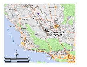
The oil field is in two parts, the Buena Vista Hills Area and the Buena Vista Front Area, both roughly linear features about 12 miles (19 km) long, running parallel about two miles (3 km) apart, and each being one to two miles (3 km) across, and trending from southeast to northwest. The town of Taft is adjacent to the southwest, about halfway along the field. The oil field underlies the Buena Vista Hills, a low range with a maximum elevation of 1,300 feet (400 m), in their entirety, and the Buena Vista Front Area is mostly in the Buena Vista Valley, which separates the Buena Vista Hills from the larger Elk Hills range to the north. State Route 33 parallels the Buena Vista Field about two miles (3 km) to the southwest, and State Route 119 cuts across the field to the northeast, towards Bakersfield.
Many oil fields underlie the southwestern portion of Kern County. Adjacent to the Buena Vista field to the southwest is the enormous Midway-Sunset Oil Field, the largest in California and third-largest in the United States, and just north of the Buena Vista field is the Elk Hills Oil Field, famous for the Teapot Dome scandal as one of the illicit leases that brought corruption charges upon the administration of Warren G. Harding.
Until January 1, 1958, the Buena Vista field was considered to be part of the larger Midway-Sunset Field to the southwest; now, however, the two are considered to be geologically separate.[2]
Geology and production

As with many of the fields in the San Joaquin Valley, the Buena Vista field is predominantly an anticline, with pools of oil trapped in rock units beneath impermeable layers. Some of the oil pools are in domes and anticlinal formations, and others are trapped in rock units due to movement of faults. The age of most of the rock units containing oil varies from Pliocene (Etchegoin Formation), the most recent, to Miocene (Monterey and Santa Margarita Formations), the most ancient, and oil has been recovered at depths from about 2,300 feet (700 m) to 5,300 feet (1,600 m). The deepest well on the field was drilled by the Honolulu Oil Corp. to a depth of 14,622 feet (4,457 m), reaching the Santos unit of Oligocene age. No economically recoverable oil was found at this depth.[2]
In the Front Area, the less productive part of the oil field, most of the oil comes from depths of around 4,000 feet (1,200 m), from the San Joaquin and Etchegoin formations. These pools were discovered in 1912, peak production was in 1925, waterflooding was attempted in the 1960s, and with most of the oil having been removed, today most operations have ceased. The Main Area of the Buena Vista Oil Field is still active, with enhanced recovery technologies such as gas injection still continuing. Peak production in the Main Area was in 1947, and has fallen off steadily since.[3]
Most of the oil produced from the Buena Vista field is medium crude, with specific gravity of approximately 18 to 36 API. One of the geologic units, the "Mya Gas", discovered in 1909, produces only natural gas; its year of peak production was 1919. The discovery well for the field was in this unit, and it was the abundant presence of natural gas that convinced drillers to keep looking, as where gas was found, typically oil would be as well.
While much of the field has been abandoned, there is at least one active prospect adjacent to the old field. An Australian company, Salinas Energy, is currently studying the possibility of commencing production. [4]
References
- California Oil and Gas Fields, Volumes I, II and III. Vol. I (1998), Vol. II (1992), Vol. III (1982). California Department of Conservation, Division of Oil, Gas, and Geothermal Resources (DOGGR). 1,472 pp. Midway-Sunset information pp. 48-54. PDF file available on CD from www.consrv.ca.gov.
- California Department of Conservation, Oil and Gas Statistics, Annual Report, December 31, 2006.
- Salinas Energy: Description of the South Buena Vista Prospect
Notes
- ↑ California Department of Conservation, Oil and Gas Statistics, Annual Report, December 31, 2006, p. 2
- 1 2 DOGGR, California Oil and Gas Fields, p. 50
- ↑ DOGGR, California Oil and Gas Fields, pp. 48-54
- ↑ Salinas Energy: Description of the South Buena Vista Prospect Archived September 3, 2007, at the Wayback Machine.
External links
Coordinates: 35°11′11″N 119°25′49″W / 35.1865°N 119.4304°W