Buckhorn Draw Pictograph Panel
| Buckhorn Draw Pictograph Panel | |
|---|---|
 | |
 | |
| Location | Emery County, Utah, USA |
| Nearest city | Castle Dale |
| Coordinates | 39°07′25″N 110°41′37″W / 39.12361°N 110.69361°WCoordinates: 39°07′25″N 110°41′37″W / 39.12361°N 110.69361°W |
| Governing body | Bureau of Land Management |
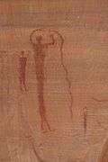
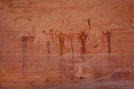
The Buckhorn Draw Pictograph Panel is an example of rock art, located in Buckhorn Draw in the San Rafael Swell in central Utah, approximately four miles north of the San Rafael campground and bridge.
Primarily a Barrier Canyon Style panel, there are a few later petroglyphs of Fremont culture origin as well. In many cases the Fremont painted figures on top of the older Barrier Canyon ones.
The route up Buckhorn Draw was part of the Old Spanish Trail. As a result of the relatively large number of people passing by, the panel was repeatedly vandalized and marked with graffiti over the years. In 1996 the State of Utah and Emery County restored the panel as part of the state's centennial celebration.
|


External links
 Media related to Buckhorn Draw Pictograph Panel at Wikimedia Commons
This article is issued from Wikipedia - version of the 11/19/2016. The text is available under the Creative Commons Attribution/Share Alike but additional terms may apply for the media files.