Brumado
| Brumado | |||
|---|---|---|---|
| Municipality | |||
| The Municipality of Brumado | |||
|
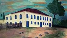
Image of the center and neighborhood of São Félix. | |||
| |||
|
Nickname(s): Capital do minério, Brumas, BDO | |||
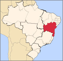
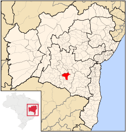 Location of Brumado | |||
 Brumado Location in Brazil | |||
| Coordinates: 14°12′13″S 41°39′55″W / 14.20361°S 41.66528°WCoordinates: 14°12′13″S 41°39′55″W / 14.20361°S 41.66528°W | |||
| Country |
| ||
| Region | Northeast | ||
| State | Bahia | ||
| Mesorregion | Mesorregião do Centro-Sul Baiano | ||
| Microrregion | Microrregion of Brumado | ||
| Founded | Juny 11, 1877[1] | ||
| Government | |||
| • Mayor | Aguiberto Lima Dias Democratic Labour Party (PDT) | ||
| Area | |||
| • Municipality | 2,207.612 km2 (852.364 sq mi) | ||
| • Urban | 2,174 km2 (839 sq mi) | ||
| Elevation | 454 m (1,490 ft) | ||
| Population (2016) | |||
| • Municipality | 69 473 | ||
| • Density | 29,01/km2 (7,510/sq mi) | ||
| Time zone | Brasilia Official Time (UTC-3) | ||
| • Summer (DST) | Brazilian Daylight Saving Time (UTC-2) | ||
| Postal Code | 46100-000 | ||
| Area code(s) | +55 77 | ||
| Website | oficial website | ||


Brumado is a Brazilian municipality in the interior of Bahia, in the Northeast region of the country, precisely in the mesoregion of the Center-South of the State, in the homonymous microregion, 555 kilometers from the state capital, Salvador. Its territorial area is 2 207,612 square kilometers, the headquarters`s area occupyin 2 174 square kilometers, have altitude of 454 meters. According to data from the Brazilian Institute of Geography and Statistics (IBGE), in 2016 its population was estimated at 69 473 inhabitants. The Human Development Index (HDI) is 0.656 (average).[1]
A survey by the Federation of Industries of the State of Rio de Janeiro (FIRJAN) found that Brumado is considered to be the sixth most developed municipality in Bahia, based on the FIRJAN Municipal Development Index (IFDM 2013) published in 2015.[2] A query made exclusively by Urban Systems, in January 2016, for Exame Magazine, concluded that the city is among the 100 best in Brazil to invest, ranking 84th in the ranking, totaling 2 306 points.[3] A study carried out by IBGE, in 2012, concluded that of the 64 602 inhabitants, 50 899 were literate, 31 747 were men and 32 855 were women. The per capita income was R$ 12,144.11, and in distribution between rural and urban areas, in the private households in the rural area, it was R$ 217.00, and in the urban area it was R$ 333.33. The fleet of motor vehicles, such as road transport, including motorcycles, as well as tractors and trucks totaled 31 000.
The city is known as the "Ore Capital" because it has a large amount of minerals in its subsoil, which is the basis of its economy and welcomes large mining companies that carry out their extractive activities in Serra das Éguas, which, by the way, also Is one of the tourist points of the county, to form mountainous landscapes.[4] Brumado has as boundary municipalities Livramento de Nossa Senhora, Dom Basilio, Aracatu, Rio de Contas, Malhada de Pedras, Tanhaçu, Ituaçu, Rio do Antônio, Lagoa Real and Caraíbas.[5] For making a border with the city of Rio de Contas through River that has that same name, consequently also makes currency with the Chapada Diamantina. The city has a privileged location allied to other benefits, such as important road junctions such as BA-262, BA-148 and BR-030, also counting on the Centro-Atlântica Railroad (FCA).[6]
History
- Etimology
There is no version defined on the origin of the name Brumado. According to Teodoro Fernandes Sampaio, the name "Brumado" originates in a tupi expression: Itimbopira (Y - timbó - pyra), which means misty, covered with haze. Already in the version of José Dias, a former priest of the region, the name originates from the Serra Geral and the Chapada Diamantina, which to the north, at dawn, descends from the misty mountains covering the city. In another version, the origin of the name Brumado or its Etimology, is attributed to the word bromo; A word which, at the time of the mining in the Brumado River, was used by the miners and bandeirantes to distinguish loss or deception, mystification or disappearance of the gold in the mining or stream that was supposed rich of that ore.[7][8][9]
Settlement
In the XVIII century, the bandeirante Francisco de Souza Meira and his team left the present municipality of Livramento de Nossa Senhora, crossing the Brumado River, advancing along the right bank until reaching the mouth of the Do Antônio River, arriving in indigenous territory, Tupinambás ferocious, and between them a great fight was fought, near the area where today it is the seat of the municipality of Brumado. It was the first part taken and was named "Conquest", then founded a farm called Serra das Éguas. Although these Indians strongly resisted the attacks of the captain and his group, they gradually dispersed, troubled by the presence of white men.[8]
In the future, Serra das Éguas farm was acquired by João Antunes Moreira, who in turn left for his son, Father André Antunes da Maia; who finally sold it on June 30, 1749 to José de Souza Meira, son of Francisco de Souza Meira, for $ 462,700 (1 million, 462 thousand and 700 réis), with 232 heads of cattle, 105 heads of equine cattle and a slave named Manuel. In this way, the lands returned to the hands of the Meiras. In 1755, Campo Seco farm was bought by the Portuguese Miguel Lourenço de Almeida (family of the Holy Office), a clan of the Canguçu family in the municipality. The Serra das Éguas farm was near the area that is today the city of Brumado. It was located on the south side, lower part of a mountain range, today called Serra das Éguas, known for the deposits of magnesite and mineral talc. Over the years, a small settlement grew more or less ten kilometers by the same margin of the river, thanks to the successes of the adventurers who worked hard to farm and To livestock, giving life to the town that would later be the seat of the municipality.[8]
Emancipation
When settled, Bom Jesus dos Meiras belonged to Livramento do Brumado (current Livramento de Nossa Senhora). On June 19, 1869, still under the name of Bom Jesus dos Meiras, the then vice president of the province of Bahia, Antônio Ledeslau de Figueiredo Rocha, signed Provincial Decree-Law No. 1091, thus transforming Bom Jesus dos Meiras in a district of the same name, annexing it to Caetité, who was already emancipated. Soon after, Antônio Pinheiro Pinto Canguçu, the second master of Sobrado do Brejo, contributed financially and with labor to build the Chapel of Bom Jesus, attending the requests of the inhabitants; Today, the old chapel is the mother church of Brumado, that at that time was called Church Senhor do Bonfim, in homage to the patron of the city, Bom Jesus, and had like first vicar the priest Jose Mariano Meira Rocha.[9] Bom Jesus dos Meiras separated from Caetité in 1877, receiving the title of village. The author of the project was a deputy from the province of Bahia, Marcolino Moura. The political leader at that time was Colonel Exupério Pinheiro Canguçu, the fourth and last lord of Sobrado do Brejo. Political emancipation occurred on June 11, 1877, with the creation of Provincial Law n ° 1756. The first City Council of Bom Jesus dos Meiras was created on February 13, 1878, composed of the following persons listed below and their Respective positions: President: Colonel Exupério Pinheiro Canguçu; Secretary: Belarmino Jacundes Lobo; Prosecutor: Rufiniano de Moura Amorim; Tax: Plácido Guedes d'Oliveira; Porter: Francisco Alves Piranha.[7][8][9]
In 1948, Armindo dos Santos Azevedo took office as the first mayor elected by direct vote. The merchant and cattle rancher was elected in three terms: 1948 - 1950, 1955 - 1958 and 1963 - 1966. In its management, the municipality achieved great advances, such as water supply, electricity and paving of many streets and squares in the city center. The energy in Brumado in the 1940s to 1970s only worked until 9:30 p.m. It was from then on that the energy began to function in an integral way.[10] In 1962, the districts of Santa Bárbara dos Casados, Olhos d'Água and São Pedro would have their toponyms changed to Ubiraçaba, Itaquaraí and Aracatu, respectively.[10] From 1967 to 1970, the mayor was elected doctor Juracy Pires Gomes, with the support of partner Armindo dos Santos Azevedo. In his mandate important works were carried out, such as the new city hall, the new municipal market, the city's first public library; The main one was the dam of the Do Antônio River that would supply the city until the year 2010.[9][10]
Economic Expansion
At the beginning of the XX century, the economy was based on agriculture: large-scale cotton farming, coffee and cereals, and cattle raising, goats, sheep and cattle, favoring the export of sheep skins raw or tanned, dry leather and salty, as well as lump cotton and live cattle. Cotton was the culture that most contributed to the economic development of the municipality. Between 1930 and 1955, the production was so great that the producers started to benefit it in the field even using handmade machines. Faced with the success of cotton growing, modern cotton factories were installed in the city. The municipality had six plants in operation. Since 1980, the crop has declined, due to several factors, as an interruption of financial aid by the government, (such as crop insurance), cotton boll weevil (pests that destroy crops), high interest rates for production financing, and of the processing.[11][12][13] Currently, the production of passion fruit has been outstanding, in the district of Itaquaraí, one of the largest production locations in Brazil.[14]

In 1930, two important events marked the economic history of the municipality: the arrival of the mining company Magnesita S.A., founded by two French friends naturalized Brazilian and resident in Brazil, Miguel Pierre Cahen and Georges Louis Minviele - in partnership with Antônio Mourão Guimarães -, a politician of the time, and the construction of the Federal Railroad Network (RFFSA), which would facilitate the transportation of the newly discovered ore to the port of Aratu in Salvador. Both events occurred in 1939. The Magnesita company was authorized to operate in 1940 through Decree nº 6220 and since then, it has exploited most of the magnesite and mineral talc reserves contained in Serra das Éguas. In the 1970s Brumado arrived at the Brazilian Refractory Products Industries (IBAR S.A.). The company interested in extracting magnesite has established its facilities in the northern part of the saw. In the following years, the municipality witnessed great changes, such as large-scale population growth, construction of houses and commercial establishments. Faced with this great attraction, people from other cities were arriving, commerce strengthened, and the city of Brumado became known by recent events. To the south of the former Serra das Éguas farm was formed a kind of closed condominium: the village Catiboaba; The Presidente Getúlio Vargas village was also formed around the company, fruit of the flow of workers who came from the most varied places to work in the mines of magnesite and mineral talc.[10][15][16] In 1969, it was the turn of Xilolite S.A., which also settled on the north side of the mountain range and has since exploited magnesite and mineral talc, with the acquisition of one of the mines in 1973.[17] In 1993, Matsulfur, a cement factory, later acquired by Lafarge, under the name Cement Brumado, today Cimpor (Cement of Portugal), belonging to InterCement (Grupo Camargo Corrêa).[18][19]
Geography
The municipality of Brumado is located in the Center South (or Southwest) of Bahia, in the region known geographically as the Polygon of the Droughts, in Serra Geral, under the coordinates: 14 ° 12 '13 ", south latitude; 41 ° 39 '55 "west longitude, at 454 meters altitude and is 555 kilometers southwest of Salvador. The urban area covers an area of 2 174 square kilometers.[20] There is no information if there is a point higher than the Serra das Éguas peak, probably this is the highest point of the municipality, with 1 100 meters.[15][21][22] The municipality limits with Livramento de Nossa Senhora and Dom Basilio, to the north; Rio de Contas, Ituaçu and Tanhaçu, to the northeast; Aracatu, to the east; Rio do Antônio and Lagoa Real, to the west; Malhada de Pedras to the southwest and the Caraíbas to the south. Its micro-region has a homonymous name. The urbanization rate is 69.86%, population density is 29.01 inhabitants per square kilometer.[1][5]
Relief and hydrography

The municipality of Brumado is characterized by mountainous formations typical of the Espinhaço Mountains (Serra do Espinhaço), which is the mountainous chain that occupies much of the southwest of the State and which belongs the relief of the municipality. The relief of Brumado is very bumpy, presenting mountainous areas denominated mountains and/or altomontanas, like the Mares sierra (Serra das Éguas) and Black stone hill (Morro da Pedra Preta).[23] There are also level areas, which are flat and / or wavy forms, which make the transition between the upper and lower areas, forming species of stairs. Also has flat and flat relief shapes.[24] In general, the Brumadian relief is quite rugged, slightly undulating and presents erosions due to the floods, favorable characteristics for biodiversity, contributing to a wide variety of species, both in flora and fauna.[25]

The municipality of Brumado is part of the De Contas River basin and the Of Antônio River sub-basin, which also includes the municipalities of Caculé, Rio do Antônio, Licínio de Almeida, Guajeru and Malhada de Pedras. The main drains of the Contas River basin are: Brumado River, São João River, Santa Maria Stream, Of Antônio River and Gavião River; The main tributaries of the Antônio River are: Paiol River, Salto River and Quirino Stream. The Antônio River Basin has an area of 6,540 square kilometers.[6][26] Two of the great tributaries are born in very different places: the Brumado River, affluent of the Contas, is born in the Saw of souls (Serra das Almas) and Do Antônio River in General Saw (Serra Geral), in the municipality of Licínio de Almeida.[6][27] In Of Contas River is inserted the dam of Cristalândia Which supplies the city, and in Antônio River, the dam of the Of Antônio River, which supplied the urban population by 2010.[28] Most rivers are temporary, such as Of Antônio River and São João River. The Of Contas River Basin has annual precipitation between 700 and 800 mm, with little possibility of major floods. The average temperature is 22° C. It is characterized by two biomes: Caatinga and Atlantic Forest (Mata Atlântica), which have suffered deforestation, to give way to agriculture and urbanization. It covers an area of 4 477.62 square kilometers. The municipality that most demands water from the basin is Jequié.[29] The sub basin of the Of Antônio River has suffered over time with water degradation, due to the intense pollution of its waters, deforestation of the riparian forests and the excess of dams that are built. The main drainage of the sub basin, the river of the same name, has as its main function human supply, with minimum use for irrigation.[6]
Geomorphology
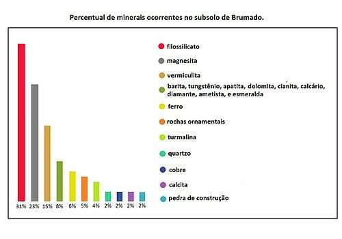
Geologically, Brumado is located in the São Francisco Craton, precisely in the Gavião Geological Block, in the Greenstone Belts Umburanas.[24][30] In these areas, the rocks are formed by metavulcanic sequences, that is to say of very old volcanic actions, which favored the formation of metamorphic rocks of a great quantity of minerals, metals and nonmetals such as iron, manganese, emeralds, quartz, granites and different types of ornamental stones.[30] The chart below shows the main occurrences of minerals in the Brumadian basin and their corresponding percentages. In geochronology studies it was verified that the oldest rock formations of South America, with the age of 3.4 to 3.5 billion years, are between the municipalities of Brumado and Vitória da Conquista. In the geological scale, the soil is from the Paleoproterozoic Age or the Lower Proterozoic Age, equivalent to 1.6 and 2.5 Gigaannum. It was at this age that the oldest rocks and the richest soils in any and every type of ore were formed. This explains why Serra das Éguas is so rich in minerals.[31] In addition to magnesite, Brumadian soil contains all these minerals already mentioned above, which leads us to conclude that it is one of the richest soils in Brazil and one of the oldest in the world, making it one of the most studied by geologists.[30]
Climate
The predominant climate in Brumado is the tropical steppe, making a transition with the semi-arid climate, classified as BSh (hot and dry), according to Wladimir Köppen and Rudolf Geiger, however, there are much lower temperatures at the top of the hills, always citing as an example the Éguas Saw and Pedra Preta Hill, one of the highest points of this mountain range. The rainy season is concentrated between October and January, with a difference of 128 mm between the driest month of August and the driest month of December. The rest of the year, the rains are scarce. The average temperature is 23.8 ° C, with an average annual rainfall of 590 to 600 mm.[4][32] same with the scarcity of rainfall, the city already suffered with excesses, as in 1968, when the Do Antônio River suffered a great flood at the point of water reaching the center of the city, after passing over the bridge of the São Félix neighborhood, which Was caught.[33][34] Other floods occurred in 1982 and 1992. It also suffered major droughts, as in 1998.[28][35] The months of January of the years of 2015 and 2016 were considered "good of rain", registering 350 mm and 530 mm, respectively, the latter almost reaching the annual average. The highest accumulated of that month happened in 1985, when it was registered more than 1 100 mm.[36] In the table below, one can more accurately understand the climatic effects in the municipality in a normal year.
| Climate data for Brumado | |||||||||||||
|---|---|---|---|---|---|---|---|---|---|---|---|---|---|
| Month | Jan | Feb | Mar | Apr | May | Jun | Jul | Aug | Sep | Oct | Nov | Dec | Year |
| Average high °C (°F) | 30.2 (86.4) |
30.6 (87.1) |
30.2 (86.4) |
29.5 (85.1) |
28.5 (83.3) |
28.8 (83.8) |
22.4 (72.3) |
28.7 (83.7) |
30.7 (87.3) |
31.6 (88.9) |
30.7 (87.3) |
29.9 (85.8) |
29.32 (84.78) |
| Daily mean °C (°F) | 19.4 (66.9) |
19.4 (66.9) |
19.5 (67.1) |
18.8 (65.8) |
17.2 (63) |
15.8 (60.4) |
15.1 (59.2) |
15.7 (60.3) |
17.4 (63.3) |
19.0 (66.2) |
19.4 (66.9) |
19.4 (66.9) |
18.01 (64.41) |
| Average precipitation mm (inches) | 78 (3.07) |
72 (2.83) |
43 (1.69) |
42 (1.65) |
07 (0.28) |
04 (0.16) |
03 (0.12) |
13 (0.51) |
08 (0.31) |
43 (1.69) |
122 (4.8) |
131 (5.16) |
566 (22.27) |
| Source: Climate[37] | |||||||||||||
Ecology and environment
Fauna and flora
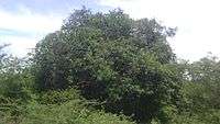

Along the municipality, there are four types of vegetation existing in all Brazilian territorial extent: Ciliar Forest, Cerrado, Rupestre Field and Caatinga, which is the predominant vegetation. In the ridges of the hills and mountains, such as Das Éguas Saw and Da Pedra Preta Hill, and on the banks of the rivers are closed and small tropical forests, called "generals". The Campos Rupestres, vegetation typical of montane and higmontanes environments, occur at altitudes above 900 m, as is the case again in the Das Éguas Saw and Da Pedra Preta Hill; Is characterized by the predominance of shrubs and/or herbaceous plants, precisely in the mountainous summits of the mountains.[23][24][25]
The species occurring in the Caatinga are very diversified, some with important commercial and ecological value, such as aroeira (Astronium urundeuva) and braúna, or baraúna (Schinopsis brasiliensis), angico and black angico (Anadenanthera macrocarpa) and umbuzeiro (Spondias tuberosa), one of the which is protected by Municipal Law No. 1030 of 1992. Other notable species are the juazeiro and jatobá, and other species: cassutinga (Caesalpinia microphylla), black maria (Vitex sp.), umburana or northeastern cumaru (Amburana cearensis), white jurema (Mimosa sp.), among many other creeping and shrub plant.[25]

Although the municipality has small forest islands called Riparian Forests, often located on the banks of the rivers and streams of the region, the fauna is composed of animals adapted to the Caatinga. Animal biodiversity often ends up having its natural habitat threatened by miners, ranchers and hunters, who aim at territorial expansion, exploitation of natural resources and also illegal trade in animals; Consequently, it ends up entailing a predatory activity unrestrained and without any control with respect to the ecological imbalance that this action can cause.[25][24]
Brumado has a very wide biodiversity, both vegetal and animal, ranging from small specimens to medium-sized animals threatened with extinction. In the fauna, a reasonable amount of mammals prevails; At least 148 species were cataloged in the interior of the municipality and in the surrounding regions, practically all threatened with extinction. They are distributed between Cerrado and Caatinga; As the highlight is the puma known as suçuarana (or Jaguarundi), being one of the species most endangered and the mocca (Kerodon rupestris), because it is endemic (exclusive of the region). Other examples are: caatinga deer, armadillo or tatupeba (Euphractus), paca (Agouti paca), possum (Conepatus semistriata), fox and raccoon (Dusicyon thous), mallard cat or puma yagouaroundi (Herpailurus yaguaroundi), feron (Galictis vittatus), coati (Nasua nassua), among others. Disordered hunting of these animals for food consumption is the factor that most contributes to putting animals on the extinction list.[25]
There are also a myriad of birds that are part of the fauna; Most of them are targeted by breeders and collectors, favoring the trafficking of these animals. Among the most common and well-known are: canary, quail, partridge, northeastern cardinal (Paroaria dominicana), caatinga bacural (Chordeiles pusillus), canan crow (Cyanocorax cyanopogon),(Sporophila lineola), cowgirl-heron (Bubulcus ibis), Great Blue Heron (Casmerdius albus), mustache (Thryothorus genibarbis), seriema (Cariama cristata), fire sanhaço (Piranga flava), blackbird or coqui (''Gnorimopsar chopi ), white anu (Guira guira), black anu (Crotophaga ani), woodpecker (Dryocopus lineatus), crack iron (Saltador simillis), vi-vi or fim-fim (Euphonia clorotica) Caatinga (Aratinga cactorum), sofrê (Icterus jamacaii), canary of the kingdom, canary of the earth, sabiá and many others. Due to size, quail and partridge are hunted constantly inside the municipality.[25] The species of amphibians and reptiles present in the local fauna are small animals, like calango (Tropidurus torquatus). Of these species, the green calango (Ameiva ameiva) is the most commonly seen because it has no commercial value, is not edible, nor is venomous. The teiú (Tupinambis merianae) and the armadillo are well-hunted animals. The best-known snake species are rattlesnake (Crotalus durissus) and jararaca (Bothrops jararaca), both are venomous.[25]
| Population growth | ||||||||
| Year | Male population | Female population | Urban | Rural | Total | Urbanization rate | Ruralization rate | Ref. |
|---|---|---|---|---|---|---|---|---|
| 1970 | 18 808 | 19 496 | 16 586 | 21 718 | 38 304 | 43,30 | 56,70 | [38] |
| 1980 | 22 857 | 23 900 | 25 728 | 21 029 | 46 757 | 55,02 | 44,98 | [38] |
| 1990 | 28 062 | 29 114 | 36 013 | 21 163 | 57 176 | 65,99 | 37,01 | [38] |
| 2000 | 30 398 | 31 236 | 40 673 | 20 961 | 61 634 | 65,99 | 34,01 | [38] |
| 2007 | 30 587 | 31 794 | 42 984 | 18 921 | 62 281 | 68,91 | 30,33 | [38] |
| 2010 | 31 747 | 32 855 | 45 131 | 19 471 | 64 602 | 69,87 | 30,13 | [38] |
Economy
According to data from SEI / IBGE, the city's GDP for 2003 was R $306.18 million, 5.04% for agriculture, 52.31% to 46.24% for industry and services.
References
- 1 2 3 "Perfil do Município de Brumado, municipality of Brumado – Brazilian Institute of Geography and statistics". Retrieved November 23, 2015.
- ↑ "IFDM para Brumado-BA". Retrieved December 4, 2015.
- ↑ "100 cidades pequenas que dão um show em infraestrutura". Retrieved March 17, 2016.
- 1 2 "Magnesita" (PDF). Retrieved April 11, 2015.
- 1 2 "Aspectos Gerais". Retrieved December 20, 2015.
- 1 2 3 4 "O crescimento Urbano e a Degradação Hídrica no Vetor Norte da Cidade de Brumado-BA". Retrieved November 16, 2015.
- 1 2 "Origem do nome". Retrieved November 11, 2015.
- 1 2 3 4 "História da Câmara". Retrieved November 4, 2016.
- 1 2 3 4 "Sobre Brumado". Retrieved November 4, 2016.
- 1 2 3 4 "O cinema de Brumado Enquanto Espaço de Socialização — o Cine Fátima em Brumado" (PDF). Retrieved December 1, 2016.
- ↑ "Desafios ao fortalecimento da cadeia do algodão: o caso da região oeste" (PDF). Retrieved December 1, 2016.
- ↑ "Zona rural de Brumado sofre com a crise da cotonicultura". Retrieved December 1, 2016.
- ↑ "Bom Jesus dos Meiras". Retrieved December 1, 2016.
- ↑ "Itaquaraí irá sediar o primeiro encontro dos produtores de maracujá do Sertão Produtivo". Retrieved December 1, 2016.
- 1 2 "A Mineração e Crescimento Urbano do município de Brumado". Retrieved December 1, 2016.
- 1 2 "A estratégia do desenvolvimento de Brumado-BA: baseado na mineração vs. baseado nos serviços" (PDF). Retrieved December 1, 2016.
- ↑ "História". Retrieved December 1, 2016.
- ↑ "História do cimento no Brasil" (PDF). Retrieved December 1, 2016.
- ↑ "Camargo Correa conclui aquisição da CIMPOR". Retrieved December 1, 2016.
- ↑ "Mapa da saúde". Retrieved December 2, 2016.
- ↑ "Decreto nº 67 747 de 8 de dezembro de 1970". Retrieved December 2, 2016.
- ↑ "Longitude e latitude das cidades brasileiras". Retrieved December 2, 2016.
- 1 2 "Meio ambiente na Bahia". Retrieved December 2, 2016.
- 1 2 3 4 "Caracterização hidroquímica da qualidade da água no município de Brumado-BA" (PDF). Retrieved December 2, 2016.
- 1 2 3 4 5 6 7 "Relatório de Impacto Ambiental da Linha de Transmissão Brumado a Ibicoara" (PDF). Retrieved August 12, 2015.
- ↑ "Levantamento arqueológico no alto curso do Rio Gavião - BA." (PDF). Retrieved December 2, 2016.
- ↑ "Evolução socioeconômica da Microregião de Livramento de Nossa Senhora-BA". Retrieved December 2, 2016.
- 1 2 "Barragem de Cristalândia é a solução para escassez de água na região de Brumado". Retrieved December 2, 2016.
- ↑ "Potencial de usos dos recursos hídricos para irrigação na sub-bacia de transição do Rio das Contas" (PDF). Retrieved December 2, 2016.
- 1 2 3 "Greenstone belts sequenciais vulcanossedimentares equivalentes". Retrieved December 2, 2016.
- ↑ "Geologia da Bahia". Retrieved December 2, 2016.
- ↑ "Clima de Brumado". Retrieved December 2, 2016.
- ↑ "Enchentes históricas do Rio do Antônio". Retrieved December 2, 2016.
- ↑ "45 anos da enchente em Brumado". Retrieved December 2, 2016.
- ↑ "Análise da degradação ambiental da microbacia do Rio do Antônio em Brumado" (PDF). Retrieved December 2, 2016.
- ↑ "Acumulado da chuva passa dos 530 mm em Brumado e já é recorde dos últimos 43 anos". Retrieved December 2, 2016.
- ↑ [http:http://pt.climate-data.org/location/43289/ "Clima de Brumado"]. Retrieved December 4, 2016.
- 1 2 3 4 5 6 Prefeitura Municipal de Brumado. "Aspectos demográficos". Retrieved 2 November 2016.