Bruce Tunnel
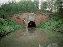 Bruce Tunnel - Eastern Portal (as seen in 1992) | |
| Overview | |
|---|---|
| Location | Wiltshire, England |
| Coordinates | 51°22′04″N 1°39′46″W / 51.3677°N 1.6627°WCoordinates: 51°22′04″N 1°39′46″W / 51.3677°N 1.6627°W |
| OS grid reference | SU23586323 |
| Status | Open |
| Waterway | Kennet and Avon Canal |
| Operation | |
| Constructed | 1806-1809 |
| Owner | Canal & River Trust |
| Technical | |
| Length | 502 yards (459 m) |
| Towpath | No |
The Bruce Tunnel is on the summit pound of the Kennet and Avon Canal between Wootton Top Lock and Crofton Locks in Wiltshire, England.
This is the only tunnel on the canal and it is 502 yards (459 m) long.[1] It is named after Thomas Brudenell-Bruce, 1st Earl of Ailesbury (1729–1814), the local landowner, who, when the canal was being built, would not allow a deep cutting through his land, and insisted on a tunnel instead.[2]
At the eastern end of the tunnel is a plaque commemorating its construction:
| The Kennet and Avon Canal Company Inscribe this TUNNEL with the Name of BRUCE In Testimony of the Gratitude for the uniform and effectual Support of The Right honourable THOMAS BRUCE EARL of AILESBURY and CHARLES LORD BRUCE his Son through the whole Progress of this great National Work by which a direct communication by Water was opened between the Cities of LONDON and BRISTOL ANNO DOMINI 1810 |
The tunnel has red brick portals, capped with Bath stone, each with a decorative plaque of Pennant stone. Construction was begun in 1806 and finished in 1809. It is lined with English bond brickwork and has a wide bore to cope with the 'Newbury Barges' used on this canal.[3]
There is no towpath through the tunnel, so walkers and cyclists must walk across the top of the hill. When canal boats were still pulled by horses, the boatmen had to haul boats through the tunnel by hand, pulling on chains that ran along the inside walls.
The tunnel is about 0.6 miles (1 km) northeast of Burbage village. To the north lies the Savernake Forest which is open to the public with footpaths, drives and picnic sites, hence the tunnel is also sometimes known as the Savernake Tunnel.
The main Paddington to Penzance 'Berks and Hants' railway line crosses the tunnel diagonally; both portals can be seen from the windows of passing trains with the canal running close to the railway at each end.
See also
References
| Wikimedia Commons has media related to Bruce Tunnel. |
- ↑ Allsop, Niall (1987). The Kennet & Avon Canal. Bath: Millstream Book. ISBN 0-948975-15-6.
- ↑ "History & Museum". Kennet and Avon Canal Trust. Retrieved 2010-11-21.
- ↑ "Bruce Tunnel". Kennet and Avon Canal. Retrieved 2006-09-22.