Brownstown Charter Township, Michigan
| Charter Township of Brownstown, Michigan | |
|---|---|
| Charter township | |
|
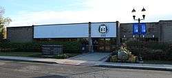
Township Offices | |
| Motto: "Where The Future Looks Brighter"[1] | |
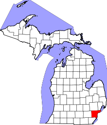
 Location in Wayne County and the state of Michigan | |
| Coordinates: 42°7′34″N 83°15′26″W / 42.12611°N 83.25722°WCoordinates: 42°7′34″N 83°15′26″W / 42.12611°N 83.25722°W | |
| Country | United States |
| State | Michigan |
| County | Wayne |
| Government | |
| • Supervisor | Andrew Linko |
| Area | |
| • Total | 30.5 sq mi (79 km2) |
| • Land | 22.5 sq mi (58.3 km2) |
| • Water | 8 sq mi (20.7 km2) |
| Elevation | 584 ft (178 m) |
| Population (2010) | |
| • Total | 30,627 |
| Time zone | EST (UTC-5) |
| • Summer (DST) | EDT (UTC-4) |
| ZIP codes | 48100-48199 |
| Area code(s) | 734 |
| FIPS code | 26-11220[2] |
| GNIS feature ID | 1625993[3] |
| Website | The Charter Township of Brownstown, Michigan |
Brownstown Charter Township is a charter township of Wayne County in the U.S. state of Michigan. The population was 30,627 at the 2010 census.
It is part of the collection of communities known as Downriver. Brownstown's three separate segments are due to the incorporation of the cities of Flat Rock, Rockwood, and Woodhaven in the early 1960s.[4]
History

The region now known as Brownstown was, like surrounding areas in Michigan, once a part of the French Province Quebec. The area eventually fell into hands of the British and finally came under American rule in the 18th century. The original 43-square-mile (110 km2) area of land south of Detroit was designated a township by the Michigan Territorial Commission on April 5, 1827, when Moses Roberts was elected its first supervisor. This made Brownstown one of Wayne County's nine original townships.[5]
Research from local historians have found that the township was named for Adam Brown, who was kidnapped by the Wyandot Indians. Brown was raised by the Wyandots, married a native woman and grew to become a tribal leader. As time passed, settlements spread out from the lakeshore to begin changing the swampy, sand-hill countryside into productive farm land. Established in 1893 Kurtzhals Farm is one of the largest remaining farms in the township.[5] [6]
Geography
According to the United States Census Bureau, the township has a total area of 30.5 square miles (79 km2), of which 22.5 square miles (58 km2) is land and 8.1 square miles (21 km2) (26.47%) is water. It is divided into three sections, two of which meet at a corner.
Demographics
As of the census[2] of 2000, there were 22,989 people, 8,322 households, and 6,249 families residing in the township. The population density was 1,024.0 per square mile (395.4/km²). There were 9,008 housing units at an average density of 401.3 per square mile (154.9/km²). The racial makeup of the township was 89.02% White, 3.82% African American, 0.53% Native American, 3.83% Asian, 0.86% from other races, and 1.95% from two or more races. Hispanic or Latino of any race were 3.58% of the population.
There were 8,322 households out of which 40.3% had children under the age of 18 living with them, 58.6% were married couples living together, 12.6% had a female householder with no husband present, and 24.9% were non-families. 19.8% of all households were made up of individuals and 4.3% had someone living alone who was 65 years of age or older. The average household size was 2.76 and the average family size was 3.18.
In the township the population was spread out with 28.7% under the age of 18, 9.4% from 18 to 24, 32.7% from 25 to 44, 23.4% from 45 to 64, and 5.8% who were 65 years of age or older. The median age was 33 years. For every 100 females there were 97.9 males. For every 100 females age 18 and over, there were 94.7 males.
The median income for a household in the township was $55,239, and the median income for a family was $65,544. Males had a median income of $50,246 versus $29,614 for females. The per capita income for the township was $22,523. About 5.7% of families and 6.9% of the population were below the poverty line, including 8.3% of those under age 18 and 7.4% of those age 65 or over.
As of 2010 the population of Brownstown Township was 30,627. The racial and ethnic makeup of the population was 79.0% Non-Hispanic white, 8.6% black or African-American, 0.4% Native American, 5.2% Asian, 0.1% Non-Hispanics of some other race, 2.1% reporting two or more races and 5.2% Hispanic or Latino.[7]
Economy
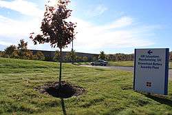
The township is also home to the Chevrolet Volt Battery Pack Assembly Plant. GM converted an empty warehouse on Sibley and King roads between I-75 and Allen Road into a temporary plant.[8]
Education
Most of Woodhaven-Brownstown School District. The district includes eight separate schools and students from both the City of Woodhaven and Brownstown Township may attend the district.[9] Woodhaven High School is the high school for the district.[10]
A portion of it is in the Gibraltar School District.[11][12]
A small neighborhood, south of Pennsylvania Road and west of Telegraph within Brownstown, attend the Taylor School District. These students are assigned to Eureka Heights Elementary School,[13] West Middle School,[14] and John F. Kennedy High School, all in Taylor.[15]
Residents in the northern section were once served by the Bacon Memorial Library in Wyandotte, but are now served by the Riverview Public Library in Riverview, meanwhile, residents of the southern section are served by the Trenton Veterans Memorial Library in Trenton.[16]
References
- ↑ "The Charter Township of Brownstown, Michigan". The Charter Township of Brownstown, Michigan. Retrieved August 24, 2012.
- 1 2 "American FactFinder". United States Census Bureau. Archived from the original on 2013-09-11. Retrieved 2008-01-31.
- ↑ U.S. Geological Survey Geographic Names Information System: Brownstown Charter Township, Michigan
- ↑ History of Woodhaven Archived July 5, 2007, at the Wayback Machine.
- 1 2 "History", Brownstown Township web site
- ↑ "Wyandotte Nation Adam Brown biography". Wyandotte Nation. Retrieved August 11, 2014.
Excerpted from the C. A. Buser files and the book, The Provisional Government of Nebraska Territory and The Journals of William Walker, Provisional Governor of Nebraska Territory – Edited by William E. Connelley
- ↑ 2010 census chart for Brownstown Archived May 20, 2011, at the Wayback Machine.
- ↑
- ↑ http://schools.nationalrelocation.com/district/2636485/
- ↑ "Woodhaven-Brownstown School District". Woodhaven-Brownstown School District. Retrieved August 24, 2012.
- ↑ "Gibraltar District Map" (Archive). Gibraltar School District. Retrieved on June 15, 2014.
- ↑ "Zoning Map" (Archive). Brownstown Township, Michigan. Retrieved on June 15, 2014.
- ↑ "Elementary School Boundary Map." Taylor School District. Retrieved on April 20, 2014.
- ↑ "Middle School Boundary Map." Taylor School District. Retrieved on April 20, 2014.
- ↑ "High School Boundary Map." Taylor School District. Retrieved on April 20, 2014.
- ↑ "District Map" (Archive). Brownstown Township. Retrieved on June 15, 2014.
External links

Municipalities and communities of Wayne County, Michigan, United States | ||
|---|---|---|
| Cities |
|  |
| Charter townships | ||
| General law townships | ||
| Unincorporated community | ||
| Footnotes | ‡This populated place also has portions in an adjacent county or counties | |
| Topics |  | |
|---|---|---|
| Detroit | ||
| Municipalities over 80,000 | ||
| Municipalities 40,000 to 80,000 | ||
| Cultural enclaves | ||
| Satellite cities | ||
| Counties in MSA | ||
| Counties in CSA | ||