Browns Field (New South Wales)
| Browns Field (New South Wales) New South Wales | |
|---|---|
 | |
 rainforest at Browns Field | |
 Browns Field (New South Wales) | |
| Coordinates | 33°44′2.8″S 151°06′30.45″E / 33.734111°S 151.1084583°ECoordinates: 33°44′2.8″S 151°06′30.45″E / 33.734111°S 151.1084583°E |
| Website | Browns Field (New South Wales) |
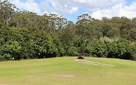
Browns Field is located in suburban Wahroonga, 17 km (11 mi) from the centre of Sydney, Australia. It contains a small sporting ground and a bushland reserve. A unique rainforest grows nearby, due to enriched soils from ancient volcanic activity.[1]
Geology
Browns Field is situated on a maar-diatreme. It was around 200 metres in diameter. The mafic soils are a typical dark colour. The diatreme occurred in the early Jurassic, around 200 million years ago. The volcanic explosion erupted through the local Sydney sandstone. Much of the rock formed by the diatreme is buried under soil cover, as well as landfill that helped create the sports oval at Browns Field. The soil is a mixture of organic material, and a soil horizon made up of weathered regolith particles. Rocky evidence of the diatreme is not obviously seen.[1][2]
History
The local indigenous Australian people, the Kuringgai occupied this area for thousands of years. The emancipated convict Thomas Hyndes settled the nearby area in 1822. In 1838, Governor Darling made a 259 hectare land grant to Hyndes. He worked the land with convict labour supplying timber to the colony of New South Wales. In 1854 the area was sold to John Brown, a merchant and timber getter. He also planted orchards nearby.[3] Locally known as 'Squire Brown', he owned of a square mile of land. At his peak, he employed one hundred pairs of pit-sawyers. These were used for various projects, including the supply of timber for the Pyrmont and Glebe Island Bridges.[4] The area currently used as a sporting field was once indigenous forest, and later, a rubbish tip.
Recreation
The oval is used for various activities such as football and cricket.[5] A bushwalking track starts near the field.[6]
Flora
Many rainforest plants unusual to the Sydney area are present. Such as golden sassafras,[7] jackwood, scrub turpentine, wild quince, giant maidenhair, fishbone water fern, strap water fern, and the sub tropical rainforest tree, the koda.[8] The paucity of fire, dark volcanic soils and high rainfall, contribute to rainforest vegetation. The average annual rainfall is 1,400 mm (55 in) at the nearby Kissing Point Road weather station.[9]
Fauna
Ring-tail possums, brushtail possums and grey-headed flying foxes are common. Many bird species live nearby, such as rainbow lorikeets, Australian king parrots, crimson rosellas, currawongs, koel and the tawny frogmouth. The powerful owl is known to nest in the reserve.[1]
Bush regeneration
Forest conservation work is in progress. The weeds trad and privet being particularly troublesome.[8]
References
- 1 2 3 Field Guide to the Bushland of the Lane Cove Valley - John Martyn ISBN 9780957839021 page 106
- ↑ Browns Field Diatreme.pdf - Ku-ring-gai Council
- ↑ FOX VALLEY ROAD WAHROONGA HERITAGE CONSERVATION AREA REVIEW SUMMARY REPORT John Oultram Heritage & Design Level 2, 386 New South Head Road, Double Bay, NSW 2028 retrieved September 27th, 2016
- ↑ Ku-ring-gai Historical Society - Wahroonga, retrieved September 29th, 2016
- ↑ Facilities at Browns Field
- ↑ Ku-ring-gai Council - Twin Creeks and Browns Field Track
- ↑ Australian Virtual Herbarium: record of Doryphora sassafras at Browns Field, retrieved September 29th, 2016
- 1 2 Ku-ring-gai Council - information sign
- ↑ http://www.bom.gov.au/ Bureau of Meteorology, Australian Government - Kissing Point Road Weather Station