Brooklyn, Michigan
| Brooklyn, Michigan | |
|---|---|
| Village | |
|
Main Street downtown area | |
| Motto: " A Place For All Seasons"[1] | |
 Location of Brooklyn within Jackson County, Michigan | |
| Coordinates: 42°6′21″N 84°14′56″W / 42.10583°N 84.24889°WCoordinates: 42°6′21″N 84°14′56″W / 42.10583°N 84.24889°W | |
| Country | United States |
| State | Michigan |
| County | Jackson |
| Area[2] | |
| • Total | 1.02 sq mi (2.64 km2) |
| • Land | 1.01 sq mi (2.62 km2) |
| • Water | 0.01 sq mi (0.03 km2) |
| Elevation | 991 ft (303 m) |
| Population (2010)[3] | |
| • Total | 1,206 |
| • Estimate (2012[4]) | 1,203 |
| • Density | 1,194.1/sq mi (461.0/km2) |
| Time zone | Eastern (EST) (UTC-5) |
| • Summer (DST) | EDT (UTC-4) |
| ZIP code | 49230 |
| Area code(s) | 517 |
| FIPS code | 26-11000[5] |
| GNIS feature ID | 2397467[6] |
| Website | Village of Brooklyn, Michigan |

Brooklyn (formerly Swainsville) is a village in Jackson County of the U.S. state of Michigan. The population was 1,206 at the 2010 census. It is located just off U.S. Highway 12 (formerly US 112) in Columbia Township.
Brooklyn is located in a portion of central lower Michigan known for its lush, rolling green landscapes in the Irish Hills area of Southeast Michigan which contains scenic lakes surrounding Hayes State Park and Cambridge Junction Historic State Park which adjoins the Michigan International Speedway. The area was primarily a summer vacation spot for residents of metropolitan Detroit who owned cottages near lakes in the area. With the nearby additions of Interstate 94 in the late 1950s and Michigan International Speedway in the late 1960s, Brooklyn established a year-round population. This city is also 14 miles (23 km) southeast of Jackson, 37 miles (60 km) southwest of Ann Arbor and 56 miles (90 km) southeast of Lansing.
History
The village was founded by Calvin Swain, who filed the first land claim on June 16, 1832 and named his settlement Swainsville. In a town meeting vote on August 5, 1836, the community elected to change the town's name to Brooklyn. The town is named after Brooklyn, New York.[7]
A sign marking Swain's historical discovery currently stands in the town square.
Street Art: In 2015 a small street art revolution happened along Monroe and water streets. Artists were brought in by local resident Josh Mitoska and several large scale wall murals were painted by Bonus Saves, THOR,PHYBR, Andrew Hall, And world famous female artist from Paris KASHINK-, as well as others. The art has brought in a large amount of outside visitors to the area as well as drawn some criticism from local residents with one resident citing "This is becoming a circus"
Geography
According to the United States Census Bureau, the village has a total area of 1.02 square miles (2.64 km2), of which 1.01 square miles (2.62 km2) is land and 0.01 square miles (0.03 km2) is water.[2]
Demographics
| Historical population | |||
|---|---|---|---|
| Census | Pop. | %± | |
| 1860 | 334 | — | |
| 1870 | 544 | 62.9% | |
| 1880 | 470 | −13.6% | |
| 1890 | 596 | 26.8% | |
| 1900 | 494 | −17.1% | |
| 1910 | 662 | 34.0% | |
| 1920 | 611 | −7.7% | |
| 1930 | 733 | 20.0% | |
| 1940 | 749 | 2.2% | |
| 1950 | 862 | 15.1% | |
| 1960 | 986 | 14.4% | |
| 1970 | 1,112 | 12.8% | |
| 1980 | 1,110 | −0.2% | |
| 1990 | 1,027 | −7.5% | |
| 2000 | 1,176 | 14.5% | |
| 2010 | 1,206 | 2.6% | |
| Est. 2015 | 1,198 | [8] | −0.7% |
2010 census
As of the census[3] of 2010, there were 1,206 people, 577 households, and 306 families residing in the village. The population density was 1,194.1 inhabitants per square mile (461.0/km2). There were 661 housing units at an average density of 654.5 per square mile (252.7/km2). The racial makeup of the village was 96.9% White, 0.2% African American, 0.7% Native American, 1.3% Asian, and 0.8% from two or more races. Hispanic or Latino of any race were 2.9% of the population.
There were 577 households of which 27.0% had children under the age of 18 living with them, 34.7% were married couples living together, 13.5% had a female householder with no husband present, 4.9% had a male householder with no wife present, and 47.0% were non-families. 41.6% of all households were made up of individuals and 22.6% had someone living alone who was 65 years of age or older. The average household size was 2.09 and the average family size was 2.86.
The median age in the village was 43.6 years. 22.7% of residents were under the age of 18; 7.7% were between the ages of 18 and 24; 21.8% were from 25 to 44; 24.9% were from 45 to 64; and 23% were 65 years of age or older. The gender makeup of the village was 43.4% male and 56.6% female.
2000 census
As of the census[5] of 2000, there were 1,176 people, 507 households, and 297 families residing in the village. The population density was 1,171.1 per square mile (454.1/km²). There were 534 housing units at an average density of 531.8 per square mile (206.2/km²). The racial makeup of the village was 97.96% White, 0.26% Native American, 0.51% Asian, 0.51% from other races, and 0.77% from two or more races. Hispanic or Latino of any race were 1.96% of the population.
There were 507 households out of which 27.8% had children under the age of 18 living with them, 41.8% were married couples living together, 12.4% had a female householder with no husband present, and 41.4% were non-families. 35.9% of all households were made up of individuals and 18.1% had someone living alone who was 65 years of age or older. The average household size was 2.22 and the average family size was 2.87.
In the village the population was spread out with 23.5% under the age of 18, 7.2% from 18 to 24, 27.8% from 25 to 44, 19.6% from 45 to 64, and 21.9% who were 65 years of age or older. The median age was 40 years. For every 100 females there were 81.8 males. For every 100 females age 18 and over, there were 74.1 males.
The median income for a household in the village was $31,964, and the median income for a family was $48,750. Males had a median income of $32,727 versus $22,083 for females. The per capita income for the village was $18,933. About 9.7% of families and 12.1% of the population were below the poverty line, including 25.1% of those under age 18 and 12.1% of those age 65 or over.
Notable person
- Vivian Kellogg, first baseman in the All-American Girls Professional Baseball League; lived in Brooklyn; the Vivian Kellogg Field was dedicated at the Columbia Little League complex.
References
- ↑ "Village of Brooklyn, Michigan". Village of Brooklyn, Michigan. Retrieved August 25, 2012.
- 1 2 "US Gazetteer files 2010". United States Census Bureau. Archived from the original on 2012-07-14. Retrieved 2012-11-25.
- 1 2 "American FactFinder". United States Census Bureau. Retrieved 2012-11-25.
- ↑ "Population Estimates". United States Census Bureau. Archived from the original on 2013-06-17. Retrieved 2013-06-03.
- 1 2 "American FactFinder". United States Census Bureau. Archived from the original on 2013-09-11. Retrieved 2008-01-31.
- ↑ U.S. Geological Survey Geographic Names Information System: Brooklyn, Michigan
- ↑ "Profile for Brooklyn, Michigan, MI". ePodunk. Retrieved August 24, 2012.
- ↑ "Annual Estimates of the Resident Population for Incorporated Places: April 1, 2010 to July 1, 2015". Retrieved July 2, 2016.
- ↑ "Census of Population and Housing". Census.gov. Archived from the original on May 11, 2015. Retrieved June 4, 2015.
External links
- Village of Brooklyn government site
- Brooklyn and Irish Hills Chamber of Commerce
- The Brooklyn Exponent newspaper
Municipalities and communities of Jackson County, Michigan, United States | ||
|---|---|---|
| City | 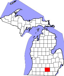 | |
| Villages | ||
| Charter townships | ||
| General law townships | ||
| CDPs | ||
| Other unincorporated communities | ||
| Footnotes | ‡This populated place also has portions in an adjacent county or counties | |