North Atlantic Igneous Province
The North Atlantic Igneous Province (NAIP) is a large igneous province in the North Atlantic, centered on Iceland. In the Paleogene, the province formed the Thulean Plateau, a large basaltic lava plain,[1] which extended over at least 1.3×10⁶ km2 in area and 6.6×10⁶ km3 in volume.[2] The plateau was broken up during the opening of the North Atlantic Ocean leaving remnants existing in Northern Ireland, bits of northwestern Scotland, the Faroe Islands, bits of northwestern Iceland, eastern Greenland and western Norway and many of the islands located in the north eastern portion of the North Atlantic Ocean.[3][4] The igneous province is the origin of the Giant's Causeway and Fingal's Cave. The province is also known as Brito-Arctic province (also known as the North Atlantic Tertiary Volcanic Province) and the portions of the province in the British Isles is also called the British Tertiary Volcanic Province or British Tertiary Igneous Province.
Formation
Isotopic dating indicates the most active magmatic phase of the NAIP was between ca. 60.5 and ca. 54.5 Ma (million years ago)[7] (mid-Paleocene to early Eocene) - further divided into Phase 1 (pre-break-up phase) dated to ca. 62-58 Ma and Phase 2 (syn-break-up phase) dated to ca. 56-54 Ma.[8]
Continuing research also indicates that continental plate movement (Eurasian, Greenland, and North American), that regional rifting events, and that seafloor spreading between Labrador and Greenland may have begun as early as ca. 95-80 Ma,[9] ca. 81 Ma,[10] and ca. 63-61 Ma[11][12] respectively (late Cretaceous to early Paleocene).
Studies have suggested that the modern day Iceland hotspot corresponds to the earlier 'North Atlantic mantle plume' that would have created the NAIP.[13] Through both geochemical observations and reconstructions of paleogeography, it is speculated that the present day Iceland hotspot originated as a mantle plume on the Alpha Ridge (Arctic Ocean) ca. 130-120 Ma,[14] migrated down Ellesmere Island, through Baffin Island, onto the west coast of Greenland, and finally arrived on the east coast of Greenland by ca. 60 Ma.[15]
Extensive outpourings of lava occurred, particularly in East Greenland,[16] which during the Paleogene was then adjacent to Britain. Little is known of the geodynamics of the opening of the North Atlantic between Greenland and Europe.[17]
As the earth's crust was stretched above the mantle hotspot under stress from plate rifting,[18] fissures opened up along a line from Ireland to the Hebrides and plutonic complexes were formed.[19] Hot magma over 1000 °C surfaced as multiple, successive and extensive lava flows covered over the original landscape, burning forests, filling river valleys, burying hills, to eventually form the Thulean Plateau, which contained various volcanic landforms such as lava fields and volcanoes.[5] There was more than one period of volcanic activity during the NAIP, in between which sea levels rose and fell and erosion took place.[20]
Volcanic activity would have started with volcaniclastic accumulations, like volcanic ash, quickly followed by vast outpourings of highly fluid basaltic lava during successive eruptions through multiple volcanic vents or in linear fissures. As mafic low viscosity lava reached the surface it rapidly cooled and solidified, successive flows built up layer upon layer, each time filling and covering existing landscapes. Hyaloclastites and pillow lavas were formed when the lava flowed into lakes, rivers and seas. Magma that did not make it to the surface as flows froze in conduits as dikes and volcanic plugs and large amounts spread laterally to form sills. Dike swarms extended across the British Isles throughout the Cenozoic. Individual central complexes developed with arcuate intrusions (cone sheets, ring dikes and stocks), the intrusions of one centre cut through earlier centres recording magmatic activity with time. During intermittent periods of erosion and change in sea levels, heated waters circulated through the flows altering the basalts and deposited distinctive suites of zeolite minerals.[6]
Activity of the NAIP 55 million years ago may have caused the Paleocene–Eocene Thermal Maximum, where a large amount of carbon was released into the atmosphere and the Earth substantially warmed. One hypothesis is that the uplift caused by the NAIP hotspot caused methane clathrates to dissociate and dump 2000 gigatons of carbon into the atmosphere.[21]
Igneous landforms

_-_geograph.org.uk_-_817036.jpg)
The NAIP is made up of both onshore and offshore basalt floods, sills, dykes, and plateaus. Dependent upon various regional locations, the NAIP is made up of MORB (Mid Ocean Ridge Basalt), alkali basalt,[22][23] tholeiitic basalt, and picrite basalt.[24]
Basaltic volcanic rocks up to 2.5 kilometres (1.6 mi) thick cover 65,000 square kilometres (25,000 sq mi) in east Greenland. Numerous intrusions related to hot-spot magmatism are exposed in the coastal region of east Greenland. The intrusions show a wide range of compositions. The Skaergaard intrusion (Early Cenozoic or about 55 million year age) is a layered gabbro (mafic) intrusion that has mineralized rock units enriched in palladium and gold. In contrast, the Werner Bjerge complex is made up of potassium- and sodium-rich (alkaline) granitic rock, containing molybdenum.[25]
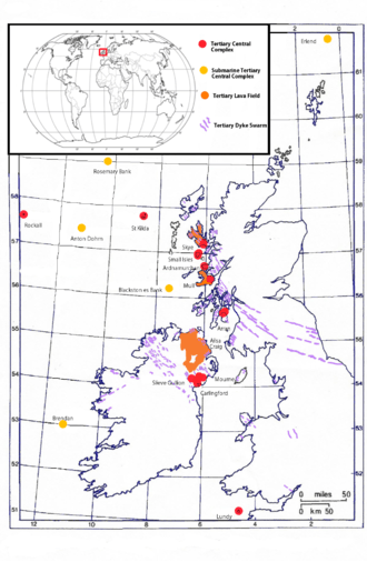
Locations of submarine central complexes within the NAIP include[19]
- Anton Dohrn Seamount
- Rosemary Bank
- Blackstones Bank
- Brendan
- Erlend
Within Britain
The British portion of the NAIP, particularly West Scotland, provides relatively easy access, compared to the largely inaccessible basalt fields of West Greenland, to deeply eroded relics of the central volcanic complexes.
Locations of major intrusion complexes within the British part of the NAIP include:
Other notable locations with NAIP landforms within Britain:
- Giant's Causeway – Polygonal basalt columns, which seen from above are large hexagonal pavements[46]
- Canna and Sanday – Basalt lava field with great thicknesses of boulder conglomerate, examples of periods of erosion by fast flowing rivers in between the lava flows.[47]
- Rathlin Island[48] – Paleogene and Neogene lava flows
- Fingal's Cave on the Isle of Staffa – Polygonal basalt columns eroded to form a cave[49]
- Ailsa Craig[44] – Volcanic plug
- Cleveland Dyke, North Yorkshire – Dyke swarm related to the Mull intrusive complex[50]
- The dike complexes of the NAIP contain many examples of dolerite dike swarms found throughout the British Isles.
History of geological studies
The intensity of scientific investigation within the NAIP has made it one of the most historically important and deeply studied igneous provinces in the world. Basalt petrology was born in the Scottish Hebrides in 1903 led by the eminent British Geologist Sir Archibald Geikie. From the outset Geikie studied the geology of Skye and other Western Isles taking a keen interest in volcanic geology and in 1871 he presented the Geological Society of London with an outline of the 'Tertiary Volcanic History of Britain'.[51] Following Geikie many have tried, and continue to study and understand the NAIP, and in doing so have advanced knowledge in geology, mineralogy and in more recent decades geochemistry and geophysics.[5]
See also
- Igneous rock
- Geologic province
- Mantle plume
- Hotspot
- Oceanic plateau
- Continental flood basalt
- Large igneous province
- Dike swarm
References
- ↑ Brittle tectonism in relation to the Palaeogene evolution of the Thulean/NE Atlantic domain: a study in Ulster Retrieved on 2007-11-10
- ↑ Eldholm, Olav; Kjersti Grue (10 February 1994). "North Atlantic volcanic margins: Dimensions and production rates". Journal of Geophysical Research: Solid Earth. 99 (B2): 2955–2968. Bibcode:1994JGR....99.2955E. doi:10.1029/93JB02879.
Quantitative calculations of NAVP dimensions, considered minimum estimates, reveal an areal extent of 1.3{{e|6}} km2 and a volume of flood basalts of 1.8×10⁶ km3, yielding a mean eruption rate of 0.6 km3/yr or 2.4 km3/yr if two-thirds of the basalts were emplaced within 0.5 m.y. The total crustal volume is 6.6×10⁶ km3, resulting in a mean crustal accretion rate of 2.2 km3/yr. Thus NAVP ranks among the world's larger igneous provinces if the volcanic margins are considered.
- ↑ D.W. Jolley; B.R. Bell, eds. (2002). The North Atlantic igneous province stratigraphy, tectonic, volcanic, and magmatic processes. London: Geological Society. ISBN 1-86239-108-4.
- ↑ Courtillot, Vincent E; Renne, Paul R (January 2003). "On the ages of flood basalt events" (PDF). Comptes Rendus Geoscience. 335 (1): 113–140. Bibcode:2003CRGeo.335..113C. doi:10.1016/S1631-0713(03)00006-3.
From file page 7 onward: Brito-Arctic Province section (section also discusses age, pulses of activity, and volume)
- 1 2 3 Emeleus, C.H.; Gyopari, M.C. (1992). British Tertiary Volcanic Province. Geological Conservation Review. London: Chapman & Hall on behalf of Joint Nature Conservation Committee.
- 1 2 Mussett, A. E.; Dagley, P.; Skelhorn, R. R. (1 January 1988). "Time and duration of activity in the British Tertiary Igneous Province". Geological Society, London, Special Publications. 39 (1): 337–348. Bibcode:1988GSLSP..39..337M. doi:10.1144/GSL.SP.1988.039.01.29.
- ↑ Jolley, D. W.; Bell, B. R. (1 January 2002). "The evolution of the North Atlantic Igneous Province and the opening of the NE Atlantic rift". Geological Society, London, Special Publications. 197 (1): 1–13. Bibcode:2002GSLSP.197....1J. doi:10.1144/GSL.SP.2002.197.01.01.
40Ar/39Ar and Pb-U isotopic age data show that the main period of continental flood basalt volcanism in the NAIP extended from ~60.5 Ma through to ~54.5 Ma.
- ↑ Rousse, S.; M. Ganerød; M.A. Smethurst; T.H. Torsvik; T. Prestvik (2007). "The British Tertiary Volcanics: Origin, History and New Paleogeographic Constraints for the North Atlantic" (PDF). Geophysical Research Abstracts. 9.
The NAIP formed during two major magmatic phases: a pre-break-up phase (62-58 Ma) and a syn-break-up phase (56-54 Ma) contemporaneous with the onset of North Atlantic sea floor spreading.
- ↑ Torsvik, T.H.; B. Steinberger; C. Gaina (2007). "North Atlantic Plate Motions and Plumes" (PDF). Geophysical Research Abstracts. 9.
Fixed hotspot frames show uniform NE movement of the coupled North American, Greenland, and Eurasian plates from ~95 to 80 Ma.
- ↑ Faleide, Jan Inge; Tsikalas, F.; Breivik, A. J.; Mjelde, R.; et al. (2008). "Structure and evolution of the continental margin off Norway and the Barents Sea" (PDF). Episodes. 31 (1): 82.
Breakup in the NE Atlantic was preceded by prominent Late Cretaceous-Paleocene rifting. At the onset of this rifting, the area between NW Europe and Greenland was an epicontinental sea covering a region in which the crust had been extensively weakened by previous rift episodes. Ren et al. (2003) suggested onset of rifting at about 81 Ma
- ↑ Larsen, Lotte Melchior; Rex, D. C.; Watt, W. S.; Guise, P. G. (1999). "40Ar/39Ar Dating of Alkali Basaltic Dykes along the Southwest Coast of Greenland: Cretaceous and Tertiary Igneous Activity along the Eastern Margin of the Labrador Sea" (PDF). Geology of Greenland Survey Bulletin (184): 19–29.
The start of normal velocity ocean floor spreading in the Labrador Sea took place in the Paleocene, around geomagnetic chrons C27-C28 (61-63 Ma) and was accompanied by a burst in volcanic activity, where large amounts of tholeiitic picrites and basalts were erupted onto the continental margins of West Greenland and Labrador
- ↑ Chalmers, J. A.; Pulvertaft, T.C.R. (1 January 2001). "Development of the continental margins of the Labrador Sea: a review". Geological Society, London, Special Publications. 187 (1): 77–105. Bibcode:2001GSLSP.187...77C. doi:10.1144/GSL.SP.2001.187.01.05.
The Labrador Sea is a small oceanic basin that developed when the North American and Greenland plates separated. An initial period of stretching in Early Cretaceous time formed sedimentary basins now preserved under the continental shelves and around the margins of the oceanic crust. The basins subsided thermally during Late Cretaceous time and a second episode of tectonism took place during latest Cretaceous and early Paleocene time, before the onset of sea-floor spreading in mid-Paleocene time.
- ↑ Lundin, Erik R.; Anthony G. Doré (2005). "Fixity of the Iceland "hotspot" on the Mid-Atlantic Ridge: Observational evidence, mechanisms, and implications for Atlantic volcanic margins". Geological Society of America Special Papers. 388: 627–651. doi:10.1130/0-8137-2388-4.627. ISBN 0-8137-2388-4.
- ↑ Saunders, A.D.; S. Drachev; M.K. Reichow (2005). "Tracking the Iceland Plume across the Arctic Ocean" (PDF). Geophysical Research Abstracts. 7.
It is widely assumed that Iceland sits above a mantle plume or hotspot. Plate reconstructions place the plume beneath what is now northeastern Canada at about 80 Ma. This correlates with an episode of basaltic volcanism in the Queen Elizabeth Islands, dated at around 90 Ma. The aseismic Alpha Ridge is bathymetrically linked to northern Ellesmere Island, and extends northwards beneath the Arctic Ocean.
- ↑ Tegner, C; Duncan, R; Bernstein, S; Brooks, C; Bird, D; Storey, M (15 March 1998). "40Ar/39Ar geochronology of Tertiary mafic intrusions along the East Greenland rifted margin: Relation to flood basalts and the Iceland hotspot track". Earth and Planetary Science Letters. 156 (1–2): 75–88. Bibcode:1998E&PSL.156...75T. doi:10.1016/S0012-821X(97)00206-9.
The East Greenland Tertiary Igneous Province includes the largest exposed continental flood basalt sequence within the North Atlantic borderlands. Plate-kinematic models indicate the axis of the ancestral Iceland mantle plume was located under Central Greenland at ~60 Ma and subsequently crossed the East Greenland rifted continental margin.
- ↑ Riisager, Janna; Riisager, Peter; Pedersen, Asger Ken (September 2003). "Paleomagnetism of large igneous provinces: case-study from West Greenland, North Atlantic igneous province". Earth and Planetary Science Letters. 214 (3–4): 409–425. Bibcode:2003E&PSL.214..409R. doi:10.1016/S0012-821X(03)00367-4.
- ↑ Geoffroy, Laurent; Bergerat, Francoise; Angelier, Jacques (September 1996). "Brittle tectonism in relation to the Palaeogene evolution of the Thulean/NE Atlantic domain: a study in Ulster". Geological Journal. 31 (3): 259–269. doi:10.1002/(SICI)1099-1034(199609)31:3<259::AID-GJ711>3.0.CO;2-8.
- ↑ Thompson, R. N.; Gibson, S. A. (1 December 1991). "Subcontinental mantle plumes, hotspots and pre-existing thinspots". Journal of the Geological Society. 148 (6): 973–977. doi:10.1144/gsjgs.148.6.0973.
- 1 2 Hitchen, K.; Ritchie, J. D. (1 May 1993). "New K–Ar ages, and a provisional chronology, for the offshore part of the British Tertiary Igneous Province". Scottish Journal of Geology. 29 (1): 73–85. doi:10.1144/sjg29010073.
- ↑ Williamson, I. T.; Bell, B. R. (3 November 2011). "The Palaeocene lava field of west-central Skye, Scotland: Stratigraphy, palaeogeography and structure". Transactions of the Royal Society of Edinburgh: Earth Sciences. 85 (1): 39–75. doi:10.1017/S0263593300006301.
- ↑ Maclennan, John; Jones, Stephen M. (2006). "Regional uplift, gas hydrate dissociation and the origins of the Paleocene–Eocene Thermal Maximum". Earth and Planetary Science Letters. 245 (1): 65–80. doi:10.1016/j.epsl.2006.01.069.
- ↑ Tarney, J.; Wood, D. A.; Saunders, A. D.; Cann, J. R.; Varet, J. (24 July 1980). "Nature of Mantle Heterogeneity in the North Atlantic: Evidence from Deep Sea Drilling". Philosophical Transactions of the Royal Society A: Mathematical, Physical and Engineering Sciences. 297 (1431): 179–202. Bibcode:1980RSPTA.297..179T. doi:10.1098/rsta.1980.0209.
Studies of dredged and drilled samples from the North Atlantic ocean have revealed that basalts with a wide range of major and trace element compositions have been generated at the Mid-Atlantic Ridge. Drilling along mantle flow lines transverse to the ridge has shown that different segments of the MAR have produced basalts with a distinct compositional range for tens of millions of years.
- ↑ Heister, L. E.; O'Day, P. A.; Brooks, C. K.; Neuhoff, P. S.; Bird, D. K. (1 March 2001). "Pyroclastic deposits within the East Greenland Tertiary flood basalts". Journal of the Geological Society. 158 (2): 269–284. doi:10.1144/jgs.158.2.269.
Stratigraphic, geochemical and mineralogical characterization of pyroclastic deposits on the Gronau West Nunatak of East Greenland indicates that both alkaline and basaltic tephras occurred during the eruption of flood basalts associated with the opening of the North Atlantic ocean in the early Tertiary.
- ↑ Brooks, C. K.; Nielsen, T. F. D.; Petersen, T. S. (1976). "The Blosseville Coast basalts of East Greenland: Their occurrence, composition and temporal variations". Contributions to Mineralogy and Petrology. 58 (3): 279–292. Bibcode:1976CoMP...58..279B. doi:10.1007/BF00402356.
Major and trace element compositions are presented for basalts from the area between Kangerdlugssuaq and Scoresby Sound, East Greenland. The bulk of these lavas have a very uniform composition and are tholeiites... The only significant variation is minor and represents a change to a more evolved type to the south, a variation which may be similar to that observed in Postglacial Icelandic lavas. The earliest lavas are of a picritic type…
- ↑
 This article incorporates public domain material from the United States Geological Survey document: Nokleberg, W.J.; Baweic, W.J.; Doebrich, J.L.; Lipin, B.R.; et al. (2005). "Geology and Nonfuel Mineral Deposits of Greenland, Europe, Russia, and Northern Central Asia" (PDF). USGS. Open File Report 2005–1294D.
 - ↑ Smith, Sandy; Clive Roberts (1997). "The Geology of Lundy". In Irving, RA; Schofield, AJ; Webster, CJ. Island Studies (PDF). Bideford: Lundy Field Society. Retrieved 7 November 2013.
- ↑ Thorpe, R. S.; Tindle, A. G.; Gledhill, A. (1 December 1990). "The Petrology and Origin of the Tertiary Lundy Granite (Bristol Channel, UK)". Journal of Petrology. 31 (6): 1379–1406. doi:10.1093/petrology/31.6.1379.
- ↑ "Carlingford Volcanic Centre". Geological Survey of Ireland. Retrieved 7 November 2013.
- ↑ Le Bas, M. J. (1966–1967). "On the Origin of the Tertiary Granophyres of the Carlingford Complex, Ireland". Proceedings of the Royal Irish Academy. Section B: Biological, Geological, and Chemical Science. 65: 325–338. JSTOR 20518864.
- ↑ Devlin, Pat. "Mourne Mountains". The Devlin Family On-Line. Retrieved 7 November 2013.
- ↑ Hood, D; Meighan, I.; Gibson, D.; Mccormack, A. (July 1981). "The Tertiary Granites of the Eastern And Western Mourne Centers, Northern-Ireland". Journal of the Geological Society. 138: 497–497.
- ↑ Porter, E M (3 May 2003). "Slieve Gullion Ring – Overview". Geological Sites in Northern Ireland – Earth Science Conservation Review. National Museums Northern Ireland. Retrieved 7 November 2013.
- ↑ Gamble, J. A.; Meighan, I. G.; Mccormick, A. G. (1 February 1992). "The petrogenesis of Tertiary microgranites and granophyres from the Slieve Gullion Central Complex, NE Ireland". Journal of the Geological Society. 149 (1): 93–106. doi:10.1144/gsjgs.149.1.0093.
- ↑ "Geology Section". Isle of Arran Heritage Museum. Retrieved 7 November 2013.
- ↑ Meade, F. C.; Chew, D. M.; Troll, V. R.; Ellam, R. M.; Page, L. M. (22 December 2009). "Magma Ascent along a Major Terrane Boundary: Crustal Contamination and Magma Mixing at the Drumadoon Intrusive Complex, Isle of Arran, Scotland". Journal of Petrology. 50 (12): 2345–2374. doi:10.1093/petrology/egp081.
- ↑ Jones, Rosalind. "The Geology of Mull". Mull and Iona Chamber of Commerce – Holiday information site. Mull and Iona Chamber of Commerce. Retrieved 19 December 2013.
- ↑ Dagley, P.; Mussett, A.; Skelhorn, R. (1983). "Polarity Stratigraphy And Duration of the Mull Tertiary Igneous Intrusive Complex". Geophysical Journal of the Royal Astronomical Society. 73 (1): 308–308.
- ↑ "Tertiary Volcanic Complex – Shepherd's Hut, Kilchoan, Ardnamurchan". The Lochan Shepherd's Hut. Retrieved 7 November 2013.
- ↑ Geldmacher, Jörg; Haase, Karsten M.; Devey, Colin W.; Garbe-Schönberg, C. Dieter (27 April 1998). "The petrogenesis of Tertiary cone-sheets in Ardnamurchan, NW Scotland: petrological and geochemical constraints on crustal contamination and partial melting". Contributions to Mineralogy and Petrology. 131 (2–3): 196–209. Bibcode:1998CoMP..131..196G. doi:10.1007/s004100050388.
- ↑ Holness, M.B.; Isherwood, C.E. (1 January 2003). "The aureole of the Rum Tertiary Igneous Complex, Scotland". Journal of the Geological Society. 160 (1): 15–27. doi:10.1144/0016-764901-098.
- ↑ Dagley, P.; Mussett, A. E. (April 1986). "Palaeomagnetism and radiometric dating of the British Tertiary Igneous Province: Muck and Eigg". Geophysical Journal International. 85 (1): 221–242. Bibcode:1986GeoJ...85..217B. doi:10.1111/j.1365-246X.1986.tb05180.x.
- ↑ "Skye – Cuillin Hills". scottishgeology.com. Retrieved 7 November 2013.
- ↑ Fowler, S. J.; Bohrson, W.; Spera, F. (19 August 2004). "Magmatic Evolution of the Skye Igneous Centre, Western Scotland: Modelling of Assimilation, Recharge and Fractional Crystallization". Journal of Petrology. 45 (12): 2481–2505. doi:10.1093/petrology/egh074.
- 1 2 Meighan, I. G.; Fallick, A. E.; McCormick, A. G. (3 November 2011). "Anorogenic granite magma genesis: new isotopic data for the southern sector of the British Tertiary Igneous Province". Transactions of the Royal Society of Edinburgh: Earth Sciences. 83 (1–2): 227–233. doi:10.1017/S0263593300007914.
- ↑ Bull, J. M.; Masson, D. G. (1 August 1996). "The southern margin of the Rockall Plateau: stratigraphy, Tertiary volcanism and plate tectonic evolution". Journal of the Geological Society. 153 (4): 601–612. doi:10.1144/gsjgs.153.4.0601.
- ↑ "Geological Succession". Giant's Causeway. Retrieved 7 November 2013.
- ↑ "Canna and Sanday". Rum and the Small Islands Online Publication. Scottish Natural Heritage. Retrieved 7 November 2013.
- ↑ Dawson, J. (April 1951). "The Brockley Dolerite Plug and the Church Bay Volcanic Vent, Rathlin Island, Co. Antrim". The Irish Naturalists' Journal. 10 (16): 156–162. JSTOR 25533950.
- ↑ Williamson, I. T.; Bell, B. R. (24 May 2012). "The Staffa Lava Formation: graben-related volcanism, associated sedimentation and landscape character during the early development of the Palaeogene Mull Lava Field, NW Scotland". Scottish Journal of Geology. 48 (1): 1–46. doi:10.1144/0036-9276/01-439.
- ↑ MacDonald, R.; Wilson, L.; Thorpe, R. S.; Martin, A. (1 June 1988). "Emplacement of the Cleveland Dyke: Evidence from Geochemistry, Mineralogy, and Physical Modelling". Journal of Petrology. 29 (3): 559–583. doi:10.1093/petrology/29.3.559.
- ↑ Geikie, Archibald (1897). The ancient volcanoes of Great Britain. London: Macmillan.
External links
- Map of NAIP - from Kent, R. W.; J. Godfrey Fitton (1 July 2000). "Mantle Sources and Melting Dynamics in the British Palaeogene Igneous Province". Journal of Petrology. 41 (7): 1023–1040. doi:10.1093/petrology/41.7.1023.
- Paleogeographic Map of NAIP - from Ellam, R. M.; F. M. Stuart (1 July 2000). "The Sub-lithospheric Source of North Atlantic Basalts: Evidence for, and Significance of, a Common End-member". Journal of Petrology. 41 (7): 919–932. doi:10.1093/petrology/41.7.919.
- Mantle Plumes - Iceland Hotspot page
- Large Igneous Province Commission - home page