Britford
| Britford | |
 St Peter's parish church |
|
 Britford |
|
| Population | 592 (2011 Census)[1] |
|---|---|
| OS grid reference | SU160282 |
| Civil parish | Britford |
| Unitary authority | Wiltshire |
| Ceremonial county | Wiltshire |
| Region | South West |
| Country | England |
| Sovereign state | United Kingdom |
| Post town | Salisbury |
| Postcode district | SP5 |
| Dialling code | 01722 |
| Police | Wiltshire |
| Fire | Dorset and Wiltshire |
| Ambulance | South Western |
| EU Parliament | South West England |
| UK Parliament | Salisbury |
| Website | Parish Council |
Coordinates: 51°03′11″N 1°46′23″W / 51.053°N 1.773°W
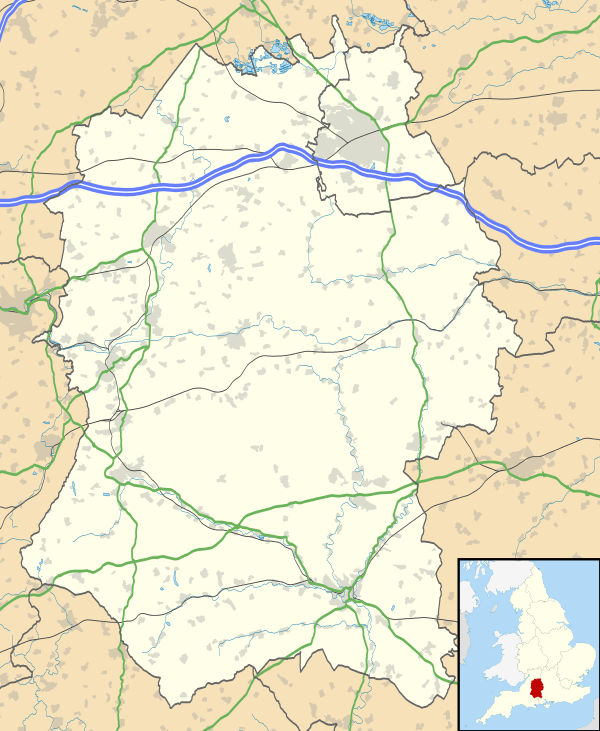
Britford is a village and civil parish beside the River Avon about 1.5 miles (2.4 km) southeast of Salisbury in Wiltshire, England. The village is just off the A338 road. The 2011 Census recorded a parish population of 592.[1]
The place-name 'Britford' is first attested in a Saxon charter of circa 670, where it appears as Brytfordingea. It appears as Bretford and Bredford in the Domesday Book of 1086, and as Brideford in the Curia Regis Rolls of 1203. The name means 'brides' ford', and has the same etymology as Bridford in Devon.[2]
Archaeology
Little Woodbury, 0.5 miles (800 m) southwest of the village, is the site of an Iron Age settlement.[3] Excavations in 1938–39 revealed the sites of granaries, storage pits and a circular house nearly 50 feet (15 m) in diameter.[4]
Great Woodbury, 1 mile (1.6 km) from the village, is the remains of an Iron Age hill fort.
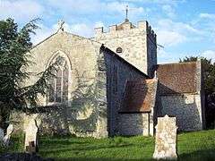
Parish church
The nave of the Church of England parish church of Saint Peter is Saxon, built probably in the 9th century.[5][6] On each side of the nave there is a round-headed Saxon arch into a porticus (small space for a side-chapel).[5] The arch to the south porticus is plain, but that to the north porticus is supported by decorated stone slabs.[5] The carving on one slab seems to be developed from the style of decoration of the Bewcastle and Ruthwell crosses at the beginning of the 8th century; the style of the other seems to be 9th century.[5]
In the 14th century the north and south transepts were added, making the church the cruciform building it is today.[5] Each transept is next to the Saxon porticus on its corresponding side and includes the east wall of that porticus. The arches where the transepts meet the nave are Decorated Gothic, as is the east window of the chancel.[5] A 15th-century tomb chest monument in the church is supposed to be that of Henry Stafford, 2nd Duke of Buckingham who was executed in Salisbury in 1483.[3] Also 15th-century is a small, iron-bound wooden chest in the north transept.[3]
The finely-carved pulpit is late 17th century.[3]
The west wall of the nave was rebuilt in 1764.[6] Over the crossing is a central tower, which was rebuilt in 1764[6] or 1767.[3] John Robartes, 1st Earl of Radnor had a mausoleum added to the northwest corner of the north transept in 1764[6] or 1777.[3] The building was restored in 1873 to the designs of George Edmund Street, who had the Radnor mausoleum Gothicised or rebuilt.[6][3] The west window of the nave has stained glass made by Ward and Hughes of London in 1882.[6] St Peter's is a Grade I listed building.[6]
In the second quarter of the 13th century Britford had an anchoress called Joan.[7] In 1215 King John granted her an income of one penny per day.[7] She received royal gifts of oaks in 1226, 1231 and 1245.[7] In 1237 the sheriff of Salisbury was ordered to ensure that the courtyard around her house was securely enclosed with a wall.[7]
St Peter's has a ring of six bells. Five including the tenor bell were cast in 1765 by Robert Wells I[8] of Aldbourne.[9] The treble bell was cast in 1899 by Thomas Blackbourn[8] of Salisbury.[9]
St Peter's is now one of 13 parishes in the Benefice of Chalke Valley.[10]
Secular history
Rectory Farmhouse,[11] northwest of St Peter's, is a 17th-century house with a symmetrical front of three bays.[3] At the front the two ground-floor windows have four lights and a transom;[3] the first floor windows have ovolo-moulded mullions.[11] It is a Grade II* listed building.[11]
Moat House, southwest of St Peter's, is a 17th-century house surrounded by a moat.[12] The house was remodelled in 1766 and again in the 19th century, so that externally it looks early 19th century Georgian.[3] It is now divided into two houses.[12]
There are Georgian cottages on the main A338 road, built for the Longford Castle estate.[3]
In 1664 an Act of Parliament authorised the conversion of the River Avon into a navigation between Salisbury and the English Channel at Christchurch.[13] Canalised channels were dug to straighten sections of the river, including one about a 1 mile (1.6 km) long through Britford parish. The river had ceased to be navigable by 1737[13] but bridges over it and remains of locks still survive around Britford.[3]
Local government
The civil parish elects a parish council. It is in the area of Wiltshire Council unitary authority, which performs all significant local government functions.
The ancient parish of Britford included the tithing of East Harnham,[14] which became a separate ecclesiastical parish in 1855 after a church was built there in the previous year. East Harnham continued as part of Britford civil parish until 1896, when it became a separate parish; in 1904 it joined the borough of Salisbury and is now part of Harnham suburb.[15]
Amenities

Britford has a Church of England primary school, built in 1959 to replace a National School which opened in 1853.[16] On 1 April 2010 it merged with the primary school in Odstock to form Longford C of E Primary School,[17] named after the Longford estate. Both sets of buildings remain in use: the Britford site teaches Key Stage 1 and the Odstock site teaches Key Stage 2.
Salisbury District Hospital is in the parish about 1 mile (1.6 km) southwest of the village.
A Park and Ride bus service for journeys to Salisbury operates from a site on the A338 near the village.[18]
References
- 1 2 "Area: Britford (Parish); Key Figures for 2011 Census: Key Statistics". Neighbourhood Statistics. Office for National Statistics. Retrieved 22 November 2013.
- ↑ Eilert Ekwall, The Concise Oxford Dictionary of English Place-names, p.66.
- 1 2 3 4 5 6 7 8 9 10 11 12 Pevsner & Cherry 1975, p. 143.
- ↑ Pevsner & Cherry 1975, p. 144.
- 1 2 3 4 5 6 Pevsner & Cherry 1975, p. 142.
- 1 2 3 4 5 6 7 Historic England. "Church of St Peter and attached Radnor Mausoleum (1023791)". National Heritage List for England. Retrieved 9 November 2015.
- 1 2 3 4 Pugh & Crittall 1956, pp. 362–364.
- 1 2 Dawson, George (21 December 2006). "Britford S Peter". Dove's Guide for Church Bell Ringers. Central Council of Church Bell Ringers. Retrieved 3 September 2013.
- 1 2 Dovemaster (31 October 2012). "Bell Founders". Dove's Guide for Church Bell Ringers. Central Council of Church Bell Ringers. Retrieved 3 September 2013.
- ↑ Archbishops' Council (2010). "Benefice of Chalke Valley (Team Ministry)". A Church Near You. Church of England. Retrieved 3 September 2013.
- 1 2 3 Historic England. "Rectory Farmhouse (1023790)". National Heritage List for England. Retrieved 9 November 2015.
- 1 2 Historic England. "Moat House (1023794)". National Heritage List for England. Retrieved 9 November 2015.
- 1 2 Cross 1970
- ↑ "Victoria County History – Wiltshire – Vol 4 pp315-361 – Table of population, 1801–1951". British History Online. University of London. Retrieved 9 November 2015.
- ↑ "Britford". Wiltshire Community History. Wiltshire Council. Retrieved 9 November 2015.
- ↑ "Longford C of E (VC) Primary School, Britford". Wiltshire Community History. Wiltshire Council. Retrieved 9 November 2015.
- ↑ "About Longford School". Longford C of E Primary School. 2013. Retrieved 3 September 2013.
- ↑ "Salisbury Park & Ride". Wiltshire Council. Retrieved 9 November 2015.
Sources
- Cross, Donald Alfred Edgar (1970). "The Salisbury Avon Navigation". Industrial Archaeology. David & Charles. VII (2): 121–135.
- Pevsner, Nikolaus; Cherry, Bridget (revision) (1975) [1963]. Wiltshire. The Buildings of England (revised ed.). Harmondsworth: Penguin Books. pp. 142–144. ISBN 0-14-0710-26-4.
- Pugh, R.B.; Crittall, Elizabeth, eds. (1956). A History of the County of Wiltshire. Victoria County History. 3. pp. 362–364.
External links
| Wikimedia Commons has media related to Britford. |