Bright Angel Shale
| Bright Angel Shale Stratigraphic range: Middle Cambrian[1][2] | |
|---|---|
|
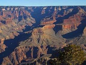
Muav Limestone-(dk or lt gray, brown, or orange-red subcliff at base of Redwall Limestone cliff) and Bright Angel Shale (greenish slope-former), resting on Tapeats Sandstone (short, dp brown vertical cliff) (Tapeats forms the "Tonto Platform"), inner canyon, Granite Gorge. (The 3 units–Muav, Bright Angel, and Tapeats, are easily seen below the red-stained Redwall Limestone (550 ft thick)) | |
| Type | Geological formation |
| Unit of | Tonto Group |
| Underlies | Muav Limestone |
| Overlies | Tapeats Sandstone |
| Thickness | 500 feet (150 m) at its maximum |
| Lithology | |
| Primary | micaceous siltstone and shale |
| Other | sandstone and glauconitic sandstone |
| Location | |
| Region | northern Arizona, southeast California, southern Nevada, and southcentral Utah |
| Country | United States of America |
| Type section | |
| Named for | Bright Angel Canyon, Bright Angel quadrangle, Coconino Co., Arizona[3] |
| Named by | Noble (1914)[3] |
The Cambrian Bright Angel Shale is the middle member of the 3-member Tonto Group. It is about 500 feet (152 m) thick at its maximum.[4] It is a nonresistant slope-forming unit. The Bright Angel Shale consists of green and purple-red, siltstone and shale which is interbedded with red-brown to brown sandstone that is similar in lithology to the underlying Tapeats.[5] The Bright Angel Shale underlies and interfingers with Muav Limestone. The Bright Angel Shale is located in the lower elevations of the Grand Canyon, Arizona.[6]
Geologic sequence
The units of the Tonto Group:[4]
- (1)-Temple Butte Limestone, Devonian-(409-363 Ma), channel deposits upon Muav Limestone
- Tonto Group (~544-505 Ma)
- 3-Muav Limestone
- 2-Bright Angel Shale
- 1-Tapeats Sandstone
See also
References
- ↑ Rose, E (2006) Nonmarine aspects of the Cambrian Tonto Group of the Grand Canyon, USA, and broader implications. Palaeoworld. 15:223–241.
- ↑ Rose, E (2011) Modification of the nomenclature and a revised deposition model for the Cambrian Tonto Group of the Grand Canyon, Arizona. in JS Hollingsworth, FA Sundberg, and JR Foster, eds., pp 77-98, Cambrian Stratigraphy and Paleontology of Northern Arizona and Southern Nevada: Museum of Northern Arizona Bulletin 67, 321 p.
- 1 2 Noble, LF (1914) The Shinumo quadrangle, Grand Canyon district, Arizona. Bulletin no. 549, US Geological Survey, Reston, Virginia.
- 1 2 Chronic, H (1983) Roadside Geology of Arizona. The Mountaineers Books, Seattle, Washington. (softcover, ISBN 978-0-87842-147-3)
- ↑ Anonymous (2006c) Bright Angel Shale, Stratigraphy of the Parks of the Colorado Plateau. U.S. Geological Survey, Reston, Virginia.
- ↑ Hampton, HM (1998) Geologic Map of the Grand Canyon in the Vicinity of the South Rim Visitor Center. in Kamilli, RJ, and SM Richard, eds., Geologic Highway Map of Arizona, Arizona Geological Society and Arizona Geological Survey, 1 sheet, scale 1:62,500.
Popular Publications
- Blakey, Ron and Wayne Ranney, Ancient Landscapes of the Colorado Plateau, Grand Canyon Association (publisher), 2008, 176 pages, ISBN 978-1934656037
- Chronic, Halka. Roadside Geology of Arizona, Mountain Press Publishing Co., 1983, 23rd printing, pp. 229–232, ISBN 978-0-87842-147-3
- Lucchitta, Ivo, Hiking Arizona's Geology, 2001, Mountaineers's Books, ISBN 0-89886-730-4
External links
- Anonymous (2011a) Tonto Group, Stratigraphy of the Parks of the Colorado Plateau. U.S. Geological Survey, Reston, Virginia.
- Anonymous (2011b) Tapeats Sandstone, Stratigraphy of the Parks of the Colorado Plateau. U.S. Geological Survey, Reston, Virginia.
- Anonymous (2011c) Bright Angel Shale, Stratigraphy of the Parks of the Colorado Plateau. U.S. Geological Survey, Reston, Virginia.
- Anonymous (2011c) Muav Limestone, Stratigraphy of the Parks of the Colorado Plateau. U.S. Geological Survey, Reston, Virginia.
- Brandriss, M. (2004) Angular unconformity between Proterozoic and Cambrian rocks, Grand Canyon, Arizona. GeoDIL, A Geoscience Digital Image Library, University of North Dakota, Grand Forks, North Dakota.
- Mathis, A., and C. Bowman (2007) The Grand Age of Rocks: The Numeric Ages for Rocks Exposed within Grand Canyon, Grand Canyon National Park, Arizona, National Park Service, Grand Canyon National Park, Arizona.
- Rowland, S. (nda) Frenchman Mountain Great Unconformity site. Department of Geoscience, University of Nevada, Las Vegas, Nevada.
- Rowland, S. (ndb) Geologic Map of Frenchman Mountain. Department of Geoscience, University of Nevada, Las Vegas, Nevada.
- Rowland, S. (ndc) Frenchman Mountain and the Great Unconformity. Department of Geoscience, University of Nevada, Las Vegas, Nevada.
- Share, J. (2102a) The Great Unconformity of the Grand Canyon and the Late Proterozoic-Cambrian Time Interval: Part I - Defining It.
- Share, J. (2102a) The Great Unconformity and the Late Proterozoic-Cambrian Time Interval: Part II - The Rifting of Rodinia and the "Snowball Earth" Glaciations That Followed.
- Timmons, M. K. Karlstrom, and C. Dehler (1999) Grand Canyon Supergroup Six Unconformities Make One Great Unconformity A Record of Supercontinent Assembly and Disassembly. Boatman's Quarterly Review. vol. 12, no. 1, pp. 29–32.
- Timmons, S. S. (2003) Learning to Read the Pages of a Book (Grand Canyon Geology Training Manual), National Park Service, Grand Canyon National Park, Arizona.
This article is issued from Wikipedia - version of the 11/4/2016. The text is available under the Creative Commons Attribution/Share Alike but additional terms may apply for the media files.