Bridgwater Bay
| Site of Special Scientific Interest | |
|
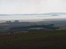
Bridgwater Bay near the mouth of the River Parrett | |
 Location within Somerset | |
| Area of Search | Somerset |
|---|---|
| Grid reference | ST290480 |
| Coordinates | 51°13′00″N 3°17′00″W / 51.2166°N 3.2833°WCoordinates: 51°13′00″N 3°17′00″W / 51.2166°N 3.2833°W |
| Interest | Biological |
| Area | 3,574.1 hectares (35.741 km2; 13.800 sq mi) |
| Notification | 1989 |
| Natural England website | |

Bridgwater Bay is on the Bristol Channel, 5 kilometres (3.1 mi) north of Bridgwater in Somerset, England at the mouth of the River Parrett and the end of the River Parrett Trail. It consists of large areas of mud flats, saltmarsh, sandflats and shingle ridges, some of which are vegetated. It has been designated as a Site of Special Scientific Interest since 1989,[1] and is designated as a wetland of international importance under the Ramsar Convention.[2] The risks to wildlife are highlighted in the local Oil Spill Contingency Plan.[3]
In addition to the rivers, Parrett, Brue and Washford several of the man-made drainage ditches, including the River Huntspill, from the Somerset Levels, including the "Pawlett Hams", also drain into the bay.
Geography

The Bay occupies the sweeping arc of coastline between the wave-cut platform of Jurassic Blue Lias at the northern tip of the Quantock Hills and the cliffs of Carboniferous Dolomites and Limestone at Brean Down which project into the Severn Estuary and provide some degree of protection from the erosive tidal currents. Strong prevailing westerly winds have thrown up sand dunes at Berrow and a shingle ridge at Steart. On the beach near Stogursey are the remains of a submerged forest dated to 2500 B.C.[4] - 6500 BC.[5]
Brean Down is a promontory marking the eastern end of the bay. Made of carboniferous limestone, it is a continuation of the Mendip Hills, and two further continuations are the small islands of Steep Holm and Flat Holm. It is owned by the National Trust, and is rich in wildlife, history and archaeology, as well as being a Site of Special Scientific Interest in its own right.[6] There are steep cliffs and, at its seaward point, Brean Down Fort built in 1865 and then re-armed in the Second World War. There is evidence of an Iron Age hill fort and prehistoric barrows and field systems[7] and a pagan shrine dating from pre-Roman times[8] which was re-established as a Romano-Celtic style temple in the mid-4th century and probably succeeded by a small late-4th century Christian oratory.[9] In 1897, following wireless transmissions from Lavernock Point in Wales and Flat Holm, Guglielmo Marconi moved his equipment to Brean Down and set a new distance record for wireless transmission.
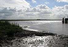
At low tide large parts of the bay become mud flats, 4 kilometres (2.5 mi) wide, due to the tidal range of 15 metres (49 ft),[10] second only to Bay of Fundy in Eastern Canada.[11][12] The intertidal mud flats are, as a result, potentially dangerous and it is not uncommon for the emergency services to mount rescue operations. Following the death of Lelaina Hall off Berrow in 2002, a local fund raising campaign succeeded in purchasing a Swedish-built BBV6 rescue hovercraft. The hovercraft is operated by BARB in Burnham-on-Sea. Much of the coastline within the western part of the reserve is accessible via a waymarked public footpath,[13] and the South West Coast Path begins at Minehead at the western end of the bay.
Hinkley Point is a headland extending into Bridgwater Bay 5 miles (8.0 km) west of Burnham-on-Sea, close to the mouth of the River Parrett. The landscape of Hinkley Point is dominated by two nuclear power stations: Hinkley Point A - Magnox (now closed) and Hinkley Point B - AGR. A third, twin-unit European Pressurized Reactor (EPR) reactor is planned, and will become Hinkley Point C.[14]
Man made sea defenses include a sea wall at Burnham-on-Sea and a 3 kilometres (1.9 mi) section south from Brean Down. There is also an isolated fossil aeolian sand dune belt fronted by a salt marsh deliberately planted in 1928.[15] There are some concerns that the proposed Severn Barrage could leave some sites high and dry, and others permanently under water.[16] The Steart Peninsula has flooded many times during the last millennium. The most severe recent floods occurred in 1981. By 1997, a combination of coastal erosion, sea level rise and wave action had made some of the defences distinctly fragile and at risk from failure. As a result, in 2002 The Environment Agency produced the Stolford to Combwich Coastal Defence Strategy Study to examine options for the future.[17]
The foreshore at Watchet, which lies at the mouth of the Washford River, and on the edge of Exmoor National Park, is rocky, but has a small harbour. The cliffs between Watchet and Blue Anchor show a distinct pale, greenish blue colour, resulting from the coloured alabaster found there. The name "Watchet" or "Watchet Blue" was used in the 16th century to denote this colour.[18][19]
East Quantoxhead used to have a small harbour which brought in limestone for local limekilns and exported alabaster. It is thought that it was also used for smuggling.[20]
At Kilve are the remains of a red brick retort, built in 1924, when it was discovered that the shale found in the cliffs was rich in oil. The beach is part of the Blue Anchor to Lilstock Coast SSSI (Site of Special Scientific Interest). Along this coast the cliffs are layered with compressed strata of oil-bearing shale and blue, yellow and brown lias embedded with fossils. In 1924 Dr Forbes-Leslie founded the Shaline Company to exploit them. This retort house is thought to be the first structure erected here for the conversion of shale to oil but the company was unable to raise sufficient capital and this is now all that remains of the anticipated Somerset oil boom.[21]
Fishing

The intertidal mud flats of the bay have a long history of use for fishing, with structures on Stert Flats being dated by dendrochronological analysis to between 932 and 966.[5] It is the last site in England used for 'mudhorse fishing' in which a wooden sledge is propelled across the mudflats to collect fish from nets.[16] Catches include: grey mullet, plaice, dogfish, cuttlefish, skate, shrimp, prawns, sea bass, and sole.[22]
Watchet Boat Museum displays the unusual local flatner boats which were used in the bay and associated artefacts.[23]
Ecology
At low tide extensive areas of mudflats (the Steart and the Berrow Flats) are exposed, providing important feeding and over-wintering grounds for waders (shorebirds). The ditches and ponds contain a diverse invertebrate fauna including six nationally rare species and eighteen nationally scarce species.[1] Consequently, Bridgwater Bay is a National Nature Reserve, and is managed by Natural England.[24]
The Site of Special Scientific Interest is designated as a wetland of international importance under the Ramsar Convention.[25] It is also a Nature Conservation Review Grade 1* site. The site is contiguous with the Brean Down, Berrow Dunes and Blue Anchor to Lilstock Coast SSSIs.[1]
Flora
Common cord-grass (Spartina anglica) dominates much of the seaward edge of the marsh, having vigorously invaded and consolidated the fronting mudflats, following plantings in the early 1900s.[26] The spartina is generally shorter in the bay than at other sites due to the high tides and the turbidity of the water, reaching around 30 centimetres (11.8 in) as opposed to 150 centimetres (59.1 in) elsewhere.[27] On higher ground common saltmarsh-grass (Puccinellia maritima) increases in abundance with sea aster (Aster tripolium). Where the land is ungrazed, common reed (Phragmites australis) often forms a zone above this. Where the upper marsh is grazed red fescue (Festuca rubra) and creeping bent (Agrostis stolonifera) are found. Sea couch (Elymus pycnanthus) and sea club-rush (Scirpus maritimus) occur at the landward edge of the marsh.[1]
High level sheep-grazed marshes carry populations of the nationally scarce bulbous foxtail (Alopecurus bulbosus), slender hare's-ear (Bupleurum tenuissimum) and sea barley (Hordeum marinum) while Stert Island is known to support the nationally rare compact brome (Bromus madritensis) and nationally scarce Ray's knotgrass (Polygonum oxyspermum).[1]
A wide variety of aquatic and bankside plant species occur in the ditches including the nationally restricted rootless duckweed (Wolffia arrhiza), together with uncommon species such as frogbit (Hydrocharis morsus-ranae) and water fern (Azolla filiculoides). The slightly brackish nature of the water is indicated by the presence of plants such as the nationally restricted brackish water-crowfoot (Ranunculus baudotii) and sea clubrush (Scirpus maritimus).[1]

Brean Down is a site for the nationally rare white rock-rose (Helianthemum apenninum), which occurs in abundance on the upper reaches of the grassy south-facing slopes.[28] Some of the broomrapes growing here which were originally thought to be oxtongue broomrape (Orobanche artemisiae-campestriae) are now no longer believed to be this species, but atypical specimens of ivy broomrape (Orobanche hederae) [29] Other plants on the southern slopes include the Somerset hair grass, wild thyme, horseshoe vetch and birds-foot-trefoil. The northern side is dominated by bracken, bramble, privet, hawthorn, cowslips and bell heather.
Fauna
Five Red Data Book invertebrate species have been recorded: the great silver water beetle (Hydrophilus piceus), the water beetle Hydrovatus clypealis, the hover fly Lejops vittata, and the soldier flies Odontomyia ornata and Stratiomys singularior. Nationally scarce species include the aquatic snail Gyraulus laevis, the hairy dragonfly (Brachytron pratense), and the ladybird Coccidula scutellata.[1]
Bridgwater Bay is a critical feeding ground for passage and over-wintering waders and wildfowl, with approximately 190 species recorded on the reserve.[2] It supports internationally important numbers of whimbrel (Numenius phaeopus) and black-tailed godwit (Limosa limosa) and nationally important numbers of dunlin (Calidris alpina) and wigeon (Anas penelope).[1] In early winter the wigeon select Puccinellia maritima in preference to Agrostis stolonifera and Festuca rubra.[30] Avocets have become regular autumn and winter visitors to the area in recent years, favouring the lower reaches of the River Parrett.
Rare vagrant species spotted in the area include Wilson's phalarope, lesser yellowlegs, white-rumped sandpiper, spotted sandpiper, Montagu's harrier (in spring), ortolan bunting and Richard's pipit (in autumn).
The birds seen on Brean Down include peregrine falcon, jackdaw, kestrel, collared and stock doves, whitethroat, linnet, stonechat, dunnock and rock pipit. There are also several species of butterfly, including chalkhill blue, dark green fritillary, meadow brown, marbled white, small heath, and common blue.
References
- 1 2 3 4 5 6 7 8 "SSSI citation sheet" (PDF). Sites of Special Scientific Interest. English Nature. Retrieved 12 November 2008.
- 1 2 "Bridgwater Bay NNR". National Nature Reserves. Natural England. Retrieved 14 November 2010.
- ↑ "Oil spill contingency plan". Sedgemoor Council. Retrieved 13 November 2008.
- ↑ "Stogursey". Victoria County History. British History Online. Retrieved 14 November 2008.
- 1 2 "Severn Estuary rapid coastal zone assessment" (PDF). English Heritage. Retrieved 14 November 2008.
- ↑ "Brean Down" (PDF). English Nature. Retrieved 2008-03-24.
- ↑ Adkins, Lesley and Roy (1992). A field Guide to Somerset Archeology. Stanbridge: Dovecote press. ISBN 0-946159-94-7.
- ↑ Dunning, Robert (1983). A History of Somerset. Chichester: Phillimore & Co. ISBN 0-85033-461-6.
- ↑ Aston, Mick; Burrow, Ian (1982). The Archaeology of Somerset. Taunton: Somerset County Council.
- ↑ "Severn Estuary Barrage". UK Environment Agency. 31 May 2006. Archived from the original (PDF) on 2007-09-30. Retrieved 2007-09-03.
- ↑ Chan, Marjorie A.; Archer, Allen William (2003). Extreme Depositional Environments: Mega End Members in Geologic Time. Boulder, Colorado: Geological Society of America. p. 151. ISBN 0-8137-2370-1.
- ↑ "Coast: Bristol Channel". BBC. Retrieved 2007-08-27.
- ↑ "Bridgwater Bay National Nature Reserve". Breathing Places. BBC. Retrieved 13 November 2008.
- ↑ "New dawn for UK nculear power". WNN. 2008-09-24. Retrieved 2008-09-25.
- ↑ Kirby, R (2002). "Management Operations for the Bridgwater Bay shoreline" (PDF). Occasional papers in Geography. Bath Spa University. Retrieved 14 November 2008.
- 1 2 "Matt Baker goes mad for mud, fish and relics in Bridgwater Bay.". Open Country. BBC. Retrieved 14 November 2008.
- ↑ "Stolford to Combwich Coastal Defence Strategy Study" (PDF). Environment Agency. Archived from the original (PDF) on 2007-09-27. Retrieved 2007-10-31.
- ↑ Leete-Hodge, Lornie (1985). Curiosities of Somerset. Bodmin: Bossiney Books. p. 41. ISBN 0-906456-98-3.
- ↑ "Article from Issue Number 12/1 February 2005". Open University Geological Society (London Branch). Retrieved 2008-10-08.
- ↑ Farr, Grahame (1954). Somerset Harbours. London: Christopher Johnson. pp. 123–124.
- ↑ "Oil retort house". Images of England. Retrieved 2007-10-07.
- ↑ Fort, Matthew (2008-05-21). "Around Britain with a fork". The Guardian. Guardian Newspapers. Retrieved 13 November 2008.
- ↑ "Watchet". West Somerset Railway. Retrieved 2008-10-10.
- ↑ "Bridgwater Bay NNR". Natural England. Retrieved 2010-01-31.
- ↑ "Bridgwater Bay NNR". National Nature Reserves. Natural England. Retrieved 13 November 2008.
- ↑ "Visiting Steart". Burnham on Sea.com. Retrieved 13 November 2008.
- ↑ Morley, J.V. (July 1973). "Tidal Immersion of Spartina Marsh at Bridgwater Bay, Somerset". The Journal of Ecology. 61 (2): 383–386. doi:10.2307/2259033. JSTOR 2259033.
- ↑ Twist, Colin, Rare Plants in Great Britain - a site guide
- ↑ Green, Ian, Peter Green and Geraldine Crouch The Atlas Flora of Somerset
- ↑ Owen, Myrfyn (April 2008). "The winter feeding ecology of Wigeon at Bridgwater Bay, Somerset". Ibis. 115 (2): 227–243. doi:10.1111/j.1474-919X.1973.tb02639.x. Retrieved 2008-11-13.