Bridgeport Covered Bridge
| Bridgeport Covered Bridge | |
|---|---|
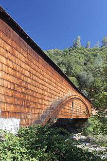 View of the Bridgeport Covered Bridge | |
| Carries | Pedestrian |
| Crosses | South Yuba River |
| Locale | Nevada County, California |
| Characteristics | |
| Design | Howe truss with auxiliary arch covered bridge[1] |
| Total length | 233 feet (71 m)[1] |
| Longest span | 208 feet (63 m)[2] |
| Load limit | 13 Tons (Current estimate at 3 tons due to age of timbers) |
| History | |
| Designer | David Ingefield Wood[1] |
| Opened | 1862[1] |
|
Bridgeport Covered Bridge | |
 | |
| Nearest city | French Corral, CA |
| Coordinates | 39°17′33.86″N 121°11′41.66″W / 39.2927389°N 121.1949056°WCoordinates: 39°17′33.86″N 121°11′41.66″W / 39.2927389°N 121.1949056°W |
| Built | 1862[2] |
| Architectural style | Howe Truss with an auxiliary Burr Arch Truss[2] |
| NRHP Reference # | 71000168 |
| CHISL # | 390[3] |
| Added to NRHP | July 14, 1971[4] |
The Bridgeport Covered Bridge is located in Bridgeport, Nevada County, California, southwest of French Corral and north of Lake Wildwood. It is used as a pedestrian crossing over the South Yuba River. The bridge was designed by David Ingefield Wood, and built in 1862. Its lumber came from Plum Valley in Sierra County, California.[5] The bridge was closed to vehicular traffic in 1972 and pedestrian traffic in 2011 due to deferred maintenance and "structural problems".[6]
On June 20, 2014, California Gov. Jerry Brown signed budget legislation that included $1.3 million for the bridge's restoration. The work is slated to be done in two phases—near-term stabilization followed by restoration. Restoration may not begin until 2018.[7]
The Bridgeport Covered Bridge has the longest clear span of any surviving covered bridge in the world.[1][8]
Historic landmark
The bridge was listed in the National Register of Historic Places in 1971,[4] and it is also a California Registered Historical Landmark No. 390.[3] There are three plaques at the site.
The inscription on the marker placed in 1964 reads:
"Built in 1862 by David Isaac John Wood with lumber from his mill in Sierra County, this bridge was part of the Virginia Turnpike Company toll road which served the northern mines and the busy Nevada Comstock Lode. Utilizing a combination truss and arch construction, it is one of the oldest housed spans in the west and the longest single-span wood-covered bridge in the United States."[9]
The bridge was an important link in a freight-hauling route that stretched from the San Francisco Bay to Virginia City, Nevada and points beyond after the discovery of the Comstock Lode in 1859 sparked a mining boom in Nevada. Steamboats carried freight from the San Francisco Bay up the Sacramento River to Marysville, where it was loaded onto wagons for the trip across the Sierra Nevada via the Virginia Turnpike, and Henness Pass Road. The route across the bridge was ultimately eclipsed by the completion of the First Transcontinental Railroad as far as Reno in 1868 via Donner Pass, but it continued to serve nearby communities in the foothills until improved roads and bridges on other routes drew away most of the traffic.
Longest span
A report by the U.S. Department of the Interior states that the Bridgeport Covered Bridge (HAER No. CA-41) has clear spans of 210 feet (64 m) on one side and 208 feet (63 m) on the other, while Old Blenheim Bridge (HAER No. NY-331) had a documented clear span of 210 feet (64 m) in the middle (1936 HABS drawings).[10]
With the 2011 destruction of the Old Blenheim Bridge, the Bridgeport Covered Bridge is the undisputed longest-span wooden covered bridge still surviving. Historically, the longest single-span covered bridge on record was Pennsylvania's McCall's Ferry Bridge with a claimed clear span of 360 feet (110 m) (built 1814–15, destroyed by ice jam 1817).[10]
See also
External links
- Bridgeport Covered Bridge, at Nevada County, California website
- Pictures of the Bridgeport Covered Bridge, at California Dept. of Transportation
- South Yuba River State Park
- Historic American Buildings Survey (HABS) No. CA-1401, "Covered Bridge"
- Historic American Engineering Record (HAER) No. CA-41, "Bridgeport Covered Bridge"
- Bridgeport Covered Bridge at the Covered Spans of Yesteryear website
- South Yuba River Park Adventures, pictures, events, maps, wildflowers
References
- 1 2 3 4 5 Jackson, Donald C. (1988). Great American Bridges and Dams. Wiley. pp. 268–269. ISBN 0-471-14385-5.
- 1 2 3 "Bridgeport Covered Bridge". Historic American Engineering Record (HAER) No. CA-41. 1985-01-01.
- 1 2 3 "Bridgeport Covered Bridge". Office of Historic Preservation, California State Parks. Retrieved 2012-10-10.
- 1 2 National Park Service (2007-01-23). "National Register Information System". National Register of Historic Places. National Park Service.
- ↑ "California Historical Landmarks in Nevada County". noehill.com. Retrieved 2009-05-28.
- ↑ Historic Bridgeport Bridge to close - Appeal-Democrat
- ↑ State budget includes money to restore Bridgeport Covered Bridge - Transportation - The Sacramento Bee
- ↑ The Nevada County, California website Archived May 9, 2008, at the Wayback Machine. that claims Bridgeport Covered Bridge has a longer span than the Old Blenheim Bridge had, also claims it is a National Historic Landmark. While the National Historic Landmark search system does not report on the existence of this bridge as a National Historic Landmark. It is a California Historical Landmark and listed at the National Register of Historic Places.
- ↑ "Bridgeport (Nyes Crossing) Covered Bridge". HISTORICAL MARKER DATABASE. Retrieved 2008-08-03.
- 1 2 Bennett, Lola (2002–2003). "Blenheim Bridge". National Covered Bridges Recording Project. Historic American Engineering Record (HAER) No. NY-331.