Bretby
Coordinates: 52°48′14″N 1°33′58″W / 52.804°N 1.566°W
| Bretby | |
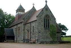 St Wystan's Church at Bretby |
|
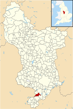 Bretby parish highlighted within Derbyshire |
|
| Population | 893 (2011) |
|---|---|
| OS grid reference | SK293230 |
| District | South Derbyshire |
| Shire county | Derbyshire |
| Region | East Midlands |
| Country | England |
| Sovereign state | United Kingdom |
| Post town | BURTON ON TRENT |
| Postcode district | DE15 |
| Police | Derbyshire |
| Fire | Derbyshire |
| Ambulance | East Midlands |
| EU Parliament | East Midlands |
|
|
Bretby is a village and civil parish in the south of Derbyshire, England, north of Swadlincote and east of Burton upon Trent, on the border between Derbyshire and Staffordshire. The population of the civil parish at the 2011 Census was 893.[1] The name means "dwelling place of Britons". There is a secondary settlement known as Stanhope Bretby - this was the site of Bretby Colliery.[2]
History
Bretby is believed to be the site of a major battle between the Danes and Kingdom of Mercia in AD880.
This manor (Bretebi) was in the Domesday Book in 1086. Under the title of “The land of the King (in Derbyshire[3]” it said:
In Newton Solney and Bretby Ælfgar had seven carucates of land to the geld. There is land for six ploughs. There the king has one plough and nineteen villans and one bordar with five ploughs. There are 12 acres (49,000 m2) of meadow, woodland pasture two leagues long and three furlongs broad. TRE[4] as now worth one hundred shillings.[5]

In 1209, Ranulph de Blondeville, 4th Earl of Chester granted the manor of Bretby to Stephen de Segrave[6] who built a church and a mansion there. There was also Bretby Castle which was destroyed during the reign of King James I of England to make way for the construction of Bretby Hall.[2]
In 1585, Thomas Stanhope bought the manor house which was known as Bretby Hall and from then on was the home of the Earls of Chesterfield. This house had a formal garden that rivalled the garden of the Palace of Versailles in the 1640s. Lord Carnarvon sold the property in the 1920s to pay for the Tutankamun expedition.
Today
Today the village is centred by a village green. Overlooking the green is a residential house which records that it was called 'Bradby School' when it was built. A stone records "BRADBY SCHOOL/OPENED FOR THE ADMISSION OF SCHOLARS/OCTOBER 20th 1806."
The school building is a Grade II listed building.[7]
Notable residents
- Major General Frank Roberts VC DSO OBE MC, British Army officer and Victoria Cross recipient, died in Stanhope Bretby in 1982. He was cremated at nearby Bretby crematorium and his ashes buried in Bretby churchyard. He was awarded the Victoria Cross during the First World War in 1918.[8]
- Actor, director and musician Paddy Considine had an apartment at Bretby Hall until 2007.
References
| Wikimedia Commons has media related to Bretby. |
- ↑ "Civil Parish population 2011". Neighbourhood Statistics. Office for National Statistics. Retrieved 21 March 2016.
- 1 2 Bretby at DerbyshireUK
- ↑ The King had a number of manors in Derbyshire. Besides Bretby and Newton Solney he had a list that included Repton, Milton, Wirksworth, Weston-on-Trent, Walton-on-Trent and Ashbourne.
- ↑ TRE in Latin is Tempore Regis Edwardi. This means in the time of King Edward before the Battle of Hastings.
- ↑ Domesday Book: A Complete Translation. London: Penguin, 2003. ISBN 0-14-143994-7 p.744
- ↑ In 1209.PDF South Derbyshire site - Grant of Bretby Archived September 27, 2007, at the Wayback Machine., p.1
- ↑ Images of England
- ↑ Burial location of VC holders - Derbyshire.