Branchville, Alabama
| Branchville, Alabama | |
|---|---|
| Town | |
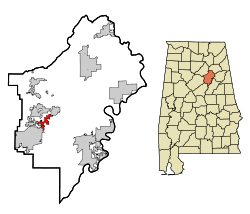 Location in St. Clair County and the state of Alabama | |
| Coordinates: 33°38′52″N 86°26′12″W / 33.64778°N 86.43667°W | |
| Country | United States |
| State | Alabama |
| County | St. Clair |
| Area | |
| • Total | 3.1 sq mi (7.9 km2) |
| • Land | 3.1 sq mi (7.9 km2) |
| • Water | 0 sq mi (0 km2) |
| Elevation | 791 ft (241 m) |
| Population (2007)[1] | |
| • Total | 993 |
| • Density | 266.1/sq mi (104.4/km2) |
| Time zone | Central (CST) (UTC-6) |
| • Summer (DST) | CDT (UTC-5) |
| ZIP code | 35120 |
| Area code(s) | 205 |
| FIPS code | 01-08920 |
| GNIS feature ID | 0164576 |
Branchville is a former town in St. Clair County, Alabama in the United States. As of the 2000 census, the population of the town was 825.
Current status
It was incorporated in 1968. Citizens voted to dissolve the town in 2007 and the community was annexed into the neighboring town of Odenville.[2]
Geography
Branchville is located at 33°38′53″N 86°26′13″W / 33.64806°N 86.43694°W (33.648029, -86.436895).[3]
According to the U.S. Census Bureau, the town has a total area of 3.1 square miles (8.0 km2), all land.
Demographics
| Historical population | |||
|---|---|---|---|
| Census | Pop. | %± | |
| 1970 | 225 | — | |
| 1980 | 365 | 62.2% | |
| 1990 | 370 | 1.4% | |
| 2000 | 825 | 123.0% | |
| U.S. Decennial Census[4] | |||
As of the census[5] of 2000, there were 825 people, 319 households, and 256 families residing in the town. The population density was 269.6 people per square mile (104.1/km2). There were 345 housing units at an average density of 112.7 per square mile (43.5/km2). The racial makeup of the town was 97.09% White, 0.36% Black or African American, 1.21%, 0.48% from other races, and 0.85% from two or more races. 1.94% of the population were Hispanic or Latino of any race.
There were 319 households out of which 30.4% had children under the age of 18 living with them, 67.4% were married couples living together, 9.7% had a female householder with no husband present, and 19.7% were non-families. 18.2% of all households were made up of individuals and 11.0% had someone living alone who was 65 years of age or older. The average household size was 2.59 and the average family size was 2.90.
In the town the population was spread out with 25.2% under the age of 18, 5.7% from 18 to 24, 27.9% from 25 to 44, 26.3% from 45 to 64, and 14.9% who were 65 years of age or older. The median age was 40 years. For every 100 females there were 92.3 males. For every 100 females age 18 and over, there were 94.6 males.
The median income for a household in the town was $40,438, and the median income for a family was $43,594. Males had a median income of $35,313 versus $32,639 for females. The per capita income for the town was $20,541. About 6.5% of families and 7.8% of the population were below the poverty line, including 10.1% of those under age 18 and 5.3% of those age 65 or over.
References
- ↑ "Annual Estimates of the Population for Incorporated Places in Alabama". United States Census Bureau. 2008-07-10. Archived from the original on 2008-08-01. Retrieved 2008-07-14.
- ↑ http://www.bhamwiki.com/w/Branchville
- ↑ "US Gazetteer files: 2010, 2000, and 1990". United States Census Bureau. 2011-02-12. Retrieved 2011-04-23.
- ↑ "U.S. Decennial Census". Census.gov. Archived from the original on May 11, 2015. Retrieved June 6, 2013.
- ↑ "American FactFinder". United States Census Bureau. Archived from the original on 2013-09-11. Retrieved 2008-01-31.
Coordinates: 33°38′53″N 86°26′13″W / 33.648029°N 86.436895°W
Municipalities and communities of St. Clair County, Alabama, United States | ||
|---|---|---|
| Cities | 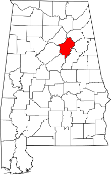 | |
| Towns | ||
| Unincorporated communities | ||
| Former towns | ||
| Footnotes | ‡This populated place also has portions in an adjacent county or counties | |