Bradgate Park
| Bradgate Park | |
|---|---|
|
Rocks, Old John and the War Memorial | |
 Bradgate Park
| |
| Type | Medieval Deer Park |
| Location | Leicestershire, UK |
| Nearest city | Leicester |
| OS grid | SK529107 |
| Coordinates | 52°41′30″N 1°13′17″W / 52.6917°N 1.2214°WCoordinates: 52°41′30″N 1°13′17″W / 52.6917°N 1.2214°W |
| Area | 850 acres (340 ha) |
| Elevation | 690 ft (210 m) |
| Created | 1500 (Public Park from 1928) |
| Operated by | Bradgate Park and Swithland Wood Charity (Registered Charity no. 521476, (popularly known as the Bradgate Park Trust) |
| Visitors | 900,000[1] |
| Open | all year, 7.45 am to dusk |
| Website |
www |


Bradgate Park (local pronunciation: /ˌbrædɡʌt/)is a public park in Charnwood Forest, in Leicestershire, England, northwest of Leicester. It covers 850 acres (340 hectares). The park lies between the villages of Newtown Linford, Anstey, Cropston, Woodhouse Eaves and Swithland. The River Lin runs through the park, flowing into Cropston Reservoir which was constructed on part of the park. To the north-east lies Swithland Wood. The park's two well known landmarks, Old John and the war memorial, both lie close to the 200 m contour.[2]
History
The area now enclosed as Bradgate Park was one of a number of parks surrounding Charnwood Forest. Since medieval times it has been part of the Manor of Groby.[3] In the reign of Edward the Confessor, the area was owned by Ulf. The manor, along with some 100 others in and around Leicestershire, was awarded to Hugh de Grandmesnil in the eleventh century as reward for his assistance in battle to William I.[4] The name Bradgate is thought to derive from Norse or Anglo-Saxon, meaning "broad road" or "broad gate" respectively.[4] The first mention of Bradgate Park is from 1241, by which time it was laid out as a hunting park, although rather smaller than the current boundary.[3] It was subsequently acquired by the Beaumont family, passing to the de Quincy family and on to William de Ferrers of Groby. It remained in the de Ferrers family until 1445, when it passed to the Grey family after William's only surviving daughter married Edward Grey.[4] The inquisition into the estates of de Ferrers, made after his death, mentions the park, with "herbage, pannage and underwood, worth 40 shillings yearly".[5] The Grey family retained it for the next 500 years, and in the 19th century was opened to the public several days a week.[6][7] In 1928 it was bought by Charles Bennion and given, as a plaque in the park describes, 'to be preserved in its natural state for the quiet enjoyment of the people of Leicestershire'.
Medieval Deer Park
The park was originally enclosed using a bank and ditch topped by vertical pales of oak. These first ditchworks cross the River Lyn east of the Little Matlock Gorge. A parker, living in a moated house, was the only occupant, maintaining stocks of deer for the lord of Groby Manor to hunt.[3] The park was greatly extended by the first marquis in the late 15th century, to occupy land previously farmed by both Newtown Linford and the now lost village of Bradgate.[3] Lichen dating of the dry-stone walls suggest that the north and west boundary walls were built in the 17th and early 18th centuries, when Bradgate was still occupied by the earls of Stamford. The walled spinneys are a later feature, built and planted in the early 19th century as coverts for shooting.[4] The park still has herds of red and fallow deer, which probably have an unbroken occupancy since medieval times.[3]
Bradgate House
Edward Grey's son Sir John Grey of Groby married Elizabeth Woodville, who after John's death married King Edward IV. Their son Thomas Grey, 1st Marquess of Dorset prepared for building Bradgate House in the late fifteenth century but died before he was able to begin. It was his son Thomas Grey, 2nd marquis of Dorset who built Bradgate House, the likely completion date being 1520.[8]


Old John
A prominent landmark is the folly known as 'Old John' on the top of the highest hill in the park. Built by the Greys in 1784, the folly is, by local legend, a memorial to John, an estate worker killed in a bonfire accident during celebrations of the 21st birthday of the future eighth Earl of Stamford. It is reputed that the stonework at the side of the tower was altered to look like a handle, perhaps knowing John's liking of ale.[9] However he was not 21 until 1786, and a map of 1745 names the hill as 'Old John'. The tower was used during the 19th century as a viewing point for the horse-racing practice circuit laid out by the seventh earl.
Cropston Reservoir
Cropston Reservoir was constructed in the south-east corner of the park in 1871, submerging the Head Keeper's house[4] and a substantial area of former parkland.[3] It was Leicester's second reservoir (after Thornton), built in response to the 1831 and 1841 cholera epidemics. The water level was raised 2 feet (60 centimetres) in 1887, to increase capacity and the original steam powered beam engines ran until 1956.[10] A number of pools were also constructed along the course of the River Lin through the park, to allow silt to settle before reaching the reservoir.[4] A second, covered reservoir was added on the northern side of the park in the early 1960s.[4]
Public Park
In 1905 the estate was bequeathed on the death of the 7th Earl of Stamford's wife to the earl's niece, Mrs Arthur Duncombe. Limited public access had been allowed while the park was in the hands of the Greys. In 1928, the ancient Deer Park with the ruins of Bradgate House was included in the sale of the whole Grey estate and the Park was bought by local businessman and British United Shoe Machinery founder Charles Bennion who gave it in perpetuity to the people of the Leicestershire. Plaques on Old John and the main path through the park commemorate the gift. The nearby Swithland Wood had previously been sold in 1921 to the Leicester timber merchant William Gimson, who began to extract the timber commercially, with the aim of dividing up the land for building plots as it was gradually cleared. Following public concern about the threatened loss of this ancient woodland of importance for its geological, natural history and industrial history features, in 1925 the Rotary Club of Leicester, with the cooperation of William Gimson, bought the whole site of approximately 137 acres (55 ha) for preservation and to provide access to the public for recreation "as a national heritage". The Rotary Club established the Swithland Wood Trust, repaired and renewed the fencing of the area, provided car parking and restored the paths, spending around £6,000 on the original purchase, fencing and landscaping. The Club opened Swithland Wood to the public on August Bank Holiday, 2 August 1925, employing its own staff to manage the Wood and visitor services. In 1928 the Club initiated the annual Bluebell Service in the Wood, in partnership with Swithland Parish Church. On 29 December 1929 the Bradgate Park Charity with trustees nominated by the County Council and the National Trust was established to manage Charles Bennion's purchase and gift of Bradgate Park, with the appropriate senior officers of the Council providing the necessary professional and administrative services, including land management, legal, secretariat and financial support. Although there does not seem to have been a formal opening of Bradgate Park, public access to the Park became available soon afterwards in 1929. In 1931, once the Bradgate Park Trust was fully operational and established, the Rotary Club approached the County Council and trustees about the possibility of merging the two properties and charities under the Bradgate Park trustees and this was completed in 1931.[11] The park is now administered by the Bradgate Park and Swithland Wood Charitable Trust, with trustees nominated by Leicestershire County Council, Leicester City Council and the National Trust.[12] With the consent of the Charity Commission charity has adopted the shorter working title of Bradgate Park Trust.
Geology
.jpg)
The visible geology in Bradgate Park ranges from some of the oldest (Precambrian) rocks in England to the youngest (Quaternary). The rock outcrops were created in conditions varying from volcanos rising out of the ocean, to magma flowing deep underground and from tropical deserts to Ice sheets. Within the park the outcrops are widely distributed as hillside crags and outcrops, both along the valley sides of the River Lin and on the hilltop of Old John. They include rocks with some of the oldest known developed forms of fossil animal life in Western Europe.[13]
Precambrian rocks

The Precambrian outcrops include four 'type-members' of the Charnian Supergroup,[14] formed some 560 million years ago.[13] Bradgate is one of the few areas of Britain where these ancient basement rocks can be seen at the surface. The oldest of the Charnian rocks within Bradgate Park are the rocks nearest the Old John and memorial summits.[13] This is the Beacon Hill Formation. It appears to have formed in deep water, out of sediments of volcanic ash and other pyroclastic material, which were then subject to slumping and submarine flows, to create rocks with various degrees of stratification. The volcano itself was in the north-west of Charnwood Forest, and the whole area was in the southern tropic, off the coast of the continent of Gondwana. (A modern parallel might be the sea surrounding Montserrat.[13]) Some of the layers show great variation, showing how an initial volcanic eruption would result in larger sediments rapidly settling to create course-grained tuff, followed by settling of much finer material to form much smoother dust-tuffs – smooth light-grey to creamy coloured rocks seen to the north of Old John.[15] The various layers were subsequently deeply buried, subject to vast periods of mountain-building (orogeny), heat, pressure and erosion of overlying material, to expose the hard, jagged outcrops seen in the photograph.
Overlying the Beacon Hill Formation, but found a little further down the hillside to the south, are the Bradgate Formation beds, the most notable of which is the Sliding Stone Slump Breccia rocks. Forming a line of crags below Old John, these are laminated mudstones, with layers of sandstone, mainly of volcanic origin. The beds are substantially warped, contorted and folded. Many of the more intricate folds and 'sag' patterns are thought to have occurred while the sediments were unconsolidated and water saturated.[13] Suggested causes for these include slumping, earth tremors and fault-movements, trapped water or gases and volcanic bomb impacts.[13] Outcrops of other rocks of the Bradgate Formation are found further down the slope. These are younger than and stratigraphically above the breccia, but the uplift from ancient mountain-building, the dip of the beds and erosion of overlying rocks mean that the younger rocks are encountered at progressively lower altitudes.
The youngest of the Precambrian rocks are the South Charnwood Diorites. These are known locally as granite, (geologically they were formerly described as markfieldite) and are quarried commercially at Groby and Markfield. These are igneous intrusions of magma which formed within the existing Beacon Hill and Bradgate Formations. They cooled slowly and at great depth to create their large crystalline structure,[16] and were subsequently exposed by erosion of the uplifted rocks above. The Diorites are the cliffs and blocks seen along the Lin valley, through the so-called Little Matlock Gorge and near Bradgate House. They are massive blocky outcrops[15] made up of crystals of feldspar, quartz and mafic minerals.[13]
Cambrian Rocks
An area of rock overlooking Cropston Reservoir is of Hanging Rocks Formation, the only other example being at Hangingstone Hills, near the Outwoods, 4 km to the north. It is unclear if this is late Precambrian or early Cambrian. It is distinguished by conglomerates with well-rounded volcanic pebbles mostly 5–15 mm but some up to 100 mm in diameter, which may have been smoothed on a volcanic shoreline before being washed, along with much finer material, into deeper water. These are younger than the Bradgate Formation, but again at a lower altitude. A possibly explanation is that it formed in a channel cut into the existing sea floor, but a preferred conclusion is that movement along fault-lines has relocated it relative to its surrounding rocks. The relationship between the different outcrops in Bradgate are made more obscure by the overlying peat and Boulder clay, which mean the contacts between adjacent stratigraphic sequences are nowhere exposed.
Previously classed as precambrian, but now accepted as early Cambrian are the Brand Group of rocks which include Swithland Slate, locally important as a source of roof slates and gravestones. The nearby Swithland Wood has extensive outcrops and was one of the principal quarry areas until the mid 19th century.[16] Rocks close in age to the slate can be seen in the 'stable pit', a medieval quarry near Bradgate House. This outcrop is part of the Brand Group and is known as the Stable Pit Member, a Quartz arenite rock with a smooth glassy appearance.[13] A metre-wide dyke of diorite also runs through the exposed rocks of the quarry, possibly of late Ordovician age, which places it at a similar age to the Mountsorrel granite formations.[13]
Triassic rocks
During the Triassic period, some 350 million years after those ancient rocks were formed, they were exposed due to the erosion of the rocks above. By this point they were part of the Pangea supercontinent and desert conditions resulted in an accumulation of windblown Loess, which now forms the Mercia Mudstone Group. With the subsequent sinking of the East Midlands crust, these deposits became waterlogged and formed into red clay. It is this clay that was used to make the bricks for Bradgate House. The mudstone is only visible where it was extracted, across the stream from Bradgate House. However, it covers much of the valley floor around and beneath Cropston Reservoir, – demonstrating that the present Lin valley was also there 220 million years ago.[13]
Quaternary deposits
Bradgate Park and its surrounding areas were heavily overlain in the (geologically) recent past by glacial deposits of Boulder Clay. The Quaternary period includes the last ice age. As the ice melted, some 10,000 years ago, the solid material within the ice settled over the 'natural' rocks below. This material includes unsorted clay and sand particles, small and large pebbles and large stones and boulders. It travelled great distances within the ice sheets and glaciers, so individual rocks, whether on the ground, or within the great lengths of stone walls of the Park, may be local stone, or may be a specimen from northern Britain or even from northern Europe.
Precambrian fossils
The fossils at Bradgate and in other nearby Charnian rocks are the only known Precambrian fossils in Western Europe.[13] Until 1957 it had been thought that complex life forms and perhaps life itself began with the Cambrian Period and that all rocks older than this developed in a world without plants or animals. The 1957 discoveries, by Roger Mason, in rocks near Woodhouse Eaves, subsequently named in his honour as Charnia masoni, required a re-evaluation of when life began. It also resulted in the re-classification of other rocks in Southern Australia and Newfoundland, which have similar fossil marks. At Bradgate Park there are some 50 known examples. They mainly take the form of two-dimensional impressions of fronds and disks and have at various times been described as seaweed, jelly fish, corals or sea anemones. They are now described as belonging to the Ediacara biota, with no consensus on which kingdom, current or extinct, they should be placed.[13] The Bradgate examples include Bradgatia linfordensis and Charniodiscus concentricus as well as Charnia Masoni. Because of the risk of vandalism and damage, specific locations of these fossils are not disclosed and those wishing to investigate them should first of all seek the permission of the Bradgate Park Trust. None of the rocks in Bradgate Park should be chipped, hammered, or otherwise sampled, replicated or removed.
Flora and fauna
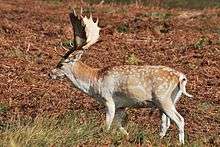
The landscape is rocky moorland with a covering of coarse grass and bracken. Several spinneys of woodland (pine and mixed deciduous) are enclosed by stone walls and are not accessible to the public. There are a number of magnificent specimens of ancient oaks several hundreds of years old. The park is home to herds of red deer and fallow deer. Birdlife is profuse – the reservoir attracts many species of wildfowl, as does the river and the spinneys provide secluded nesting areas for many other species, including large colonies of rooks. Species such as yellowhammer, reed bunting, skylark and meadow pipit are a common sight in the open areas of the park. Deadly nightshade is allowed to grow within the ruins of Bradgate House, having been originally established there during World War II by Leicester Polytechnic's School of Pharmacy for medicinal purposes.[4]
Dogs
As of 2015 deer numbers were around 450 but concerns have been raised about dogs chasing deer. The trust organizes monthly walks and advice on dog training.[17] Trust notices displaced at the entrances now advise that from June until October 2016 all dogs must be on a lead in specified areas near the main footpath. The Daily Telegraph highlighted Bradgate in an article referencing the busybodies charter though it failed to mention the deer.[18]
Information centres
In July 2016 a visitor centre named the Deer Barn opened off the main path west of Bradgate House. The geology section features details of the park's formation during its stages of volcanism, glacial erosion and inhabitation by Ediacara biota. It also shows the tracks of a later land based lizard. The archaeology section features work by Leicester University beginning in 2014 and includes evidence of Creswellian sites from 14,500 years ago. There is also a visitors' centre (with cafe) at Newtown Linford.
Access

There are pay car parks at the Hallgates entrance, Newtown Linford and Hunts Hill (at the top of the park near Old John). The park is open from dawn until dusk all year round, though the public footpaths which run through the area mean that in practice the park is always accessible. It is also possible to travel to the park by bus. Bus routes 120 timetable 120 stops near the park entrance in Newtown Linford, while 154 buses run between Leicester and Loughborough, travelling along Reservoir road, stopping within a short walk of the park's Hallgates entrance. There are two footpaths from the village of Anstey, easily accessible from Leicester by the 74 bus timetable 74. One path is directly opposite the bus stop on Link Road, between Cropston Road and Hazelhead Road. The path is signposted from Link Road and crosses several fields before entering the park proper. Another route, which joins the main path, is accessible from the edge of the village, adjacent to the last houses on Bradgate Road.
The park is within easy cycling distance from the city centre of Leicester.
References
- ↑ Bradgate Park Trust website Retrieved 13 April 2012
- ↑ Ordnance Survey Landranger maps 129 and 140
- 1 2 3 4 5 6 Squires, A.E. (1986). "Groby Manor – Bradgate Park". In Squires A.E. and Humphrey W. The Medieval Parks of Charnwood Forest. Sycamore Press.
- 1 2 3 4 5 6 7 8 Forsyth, Mary (1974) The History of Bradgate, The Bradgate Park Trust
- ↑ George Farnham Charnwood Forest and the Charnwood Manors (1928), quoting National Archives document C133/50/27.
- ↑ "Opening of Bradgate Park on Sunday". Leicester Chronicle. 18 July 1885. Retrieved 11 September 2014 – via British Newspaper Archive. (subscription required (help)).
- ↑ "Bradgate Park". Leicester Journal. 25 May 1860. Retrieved 11 September 2014 – via British Newspaper Archive. (subscription required (help)).
- ↑ Squires, Anthony (2002). The Greys: A Long and Noble Line. Silk Press Books. p. 41. ISBN 1-902685-10-5.
- ↑ "Old John – Bradgate Park". www.bradgatepark.org. Retrieved 2016-10-28.
- ↑ P Stubbs (2008). "Building Cropston Reservoir". Retrieved 31 January 2011.
- ↑ Woodward, Stephen (1992). Swithland Wood: A Study of its history and vegetation. Leicestershire Museums, Arts and Records Service.
- ↑ Charity Commission. The Bradgate Park and Swithland Wood Charity, registered charity no. 521476.
- 1 2 3 4 5 6 7 8 9 10 11 12 13 Carney, J.N. (2010). Guide to the Geology of Bradgate Park and Swithland Wood, Charnwood Forest (PDF). Occasional Report, OR/10/041. British Geological Survey. (This report includes two high quality geological maps)
- ↑ English Nature (1987). "English Nature citation for Bradgate Park's designation as a SSSI" (PDF). Retrieved 12 January 2011.
- 1 2 McGrath, Annette (2004). A Geological Walk around Bradgate Park and Swithland Wood. British Geological Survey on behalf of ODPM and MIRO. ISBN 0-85272-486-1.
- 1 2 Bedfordshire Geology Group (2008). "Bradgate Park Field Notes". Retrieved 12 January 2011.
- ↑ "Bradgate Park rangers warn: "Shooting a dog is the last thing we want to do - but we need to do something."". Leicester Mercury. 20 January 2015. Retrieved 22 January 2015.
- ↑ John Bingham (21 October 2016). "Dog walking banned in thousands of parks under 'busybodies' charter'". Daily telegraph. Retrieved 23 October 2016.
| Wikimedia Commons has media related to Bradgate Park. |