Brabrand Lake
| Brabrand Lake | |
|---|---|
 Brabrand Lake, stretching west. | |
| Location | Midtjylland |
| Coordinates | 56°08′42″N 10°07′12″E / 56.145°N 10.120°ECoordinates: 56°08′42″N 10°07′12″E / 56.145°N 10.120°E |
| Type | tunnel valley |
| Primary inflows | Aarhus River, Døde Å, Voldbækken, Lyngbygård Å, Madsesbæk, Kildebæk. |
| Primary outflows | Aarhus River |
| Catchment area | 282 km2 |
| Surface area |
2.53 km2 Brabrand Lake: 1.53 km2 Årselv Engsø: 1.00 km2 |
| Average depth |
Brabrand Lake: 1.1 m (3.6 ft) Årslev Engsø: 0.5 m (1.6 ft) |
| Max. depth |
Brabrand Lake: 2.7 m (8.9 ft) Årslev Engsø: 2 m (6.6 ft) |
| Shore length1 |
18km Brabrand Lake: 10km Årselv Engsø: 8 km |
| Surface elevation | 0.63 m (2.1 ft) |
| Settlements | Aarhus |
| 1 Shore length is not a well-defined measure. | |
Brabrand Lake (Danish: Brabrand-søen or Brabrand Sø) is a lake in the district of Brabrand (Gellerup), west of Aarhus city, Denmark. The Aarhus River passes through Brabrand Lake and it is possible to canoe all the way to the inner city from here. The lake is oblong-shaped.
Since 2003, Brabrand Lake has been steadily extended 3–4 km further west, with the new lake of Årslev Engsø (lit.: Årslev meadow lake). In 2001-2, it was politically decided, to abandon the artificial draining of the meadows and as of 2013, Årslev meadow lake has a surface area of around 100 hectares (250 acres). The total area including the adjoining meadows and reed beds sums up to 240 hectares (590 acres). It is expected that Eurasian bittern and otter, will find themselves a new home here with time.[1] In everyday parlance, "Brabrand Lake" is a general term including the surroundings as well, indicating a total area of around 560 hectares (1,400 acres) with 253 hectares (630 acres) for the lake alone.
A special Natura2000 protected area under the European Union,[2] Brabrand Lake is home to a large variety of birds and an important resting-place for migrating birds,[3] with several towers built to facilitate bird-watching. A public hiking trail surrounds the lake, whose landscape varies from wide meadows and reed beds to dense woods. The lake brinks are occupied by privately owned pastures, almost all the way around the lake, and are not publicly accessible, but public paths leading to the lake are scattered in between. There are several alottments near Brabrand Lake and it is a popular recreational place. It is a statutory goal of the Aarhus municipality to make the area publicly accessible and attractive for the citizens.[4]
Activities and sports

The pathway of Brabandstien (lit.: the Brabrand pathway) running along the Aarhus river from the inner city and around the lakes, was established by the City Council in 1956 as a labor project for the unemployed, to give the citizens better access to the green areas here. The pathway is 19 km long, with 10 km for the Brabrand Lake alone. With the addition of Årslev Engsø, the pathway grew with another 10 km. A large part of Brabrandstien is asphalted and is popular with cycling, rollerskating and jogging and some of the gravelled western parts are used for horse trotting. Cars are not allowed and motor vehicles are restricted. Brabrandstien is part of the Aarhus-Silkeborg hiking trail.[5][6][7]
On the northern banks of Brabrand Lake, lies the facilities of Brabrand Rostadion (Brabrand Rowing Stadium). The stadium was established in 1952 and has recently been heavily renovated and rebuild in the year 2010. C. F. Møller Architects was the architectural firm behind the new buildings.[8] Local rowing and kayaking clubs have used the lake for practicing and larger regattas for many years and now Rocenter Aarhus RCA (Rowingcentre Aarhus) are here, offering qualified training for rowers and clubs in East and South Jutland on all levels (including elite) and for all ages. There is a 2,000 m racing track on Brabrand Lake and it is generally perceived as very good for outrigger racing, but other boat-types are being rowed here as well, including kayaks.[9][10][11] Aarhus Roklub (Aarhus Rowing Club) have scored several prestigious medals. In 2005 Maria Pertl won silver in the World Rowing Championships in collaboration with Juliane Elander Rasmussen. In 2011 Andrej Lawaetz Bendtsen won gold at the WRC for seniors in a team of 4.[12]
Environmental projects
The lake is not very deep and has suffered from eutrophication for many years. The excessive nutrients originates from waste water and agricultural activities and poses a constant environmental threat to the surrounding ecology and the Bay of Aarhus. Eutrophication is a common problem all over the developed world. Starting in 1959 with 158 hectares, several environmental projects has aimed at alleviating the environmental burdens and at the same time maintaining the aesthetic value of the lake and surroundings. These projects includes mud pumping of the lake floor and willow afforestations. It is hoped that the rich fen ecology, that formerly characterized the lake and is a threatened type of nature, can be restored in the future.[2][13][14]
The groundwater beneath and adjoining Brabrand Lake, is very important, as it provides drinking water to more than 100,000 people in the greater Aarhus area. Acting partly on this fact, the lake water is also included in a large water treatment project led by the Aarhus Vand A/S (Aarhus Water) company. The project involves the Brabrand Lake, the Aarhus River and the Aarhus Bay and is budgeted at € 45 million. The project is almost finished as of 2013.[15][16]
Special flora and fauna
Many species of flora and fauna at Brabrand Lake, are either rare or relatively rare in Denmark and on the Danish Red List (under IUCN Red List). Some are also protected under different habitat directives of the EU. Here is a few examples:[3]
- Several Lathyrus species are growing here, like the tuberous pea which is rare in Denmark and the relatively rare marsh pea.
- Several relatively rare rush species are growing here, like European hard rush, heath rush and slender rush.
- Several orchids of the Dactylorhiza species are found growing here. Worthy of special mention is the common western marsh orchid and the relatively rare early marsh orchid, which are both to be protected and mentioned in the Danish Nature Protection Law ( §3) and the Washington Convention (list II.B). Although the w.m. orchid is one of the most common orchids in Denmark it is included, because of alarming population setbacks.
- The white storks resting here, are critically endangered (CR) and relatively rare in Denmark.
- The common nightingale living here is rare in Denmark. The thrush nightingale is common in Denmark though, and it is also found at the lake.
- The meadow lake regularly attracts rare birds like osprey (CR), white-tailed eagle (vulnerable VU), peregrine falcon (extinct as breeders RE), little gull (RE), mediterranean gull, black tern (endangered EN), caspian tern, spotted crake (near threatened NT), broad-billed sandpiper, red-necked phalarope og water pipit.
- The green hawker dragonflys are near threatened (NT) and rare in Denmark. They have been protected here under the EU habitat directive (IV) since 1992.
- The population of pond bats living at Brabrand Lake is protected under the Natura 2000 Plan 233.[17] Pond bats are endangered (EN) in western Europe, but maybe only near threatened on a global scale.[18]
Apart of the specialities, the Brabrand Lake area is characterized by the many common species living here. Mostly birds, insects and aquatic plants.
Archaeological finds
The area around Brabrand Lake have been populated for at least 6-7,000 years. In prehistoric times, Brabrand Lake was part of a deep brackish water fjord, offering natural protection and food in abundance. There were archaeological excavations here as early as 1903, revealing early Stone Age settlements and activities from the Ertebølle Culture. The Brabrand Lake area is still an active archaeological site today and have revealed Bronze Age settlements and Viking activities like a large shipbuilding yard. [19] [20] [21]
Gallery
 Eastward view from a birdwatching tower.
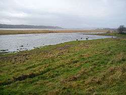
 Brabrand Lake on a grey foggy day in December.
 A berth.
 View across the new meadow lake of Årslev on a summers eve.
 Meadows with grazing cattle.
 The watchtower at the rowing stadium.
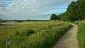 The gravelled hiking trail south of Årslev Engsø.
 Sunset, windy weather and rainclouds across the lake.
![]() Media related to Brabrand Lake at Wikimedia Commons
Media related to Brabrand Lake at Wikimedia Commons
![]() Media related to Årslev Engsø at Wikimedia Commons
Media related to Årslev Engsø at Wikimedia Commons
References
- ↑ "The Årslev Engsø project". Aarhus municipality.
- 1 2 "Natura2000 Plan 233". Danish Nature Agency.
- 1 2 "List of Species". Fugle&Natur (Naturbasen ApS and Natural History Museum Aarhus).
- ↑ Accessibility to urban-close nature Aarhus municipality
- ↑ Mogens Weinrich (13 November 2000). "The history of a pathway" (in Danish). Jyllands-Posten. Retrieved 18 August 2014.
- ↑ "A Layby at Brabrandstien" (in Danish). Aarhusportalen.dk. 7 July 2005. Retrieved 18 August 2014.
- ↑ Mogens Weinrich. "Hiking trail Aarhus-Silkeborg" (in Danish). Nature and Environment (Aarhus Municipality). Retrieved 18 August 2014.
- ↑ Brabrand Rostadion C. F. Møller
- ↑ The new 'Brabrand Rostadion' is inaugurated Thursday Aarhus Municipality (22.09.2010)
- ↑ Aarhus Rostadion, Brabrand A meta-site on the rowing activities associated with Brabrand Rostadion.
- ↑ Brabrand Rostadion Homepage under the Aarhus Studentclub
- ↑ WC gold to Aarhus rower Lokalavisen Aarhus (25th of July 2011)
- ↑ "Brabrand Lake". VisitDenmark. Retrieved 29 July 2013.
- ↑ "The struggle for life in Aarhus Bay". The Danish Society for Nature Conservation.
- ↑ The Aarhus Å project Archived October 21, 2013, at the Wayback Machine. Aarhus Vand A/S
- ↑ Safeguarding the Bathing Water Quality of the Stream Aarhus Å State of Green (English)
- ↑ "Habitat species (in Denmark)". Naturbasen ApS and Natural History Museum Aarhus.
- ↑ "The IUCN Red List on Pond Bats".(English)
- ↑ Haugsted, E. et al. (1947); "Bopladsen på Rugholm. Aarhus Museums Undersøgelser ved Østenden af Brabrand Sø 1944-45.". About the archaeological examinations of the Rugholm settlement. (Danish)
- ↑ Troels-Smith, J. (1937); "Pollenanalytisk Datering af Brabrand-Fundet.", Danmarks Geologiske Undersøgelser. IV Rk., Bd. 2, Nr. 16, s. 5-23. A pollen-analytical dating of archaeological finds near Brabrand Lake. (Danish)
- ↑ The Brabrand Fjord in the Stone Age (map) Jyllands Posten (COWI, Uffe Rasmussen, Moesgård Museum) (Danish)
External links
- Map of the lake area Aarhus Municipality
- Danish Ornithological Association (DOF) on Brabrand-Årslev Lake