Boxtel
| Boxtel | |||
|---|---|---|---|
| Town and municipality | |||
|
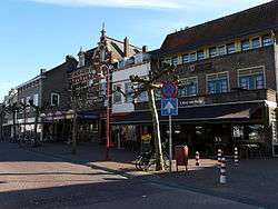
Boxtel town centre | |||
| |||
.svg.png) Location in North Brabant | |||
| Coordinates: 51°35′N 5°20′E / 51.583°N 5.333°ECoordinates: 51°35′N 5°20′E / 51.583°N 5.333°E | |||
| Country | Netherlands | ||
| Province | North Brabant | ||
| Government[1] | |||
| • Body | Municipal council | ||
| • Mayor | Mark Buijs (VVD) | ||
| Area[2] | |||
| • Total | 64.85 km2 (25.04 sq mi) | ||
| • Land | 63.75 km2 (24.61 sq mi) | ||
| • Water | 1.10 km2 (0.42 sq mi) | ||
| Elevation[3] | 8 m (26 ft) | ||
| Population (May 2014)[4] | |||
| • Total | 30,356 | ||
| • Density | 476/km2 (1,230/sq mi) | ||
| Demonym(s) | Boxelaar, Boxtelaar | ||
| Time zone | CET (UTC+1) | ||
| • Summer (DST) | CEST (UTC+2) | ||
| Postcode | 5280–5283, 5298 | ||
| Area code | 0411 | ||
| Website |
www | ||

Boxtel (Dutch pronunciation: [ˈbɔkstəl]) is a municipality and a town in the southern Netherlands.
This is the origin of the Van Boxtel family, which has numerous descendants in North Brabant.
The town was the site of the Battle of Boxtel fought in September 1794 during the Flanders campaign. It is often principally remembered as the first battle of the future Duke of Wellington.
Population centres
- Boxtel
- Lennisheuvel
- Liempde
Topography

Dutch Topographic map of Boxtel (place), March 2014.
Notable residents
- Bas van Erp, Paralympic wheelchair tennis medalist (2004)
- Michael van Gerwen, professional darts player
- Sam Feldt, DJ and producer
- José van Dijck, social media scholar
Transportation
References
- ↑ "Het college" [The board] (in Dutch). Gemeente Boxtel. Retrieved 7 May 2014.
- ↑ "Kerncijfers wijken en buurten" [Key figures for neighbourhoods]. CBS Statline (in Dutch). CBS. 2 July 2013. Retrieved 12 March 2014.
- ↑ "Postcodetool for 5281AT". Actueel Hoogtebestand Nederland (in Dutch). Het Waterschapshuis. Retrieved 7 May 2014.
- ↑ "Bevolkingsontwikkeling; regio per maand" [Population growth; regions per month]. CBS Statline (in Dutch). CBS. 26 June 2014. Retrieved 24 July 2014.
External links
 Media related to Boxtel at Wikimedia Commons
- Official website
 |
Haaren | Vught, Sint-Michielsgestel | | |
| Oisterwijk | |
Sint-Oedenrode | ||
| ||||
| | ||||
| Oirschot | Best |

This article is issued from Wikipedia - version of the 9/22/2016. The text is available under the Creative Commons Attribution/Share Alike but additional terms may apply for the media files.