Boulder Peak
This article is about the mountain in Montana. For the mountain in Washington state, see Boulder Peak (Washington).
| Boulder Peak | |
|---|---|
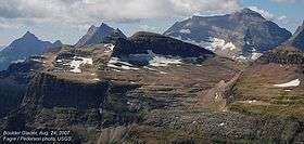 Boulder Peak above remnant Boulder Glacier in center foreground | |
| Highest point | |
| Elevation | 8,527 ft (2,599 m) [1] |
| Coordinates | 48°57′20″N 114°05′28″W / 48.95556°N 114.09111°WCoordinates: 48°57′20″N 114°05′28″W / 48.95556°N 114.09111°W[1] |
| Geography | |
| Location | Flathead County, Montana, U.S. |
| Parent range | Livingston Range |
| Topo map | USGS Mount Carter, MT |
Boulder Peak (8,527 feet (2,599 m)) is located in the Livingston Range, Glacier National Park in the U.S. state of Montana. The remnant Boulder Glacier is situated on the northern slopes of the mountain.[2]
See also
References
- 1 2 "Boulder Peak". Geographic Names Information System. United States Geological Survey. Retrieved 2010-08-07.
- ↑ "Boulder Peak, Montana" (Map). TopoQuest (USGS Quad). Retrieved 2010-08-07.
This article is issued from Wikipedia - version of the 12/23/2015. The text is available under the Creative Commons Attribution/Share Alike but additional terms may apply for the media files.