Bottomless Lakes State Park
| Bottomless Lakes State Park | |
| New Mexico State Park | |
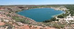 View of Lea Lake from the overlook above the lake | |
| Country | United States |
|---|---|
| State | New Mexico |
| County | Chaves County |
| Location | Roswell |
| - elevation | 3,500 ft (1,067 m) |
| - coordinates | 33°19′9″N 104°19′54″W / 33.31917°N 104.33167°WCoordinates: 33°19′9″N 104°19′54″W / 33.31917°N 104.33167°W |
| Area | 1,400 acres (570 ha) |
| Founded | 1933 [1] |
| Management | New Mexico State Parks Division |
| Owner | New Mexico State Park Division, State Land Office, Circle SP Ranch [1] |
 Location of Bottomless Lakes State Park in New Mexico
| |
Bottomless Lakes State Park is a state park in the U.S. state of New Mexico, located along the Pecos River, about 15 miles (24 km) southeast of Roswell. Established in 1933, it was the first state park in New Mexico.[2] It takes its name from nine small, deep lakes located along the eastern escarpment of the Pecos River valley. The escarpment is an ancient limestone reef, similar to the limestone mountains around Carlsbad Caverns, 80 miles (130 km) to the south. Caves formed within the limestone, and as the Pecos River eroded the escarpment, the caves eventually collapsed, leaving behind several deep, almost circular lakes known as cenotes.[3]
Lakes
Most of the nine lakes are almost completely surrounded by cliffs, with the notable exceptions being Lea Lake and Lazy Lagoon. Lea Lake has a large, sandy shoreline on the western side and tall cliffs on the eastern side. The cliffs around Lazy Lagoon have been completely eroded away by the Pecos River, and the lake sits in a former channel of the river.
Lazy Lagoon is the largest of the lakes, with a surface area of approximately 26.1 acres (10.6 ha). Although it is a single lake, it is made up of three separate sinkholes. The surface of the Lazy Lagoon is nearly level with the surrounding salt flats, which makes it look very shallow. Despite the name, the deepest of its three sinkholes is 90 feet (27 m) deep.[3][4]
Lea Lake is the only lake in which swimming is allowed. It has a beach and concession area that is popular in the summer.
Devil's Inkwell is the smallest lake with a surface area of 0.36 acres (0.15 ha). Its name stems from the water's dark color, caused by the steep sides of the cenote and algae growth within the lake.
In pure geologic terms, Figure Eight Lake is two lakes separated by a thin strip of land. When the water is very high the strip of land is covered, and the two nearly circular lakes join and take the shape of a figure eight. Irrigation in the Pecos Valley has lowered the water table, so the two lakes of Figure Eight lake rarely join to form a single lake anymore.
Pasture Lake is the shallowest lake at 18 feet (5.5 m) deep with a surface area of 0.76 acres (0.31 ha).
| Lake | Maximum depth | Surface area | Notes |
|---|---|---|---|
| Lazy Lagoon[3] | 90 feet (27 m) | 26.1 acres (10.6 ha) | Largest by area |
| Cottonwood Lake[3][4] | 27.5 feet (8.4 m) | 0.52 acres (0.21 ha) | |
| Mirror Lake (north)[3][4] | 32.8 feet (10.0 m) | 3 acres (1.2 ha) | |
| Mirror Lake (south)[3][4] | 43.3 feet (13.2 m) | 0.44 acres (0.18 ha) | |
| Devil's Inkwell[3][4] | 28.2 feet (8.6 m) | 0.36 acres (0.15 ha) | Smallest; dark algae color |
| Figure Eight Lake (north)[3] | 37 feet (11 m) | 1.46 acres (0.59 ha) | |
| Figure Eight Lake (south)[3] | 22 feet (6.7 m) | 0.76 acres (0.31 ha) | |
| Pasture Lake[3] | 18 feet (5.5 m) | 0.76 acres (0.31 ha) | Shallowest |
| Lost Lake[3] | — | 0.1 acres (0.040 ha) | "less than 1 acre (0.40 ha)"[3] |
| Lea Lake[3][4] | 90 feet (27 m) | 15 acres (6.1 ha) | Only lake allowing swimming. Daily spring
flow of about 2,500,000 US gallons (2,100,000 imp gal; 9,500 m3).[4] |
| Dimmitt Lake | — | 10 acres (4.0 ha) | Private lake made up of two basins covering about 10 acres (4.0 ha). |
The lakes are not fed by streams, and the evaporation rate of the lakes in the hot desert climate exceeds the rate at which rainwater refills them. The lakes are fed by underground water percolating through the rocks and into the lakes. The high evaporation rate produces brackish water in the lakes.
Seven of the lakes are protected, although in recent years the lakes have been contaminated by trash that has been thrown into the lakes by careless visitors. The ninth and southernmost lake, Dimmitt Lake, is not a part of the state park and is owned by the Fin and Feather Club, a local hunting and fishing club.
Wildlife
Four endangered species can be found in the park—the Pecos pupfish, the Rainwater Killifish, the Cricket Frog, and the Eastern Barking Frog.
In the winter, Devil's Inkwell and Cottonwood Lake are both stocked with Rainbow Trout.

See also
References
- 1 2 "Bottomless Lakes State Park Management and Development Plan" (PDF). New Mexico State Parks Division. 2001. Retrieved June 27, 2013.
- ↑ New Mexico State Parks Division. "Bottomless Lakes State Park". New Mexico Energy, Minerals and Natural Resources Department.
- 1 2 3 4 5 6 7 8 9 10 11 12 13 "NMBGMR Geologic Tour: Bottomless Lakes State Park". New Mexico Bureau of Geology & Mineral Resources. Retrieved June 27, 2013.
- 1 2 3 4 5 6 7 Davis, Danny R.; Joseph, Seva J. (1998), Water Quality Assessments for Selected New Mexico Lakes (PDF), New Mexico Environment Department, retrieved June 27, 2013