Boscombe railway station
| Boscombe | |
|---|---|
|
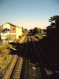
The site of the station, October 2007. | |
| Location | |
| Place | Boscombe |
| Area | Borough of Bournemouth |
| Operations | |
| Pre-grouping | London and South Western Railway |
| Post-grouping |
Southern Railway Southern Region of British Railways |
| Platforms | 2 |
| History | |
| 1 June 1897 | Station opened |
| 4 October 1965 | Station closed |
| Disused railway stations in the United Kingdom | |
|
Closed railway stations in Britain A B C D–F G H–J K–L M–O P–R S T–V W–Z | |
|
| |
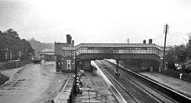
Boscombe railway station was a station in Bournemouth, now in the county of Dorset, England. It was opened in 1897 at which time the previous station with the name was renamed Pokesdown. The station served the Royal Victoria Hospital and the centre of Boscombe around the Royal Arcade. It was also the closest station to Dean Court, the home of the football club known during the station's life as Bournemouth and Boscombe Athletic FC. The station had a goods yard which received traffic from a large area of Bournemouth, and a large coal depot with sidings. It also had substantial brick buildings which were demolished a few years after closure. Closure took place, just before the electrification of the line through it, on 4 October 1965.
The Site Today
The area of the station yard is now occupied by a small industrial estate and the old coal yard awaits redevelopment. Trains on the South Western Main Line pass the piles of gravel that are all that remain of the platforms. These can still be seen alongside the line from the bridge that carries the Ashley Road over the line just to the west of the site.
There have been calls for the re-opening of the station by the Dorset Area Rail Transport System,[1] as well as by the Bournemouth Liberal Democrats.[2] A major reported stumbling block to reopening is the substantial cost of installing lifts to the tracks and extending the platforms to accommodate 10-car trains.[3]
| Preceding station | Disused railways | Following station | ||
|---|---|---|---|---|
| Pokesdown | British Rail Southern Region South Western Main Line |
Bournemouth | ||
References
Further reading
- Butt, R. V. J. (1995). The Directory of Railway Stations: details every public and private passenger station, halt, platform and stopping place, past and present (1st ed.). Sparkford: Patrick Stephens Ltd. ISBN 1-8526-0508-1. OCLC 60251199.
- Jowett, Alan (2000). Jowett's Nationalised Railway Atlas (1st ed.). Penryn, Cornwall: Atlantic Transport Publishers. ISBN 0-9068-9999-0. OCLC 228266687.
- Jowett, Alan (March 1989). Jowett's Railway Atlas of Great Britain and Ireland: From Pre-Grouping to the Present Day (1st ed.). Sparkford: Patrick Stephens Ltd. ISBN 1-8526-0086-1. OCLC 22311137.
- Station on navigable O.S. map
Coordinates: 50°43′51″N 1°50′23″W / 50.73082°N 1.83961°W