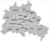
Boroughs and neighborhoods of Berlin

Berlin is both a city and one of Germany’s federal states (See: City state). Since a 2001 administrative reform, it is made up of twelve boroughs or districts (German: Bezirke, pronounced [bəˈtsɪʁkə]), each with its own local government, though all boroughs are subject to Berlin’s city and state government.
Each borough is governed by a council (Bezirksamt) with five councillors (Bezirksstadträte) and a borough mayor (Bezirksbürgermeister). The borough council is elected by the borough assembly (Bezirksverordnetenversammlung). The borough governments' power is limited, and subordinate to the Berlin Senate. The borough mayors form a council of mayors (Rat der Bürgermeister, led by the city's governing mayor), which advises the Senate.
History
Each borough is made up of several officially recognized subdistricts or neighborhoods (Ortsteile in German, sometimes called quarters in English). These neighborhoods typically have a historical identity as former independent cities, villages, or rural municipalities that were united in 1920 as part of the Greater Berlin Act, forming the basis for the present-day city and state. The neighborhoods do not have their own governmental bodies, but are recognized by the city and the boroughs for planning and statistical purposes. Berliners often identify more with the neighborhood where they live than with the borough that governs them. The neighborhoods are further subdivided into statistical tracts, which are mainly used for planning and statistical purposes. The statistical tracts correspond roughly but not exactly with neighbourhoods recognized by residents.
When Greater Berlin was established in 1920, the city was organized into 20 boroughs, most of which were named after their largest component neighborhood, often a former city or municipality; others, such as Kreuzberg and Prenzlauer Berg, were named for geographic features.
By 2000, Berlin comprised 23 boroughs, as three new boroughs had been created in East Berlin. Today Berlin is divided into twelve boroughs (Bezirke), reduced from 23 boroughs before Berlin's 2001 administrative reform.
Boroughs
An administrative reform in 2001 merged the existing boroughs into the current 12 boroughs, as listed below.[1]
| Borough | Population 31 March 2010 |
Area in km² |
Density per km² |
Map |
|---|---|---|---|---|
| Charlottenburg-Wilmersdorf | 319,628 | 64.72 | 4,878 | _-_de_-_colored.svg.png) |
| Friedrichshain-Kreuzberg | 268,225 | 20.16 | 13,187 | |
| Lichtenberg | 259,881 | 52.29 | 4,952 | |
| Marzahn-Hellersdorf | 248,264 | 61.74 | 4,046 | |
| Mitte | 332,919 | 39.47 | 8,272 | |
| Neukölln | 310,283 | 44.93 | 6,804 | |
| Pankow | 366,441 | 103.01 | 3,476 | |
| Reinickendorf | 240,454 | 89.46 | 2,712 | |
| Spandau | 223,962 | 91.91 | 2,441 | |
| Steglitz-Zehlendorf | 293,989 | 102.50 | 2,818 | |
| Tempelhof-Schöneberg | 335,060 | 53.09 | 6,256 | |
| Treptow-Köpenick | 241,335 | 168.42 | 1,406 |
Administration
The borough government is part of the two-stage administration of the Berlin city-state, whereby the Senate and its affiliated agencies, institutions and municipal enterprises form the first stage of the so-called Hauptverwaltung (central administration). On second position, the boroughs enjoy a certain grade of autonomy—though in no way comparable to the German Landkreise districts or independent cities, or not even to the local government of a common municipality as a legal entity, as according to the Berlin Constitution the legal status of the city as a German state itself is that of a unified municipality (Einheitsgemeinde). The power of the borough governments is limited and their performance of assigned tasks is subject to a regulatory supervision by the Senate.
Nevertheless, the twelve self-governing boroughs have constitutional status and are itself subdivided into two administrative bodies: each is governed by the borough assembly (Bezirksverordnetenversammlung, BVV) and a full-time borough council (Bezirksamt), consisting of four councilors (Bezirksstadträte) and headed by a borough mayor (Bezirksbürgermeister). The BVV assembly is directly elected by the borough's population and therefore acts as a borough parliament, though it is officially part of the executive. It elects the members of the borough council, checks its daily administration and is able to make applications and recommendations. The twelve borough mayors regularly meet in the Council of Mayors (Rat der Bürgermeister), led by the city's Governing Mayor, which answers and advises the Senate.
The localities have no local government bodies, and the administrative duties of the former locality representative, the Ortsvorsteher, were taken over by the borough mayors.
Coats of arms
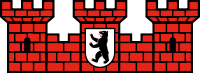
All the coats of arms of Berliner boroughs (the current as the ones in the period 1990-2001) have some common points: The shield has a Spanish form and the coronet is represented by a mural crown: 3 towers in red bricks with the coat of arms of Berlin in the middle.
Most of the coats of arms of current boroughs [2] have changed some elements in their field: Some of them have created a "fusion" of themes of the merged Bezirke (Charlottenburg-Wilmersdorf, Lichtenberg, Steglitz-Zehlendorf, Tempelhof-Schöneberg); others have modified their themes taken from one of the two (or more) former merged boroughs (Friedrichshain-Kreuzberg, Marzahn-Hellersdorf, Mitte and Treptow-Köpenick). Only the unchanged boroughs of Neukölln, Reinickendorf and Spandau haven't changed their field. The coat of arms of Pankow was created with a new design in 2008, having been the only district without an emblem for 7 years.
 Charlottenburg-Wilmersdorf |
 Friedrichshain-Kreuzberg |
 Lichtenberg |
 Marzahn-Hellersdorf |
 Mitte |
 Neukölln |
 Pankow |
 Reinickendorf |
 Spandau |
 Steglitz-Zehlendorf |
 Tempelhof-Schöneberg |
 Treptow-Köpenick |
Localities
As of 2012, the twelve boroughs are made up of a total of 96 officially recognized localities (Ortsteile). Almost all of them are further subdivided into several other zones (defined in German as Ortslagen, Teile, Stadtviertel, Orte etc.). The largest Ortsteil is Köpenick (34.9 km2 or 13.5 sq mi), the smallest one is Hansaviertel (53 ha or 130 acres). The most populated is Neukölln (154,127 inhabitants in 2009), the least populated is Malchow (450 inhabitants in 2008).[3]
- (01) Mitte
| Locality | Area in km² |
Population as of 2008 |
Density inhabitants per km² |
Map |
|---|---|---|---|---|
| 10.70 | 79,582 | 7,445 | 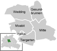 | |
| 7.72 | 69,425 | 8,993 | ||
| 0.53 | 5,889 | 11,111 | ||
| 5.17 | 12,486 | 2,415 | ||
| 9.23 | 76,363 | 8,273 | ||
| 6.13 | 82,729 | 13,496 |
| Locality | Area in km² |
Population as of 2008 |
Density inhabitants per km² |
Map |
|---|---|---|---|---|
| 9.78 | 114,050 | 11,662 | 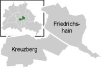 | |
| 10.40 | 147,227 | 14,184 |
- (03) Pankow
| Locality | Area in km² |
Population as of 2008 |
Density inhabitants per km² |
Map |
|---|---|---|---|---|
| 11.00 | 142,319 | 12,991 |  | |
| 7.93 | 45,485 | 5,736 | ||
| 6.03 | 6,550 | 1,086 | ||
| 3.95 | 6,580 | 1,666 | ||
| 6.65 | 18,258 | 2,746 | ||
| 5.68 | 1,166 | 205 | ||
| 5.66 | 55,854 | 9,868 | ||
| 13.40 | 1,917 | 144 | ||
| 18.20 | 13,188 | 727 | ||
| 12.00 | 18,766 | 1,560 | ||
| 6.49 | 26,903 | 4,145 | ||
| 4.90 | 8,933 | 1,823 | ||
| 1.37 | 7,216 | 5,267 |
| Locality | Area in km² |
Population as of 2008 |
Density inhabitants per km² |
Map |
|---|---|---|---|---|
| 10.60 | 118,704 | 11,198 |  | |
| 7.16 | 92,815 | 12,963 | ||
| 3.59 | 19,750 | 5,501 | ||
| 22.30 | 10,014 | 448 | ||
| 13.50 | 37,883 | 2,800 | ||
| 6.20 | 17,327 | 2,795 | ||
| 1.27 | 13,966 | 10,997 |
- (05) Spandau
| Locality | Area in km² |
Population as of 2008 |
Density inhabitants per km² |
Map |
|---|---|---|---|---|
| 8.03 | 33,433 | 4,164 |  | |
| 4.73 | 13,668 | 2,891 | ||
| 5.66 | 11,388 | 2,012 | ||
| 10.90 | 41,470 | 3,810 | ||
| 10.10 | 3,908 | 386 | ||
| 14.80 | 13,628 | 922 | ||
| 20.40 | 26,337 | 1,292 | ||
| 6.88 | 34,778 | 5,056 | ||
| 10.40 | 37,080 | 3,558 |
- (06) Steglitz-Zehlendorf
| Locality | Area in km² |
Population as of 2008 |
Density inhabitants per km² |
Map |
|---|---|---|---|---|
| 6.79 | 70,555 | 10,391 |  | |
| 18.20 | 78,338 | 4,300 | ||
| 6.99 | 40,385 | 5,778 | ||
| 18.80 | 57,902 | 3,075 | ||
| 8.39 | 14,966 | 1,784 | ||
| 19.60 | 15,899 | 811 | ||
| 23.70 | 9,044 | 382 |
- (07) Tempelhof-Schöneberg
| Locality | Area in km² |
Population as of 2008 |
Density inhabitants per km² |
Map |
|---|---|---|---|---|
| 10.60 | 116,743 | 11,003 | 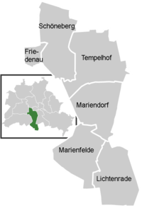 | |
| 1.65 | 26,736 | 16,204 | ||
| 12.20 | 54,382 | 4,458 | ||
| 9.38 | 48,882 | 5,211 | ||
| 9.15 | 30,151 | 3,295 | ||
| 10.10 | 49,451 | 4,896 |
- (08) Neukölln
| Locality | Area in km² |
Population as of 2008 |
Density inhabitants per km² |
Map |
|---|---|---|---|---|
| 11.70 | 154,127 | 13,173 | 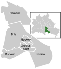 | |
| 12.40 | 38,334 | 3,091 | ||
| 6.35 | 38,018 | 5,987 | ||
| 11.80 | 41,040 | 3,478 | ||
| 2.66 | 35,844 | 13,475 |
- (09) Treptow-Köpenick
| Locality | Area in km² |
Population as of 2008 |
Density inhabitants per km² |
Map |
|---|---|---|---|---|
| 2.31 | 10,426 | 4,513 |  | |
| 3.01 | 10,618 | 3,528 | ||
| 4.82 | 16,780 | 3,481 | ||
| 6.54 | 17,650 | 2,699 | ||
| 3.49 | 10,043 | 2,878 | ||
| 7.89 | 26,101 | 3,308 | ||
| 6.11 | 15,112 | 2,473 | ||
| 6.52 | 10,751 | 1,649 | ||
| 6.18 | 17,094 | 2,766 | ||
| 34.90 | 59,201 | 1,695 | ||
| 14.00 | 17,285 | 1,233 | ||
| 21.50 | 8,891 | 414 | ||
| 9.13 | 5,482 | 600 | ||
| 22.20 | 6,350 | 286 | ||
| 17.10 | 4,117 | 240 |
- (10) Marzahn-Hellersdorf
| Locality | Area in km² |
Population as of 2008 |
Density inhabitants per km² |
Map |
|---|---|---|---|---|
| 19.50 | 102,398 | 5,240 |  | |
| 12.40 | 24,543 | 1,973 | ||
| 8.81 | 18,732 | 2,126 | ||
| 12.90 | 26,852 | 2,075 | ||
| 8.10 | 72,602 | 8,963 |
- (11) Lichtenberg
| Locality | Area in km² |
Population as of 2008 |
Density inhabitants per km² |
Map |
|---|---|---|---|---|
| 5.55 | 50,010 | 9,011 | 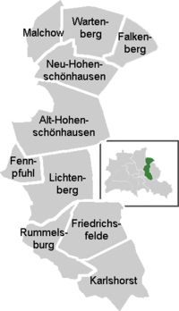 | |
| 6.60 | 21,329 | 3,232 | ||
| 7.22 | 32,295 | 4,473 | ||
| 3.06 | 1,164 | 380 | ||
| 1.54 | 450 | 292 | ||
| 6.92 | 2,433 | 352 | ||
| 5.16 | 53,698 | 10,407 | ||
| 9.33 | 41,780 | 4,478 | ||
| 2.12 | 30,932 | 14,591 | ||
| 4.52 | 17,567 | 3,887 |
- Codes 1105 and 1108 (this one to former Hohenschönhausen locality) are not assigned
- (12) Reinickendorf
| Locality | Area in km² |
Population as of 2008 |
Density inhabitants per km² |
Map |
|---|---|---|---|---|
| 10.50 | 72,859 | 6,939 |  | |
| 33.70 | 33,417 | 992 | ||
| 2.20 | 5,997 | 2,726 | ||
| 10.70 | 17,641 | 1,649 | ||
| 7.80 | 17,025 | 2,183 | ||
| 6.10 | 16,503 | 2,705 | ||
| 2.30 | 10,022 | 4,357 | ||
| 5.00 | 4,915 | 983 | ||
| 5.87 | 22,696 | 3,866 | ||
| 3.20 | 35,206 | 11,002 | ||
| 2.03 | 6,432 | 3,168 |
See also
![]() Boroughs of Berlin – Wikipedia book
Boroughs of Berlin – Wikipedia book
References
- ↑ (German) Boroughs, Localities, and Statistical Tracts from Berlin's Statistical Office Archived January 27, 2006, at the Wayback Machine.
- ↑ (German) Coats of arms of Berliner boroughs on www.berlin.de Archived April 14, 2010, at the Wayback Machine.
- ↑ (German) Statistics for Berliner Ortsteile
External links
 Media related to Boroughs of Berlin at Wikimedia Commons
- Media related to Localities of Berlin at Wikimedia Commons
| |
| West boroughs (1920–2000) | | |
|---|---|---|
| East boroughs (1920–2000) |
| |
| Administration |
| |
|---|---|---|
| Society | ||
| Other topics | ||
| ||