Boredale Hause
Coordinates: 54°34′55″N 2°46′08″W / 54.582°N 2.769°W
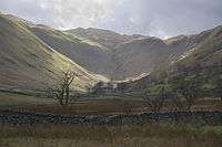
Viewed from Boredale
Boredale Hause is a mountain pass between Place Fell and Angletarn Pikes in the east of the English Lake District.[1][2] It links the Patterdale and Boredale valleys. There is a large confusion of paths on the hause, which is largely grassy.
See also
References
- ↑ Ordnance Survey: Landranger map sheet 90 Penrith & Keswick (Ambleside) (Map). Ordnance Survey. 2011. ISBN 9780319232064.
- ↑ "Ordnance Survey: 1:50,000 Scale Gazetteer" (csv (download)). www.ordnancesurvey.co.uk. Ordnance Survey. 1 January 2016. Retrieved 30 January 2016.
This article is issued from Wikipedia - version of the 5/20/2016. The text is available under the Creative Commons Attribution/Share Alike but additional terms may apply for the media files.