Bora Bora
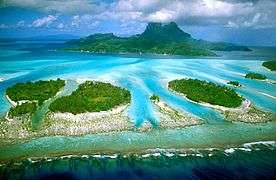
 NASA picture of the island of Bora Bora and its lagoon | |
 | |
| Geography | |
|---|---|
| Location | Pacific Ocean |
| Archipelago | Society Islands |
| Area | 29.3 km2 (11.3 sq mi) |
| Highest elevation | 727 m (2,385 ft) |
| Highest point | Mount Otemanu |
| Administration | |
|
France | |
| Overseas collectivity | French Polynesia |
| Administrative subdivision | Leeward Islands |
| Commune | Bora-Bora |
| Largest settlement | Vaitape (pop. 4,927 inhabitants) |
| Demographics | |
| Population | 8,880[1] (August 2007 census) |
| Pop. density | 300 /km2 (800 /sq mi) |
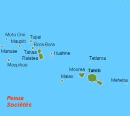
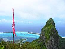
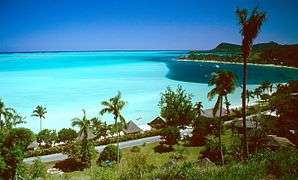
Bora Bora is a 29.3 km2 (11 sq mi) island in the Leeward group in the western part of the Society Islands of French Polynesia, an overseas collectivity of France in the Pacific Ocean. The island, located about 230 kilometres (143 miles) northwest of Papeete, is surrounded by a lagoon and a barrier reef. In the centre of the island are the remnants of an extinct volcano rising to two peaks, Mount Pahia and Mount Otemanu, the highest point at 727 metres (2,385 feet).
Bora Bora is a major international tourist destination, famous for its aqua-centric luxury resorts. The major settlement, Vaitape, is on the western side of the main island, opposite the main channel into the lagoon. Produce of the island is mostly limited to what can be obtained from the sea and the plentiful coconut trees, which were historically of economic importance for copra. According to a 2008 census, Bora Bora has a permanent population of 8,880.
Name
In ancient times the island was called "Pora pora mai te pora", meaning "created by the gods" in the local Tahitian dialect. This was often abbreviated Pora Pora meaning simply first born. Because of ambiguities in the phonemes of the Tahitian language, this could also be pronounced Bola Bola or Bora Bora.[2] When explorer Jakob Roggeveen first landed on the island, he and his crew adopted the name Bora Bora which has stood ever since.[3]
History
The island was inhabited by Polynesian settlers around the 4th century C.E. The first European sighting was made by Jakob Roggeveen in 1722. James Cook sighted the island in 1770 and landed that same year. The London Missionary Society arrived in 1820 and founded a Protestant church in 1890. Bora Bora was an independent kingdom until 1888 when its last queen Teriimaevarua III was forced to abdicate by the French who annexed the island as a colony.
-
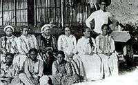
Queen Teriimaevarua III and her maids of honor, c. 1899
World War II
In World War II the United States chose Bora Bora as a South Pacific military supply base, and an oil depot, airstrip, seaplane base, and defensive fortifications were constructed. Known as "Operation Bobcat", it maintained a supply force of nine ships, 20,000 tons of equipment and nearly 7,000 men. Seven artillery guns were set up at strategic points around the island to protect it against potential military attack.
However, the island saw no combat as the American presence on Bora Bora went uncontested over the course of the war. The base was officially closed on June 2, 1946. The World War II airstrip, which was never able to accommodate large aircraft, was French Polynesia's only international airport until Faa'a International Airport was opened in Papeete, Tahiti, in 1960.[4]
Commune of Bora-Bora
| Bora-Bora | |
|---|---|
 Location of the commune (in red) within the Leeward Islands | |
| Coordinates: 16°29′40″S 151°44′11″W / 16.4944°S 151.7364°WCoordinates: 16°29′40″S 151°44′11″W / 16.4944°S 151.7364°W | |
| Country | France |
| Overseas collectivity | French Polynesia |
| Government | |
| • Mayor | Gaston Tong Sang |
| Area | 40.3 km2 (15.6 sq mi) |
| Population (August 2007 census)1 | 8,927 |
| • Density | 220/km2 (570/sq mi) |
| INSEE/Postal code | 98714 / 98730 |
| Elevation | 0–727 m (0–2,385 ft) |
| 1 Population without double counting: residents of multiple communes (e.g., students and military personnel) only counted once. | |
The commune of Bora-Bora is made up of the island of Bora Bora proper with its surrounding islets emerging from the coral reef, 29.3 km2 (11.3 sq mi) in total, and of the atoll of Tupai (11 km2 or 4.2 sq mi), located 20 kilometres (12 mi) north of Bora Bora. The atoll of Tupai has no permanent population apart from about 50 workers in the coconut plantations.
The surrounding islets include: Motu Tapu, Motu Ahuna, Tevairoa, Motu Tane, Motu Mute, Motu Tufari, Motu Tehotu, Motu Pitiaau, Sofitel Motu, Motu Toopua, and Toopuaiti.
Administration
The commune is in the administrative subdivision of the Leeward Islands and consists of the following associated communes:
- Anau
- Faanui
- Vaitape
The administrative centre of the commune is the settlement of Vaitape, on the island of Bora Bora. The island is administratively part of the commune (municipality) of Bora-Bora, itself in the administrative subdivision of the Leeward Islands. President of French Polynesia Édouard Fritch is the current mayor of Bora Bora in addition to being the President.[5]
Tourism

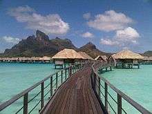
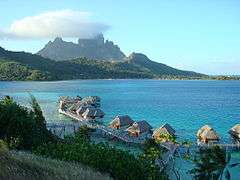
Today the island's economy is driven almost solely by tourism. Over the last few years several resorts have been built on motu (small islands, from Tahitian) surrounding the lagoon. Hotel Bora Bora opened in 1961, and nine years later built the first over-the-water bungalows on stilts over the lagoon.[6] Today, over-water bungalows are a standard feature of most Bora Bora resorts. The quality of those bungalows ranges from comparably cheap, basic accommodations to very luxurious and expensive places to stay.
Most of the tourist destinations are aqua-centric; however it is possible to visit attractions on land such as WWII cannons. Air Tahiti has five or six flights daily to the Bora Bora Airport on Motu Mute from Tahiti (as well as from other islands). The island is served by Bora Bora Airport on Motu Mute in the north, with Air Tahiti providing daily flights to and from Papeete on Tahiti.
Public transport on the island is nonexistent. Rental cars and bicycles are the recommended methods of transport. There are also small, two-seater buggies for hire in Vaitape. It is possible to rent a motorboat to explore the lagoon.
Snorkeling and scuba diving in and around the lagoon of Bora Bora are popular activities. Many species of sharks and rays inhabit the surrounding body of water. There are a few dive operators on the island offering manta ray dives and also shark-feeding dives.
In addition to the existing islands of Bora Bora, the new manmade motu of Motu Marfo has been added in the northeastern corner of the lagoon on the property of the St. Regis Resort.[7]

Climate
| Climate data for Bora-Bora | |||||||||||||
|---|---|---|---|---|---|---|---|---|---|---|---|---|---|
| Month | Jan | Feb | Mar | Apr | May | Jun | Jul | Aug | Sep | Oct | Nov | Dec | Year |
| Average high °C (°F) | 30.2 (86.4) |
30.8 (87.4) |
30.5 (86.9) |
30.3 (86.5) |
29.5 (85.1) |
28.6 (83.5) |
28.1 (82.6) |
28.1 (82.6) |
28.6 (83.5) |
29.1 (84.4) |
29.4 (84.9) |
29.6 (85.3) |
29.3 (84.7) |
| Average low °C (°F) | 25.1 (77.2) |
25.3 (77.5) |
25.5 (77.9) |
25.5 (77.9) |
25.1 (77.2) |
24.2 (75.6) |
23.8 (74.8) |
23.8 (74.8) |
24.0 (75.2) |
24.3 (75.7) |
24.6 (76.3) |
24.8 (76.6) |
24.7 (76.5) |
| Average rainfall mm (inches) | 268.7 (10.579) |
233.2 (9.181) |
176.9 (6.965) |
182.7 (7.193) |
129.8 (5.11) |
98.2 (3.866) |
83.3 (3.28) |
59.7 (2.35) |
65.5 (2.579) |
99.8 (3.929) |
203.7 (8.02) |
280.6 (11.047) |
1,882.1 (74.098) |
| Mean monthly sunshine hours | 201.1 | 202.6 | 239.4 | 219.8 | 224.1 | 224.5 | 231.8 | 248.4 | 241.0 | 230.5 | 217.7 | 207.0 | 2,687.9 |
| Source: NOAA[8] | |||||||||||||
Most rainfall occurs during the summer months (November to April) and is accompanied by high humidity, although clear days are not unknown in mid-January.
Gallery
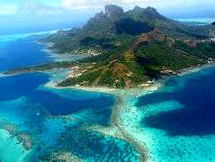
-
Aerial view of Bora Bora
-
Aerial view of Bora Bora
-
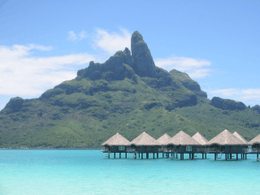
Mount Otemanu
-
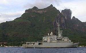
The French frigate Floréal, stationed in Bora-Bora lagoon
-
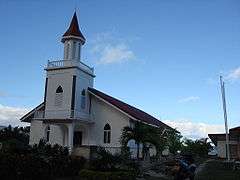
Maohi Protestant Church in Anau
-
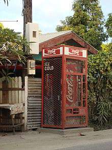
Coca-Cola Machine in Vaitape
-
-
Bora Bora
-

Bora Bora
-
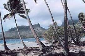
Matira Beach and Lagoon
-

Looking east toward Marara Beach Motu in Bora Bora - 3 July 2012
-

Flag of Bora Bora
-
Sofitel Motu with Mount Otemanu in the background - 26 October 2007
See also
References
- ↑ Population of the commune of Bora-Bora minus about 50 workers living in the coconut plantations on the atoll of Tupai.
- ↑ Garanger, Jose; Robineau, Claude (1970). Bora-Bora: English Version. Nouvelles Editions Latines. p. 11.
- ↑ Woods, Michael; Woods, Mary B. (2009). Seven Natural Wonders of Australia and Oceania. Twenty-First Century Books. p. 58. ISBN 978-0822590743.
- ↑ "Our History". Our History. Office of Post and Telecommunications. Retrieved 18 April 2011.
- ↑ "President of French Polynesia steps down". The Australian. 8 February 2009. Retrieved 12 February 2009.
- ↑ "Complete Reconstruction Scheduled for Hotel Bora Bora". Retrieved 2015-02-15.
- ↑ "The St. Regis Bora Bora Resort". boraboraallinclusiveguide.com. Retrieved 22 August 2014.
- ↑ "Bora-Bora Motu Climate Normals 1961–1990". National Oceanic and Atmospheric Administration. Retrieved May 12, 2013.