Bonnet Carré Crevasse

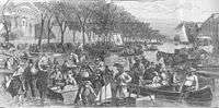
The Bonnet Carré Crevasse was one of several levee breaches in the Bonnet Carré area in the mid-to-late-1800s.[1] Bonnet Carré was approximately 50 kilometers from New Orleans, Louisiana.[2]
The breach occurred when excess water from the Mississippi River flowed over the east bank levee of Bonnet Carré.[1] The original levee was over 12 feet high, and the Crevasse itself spanned about 1200 feet.[2] Local drainage systems were unable to contain the floodwater.[1] The water rushed at 8 miles per hour, causing the width of the breach to increase by the day.[2] Strong northern winds caused the excess water to enter Lake Pontchartrain and surrounding urban areas, including neighborhoods Metairie and Gentilly.[1] The increasing force of the flood also caused another nearby levee to break.[1]
Although the devastation to the Bonnet Carré area was great, its ecological impacts were somewhat beneficial.[3] By diverting river water and sediment, the crevasse saved a greater portion of land surrounding the area from succumbing to total flooding and land erosion.[3] Therefore, the crevasse served as a buffer for wetland erosion. Recognizing the benefits, the local government commissioned the construction of an artificial crevasse that could be periodically opened to drain excess water from the Mississippi.[3]
The river levee was not restored at Bonnet Carré until 1883.[4]
The area is now the site of the Bonnet Carré Spillway.[4]
| Wikimedia Commons has media related to Bonnet Carré Crevasse. |
References
- 1 2 3 4 5 Rogers, J.D. (May 2008). "Development of the New Orleans Flood Protection System prior to Hurricane Katrina" (PDF). Journal of Geotechnical and Geoenvironmental Engineering. doi:10.1061/(ASCE)1090-0241(2008)134:5(602). Retrieved 25 October 2015.
- 1 2 3 "The Bonnet Carre Crevasse". Old News. Ann Arbor District Library. 19 May 1871. Retrieved 25 October 2015.
- 1 2 3 Kesel, Richard H. (1989-05-01). "The role of the Mississippi River in wetland loss in southeastern Louisiana, U.S.A.". Environmental Geology and Water Sciences. 13 (3): 183–193. Bibcode:1989EnGeo..13..183K. doi:10.1007/BF01665368. ISSN 0099-0094.
- 1 2 "Bonnet Carré Crevasse Historical Marker". StoppingPoints.com. StoppingPoints.com. 27 July 2007. Retrieved 25 October 2015.