Boney Peak
| Boney Peak | |
|---|---|
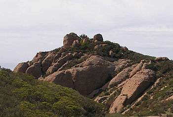 The peak viewed from the trail to the northeast. | |
| Highest point | |
| Elevation | 2828+ ft (862+ m) NAVD 88[1] |
| Listing | Sierra Club LPC[2] |
| Coordinates | 34°06′59″N 118°56′26″W / 34.116281°N 118.940434°WCoordinates: 34°06′59″N 118°56′26″W / 34.116281°N 118.940434°W [3] |
| Geography | |
| Location | Ventura County, California, U.S. |
| Parent range | Santa Monica Mountains |
| Topo map | USGS Triunfo Pass |
Boney Peak is a peak of the sandstone Boney Mountain formation, in Circle X Ranch Park of the Santa Monica Mountains National Recreation Area in Southern California.[4] It is one of the highest points in the Santa Monica Mountains, and is in Ventura County.
Hiking trails reach Boney Mountain and Peak, and feature views of the Pacific Ocean, Channel Islands, and Mount Baldy. Several lead to a waterfall unofficially called Sycamore Canyon Waterfall.
The Boney Mountain Wilderness area is in the adjacent Point Mugu State Park.
See also
References
- ↑ "Boney Peak". Peakbagger.com. Retrieved 2009-12-17.
- ↑ "Lower Peaks Committee List". Angeles Chapter, Sierra Club. Retrieved 2009-12-17.
- ↑ "Boney Peak". Geographic Names Information System. United States Geological Survey. Retrieved 2010-05-19.
- ↑ "Circle X Ranch" (PDF). Santa Monica Mountains National Recreation Area, National Park Service. Archived from the original (PDF) on 2009-06-01. Retrieved 2008-12-17.
External links
| Wikimedia Commons has media related to Circle X Ranch Park. |
- Santa Monica Mountains National Recreation Area: Circle X Ranch Park trail website
- NPS: Santa Monica Mountains National Recreation Area website
This article is issued from Wikipedia - version of the 11/5/2016. The text is available under the Creative Commons Attribution/Share Alike but additional terms may apply for the media files.