Gulf of Boni
| Gulf of Boni | |
|---|---|
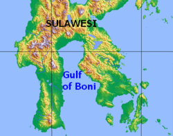 Map of the Gulf of Boni | |
| Location | Sulawesi |
| Coordinates | 4°0′S 120°45′E / 4.000°S 120.750°ECoordinates: 4°0′S 120°45′E / 4.000°S 120.750°E |
| Basin countries | Indonesia |
The Gulf of Boni[1] (Indonesian: Teluk Boni), also known as the Bay of Boni, Bone Bay, and the Bone Gulf, is the gulf which divides the South and Southeast Peninsulas of the island of Sulawesi (Celebes) in Indonesia. It opens on the south into the Banda Sea.
Extent
The International Hydrographic Organization (IHO) defines the Gulf of Boni as being one of the divisions of the East Indian Archipelago.[2] It is defined as the waters north of the "line from Tg. Lassa, Celebes, to the North point of Kabaena (5°05′S 121°52′E / 5.083°S 121.867°E) and thence up this meridian to the coast of Celebes."[1]
See also
References
Citations
- 1 2 IHO (1953), §48 (k).
- ↑ IHO (1953), §48.
Bibliography
This article is issued from Wikipedia - version of the 10/6/2015. The text is available under the Creative Commons Attribution/Share Alike but additional terms may apply for the media files.