Bokel, Lower Saxony
| Bokel | ||
|---|---|---|
| Ortsteil of Beverstedt | ||
| ||
 Bokel | ||
Bokel in Beverstedt 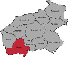
 | ||
| Coordinates: 53°23′N 08°46′E / 53.383°N 8.767°ECoordinates: 53°23′N 08°46′E / 53.383°N 8.767°E | ||
| Country | Germany | |
| State | Lower Saxony | |
| District | Cuxhaven | |
| Municipality | Beverstedt | |
| Area | ||
| • Total | 20.96 km2 (8.09 sq mi) | |
| Population (2010-12-31) | ||
| • Total | 2,511 | |
| • Density | 120/km2 (310/sq mi) | |
| Time zone | CET/CEST (UTC+1/+2) | |
| Postal codes | 27616 | |
| Dialling codes | 04748 | |
| Vehicle registration | CUX | |
| Website | www.beverstedt.de | |

Bokel is a village and a former municipality in the district of Cuxhaven, in Lower Saxony, Germany. Since 1 November 2011, it is part of the municipality Beverstedt.
Bokel belonged to the Prince-Archbishopric of Bremen, established in 1180. In 1648 the Prince-Archbishopric was transformed into the Duchy of Bremen, which was first ruled in personal union by the Swedish Crown - interrupted by a Danish occupation (1712–1715) - and from 1715 on by the Hanoverian Crown. The Kingdom of Hanover incorporated the Duchy in a real union and the Ducal territory, including Bokel, became part of the new Stade Region, established in 1823.
References
| Wikimedia Commons has media related to Bokel, Lower Saxony. |
This article is issued from Wikipedia - version of the 10/14/2016. The text is available under the Creative Commons Attribution/Share Alike but additional terms may apply for the media files.