Bojana (river)
| Bojana / Buna (Бојана / Bunë) | |
| River | |
 | |
| Countries | Albania, Montenegro |
|---|---|
| Municipality | Shkodër, Ulcinj |
| Tributaries | |
| - left | Great Drin |
| City | Shkodra |
| Source | Lake Skadar |
| Mouth | Adriatic Sea |
| - coordinates | 41°50′50″N 19°22′18″E / 41.84722°N 19.37167°ECoordinates: 41°50′50″N 19°22′18″E / 41.84722°N 19.37167°E |
| Length | 41 km (25 mi) |
The Bojana or Buna (Albanian: Bunë or Buna; Montenegrin and Serbian: Бојана, Bojana) is a 41 km long river in Albania and Montenegro which flows both into the Adriatic Sea. An outflow of Lake Skadar, measured from the source of the lake's longest tributary, the Morača, the Morača-Lake Skadar- Bojana system is 183 km long.
Course
The river in Albania
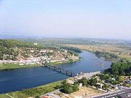
The river used to be longer, but due to a rise in the level of Lake Skadar, the uppermost part of the river is now under the lake's surface. The river initially flows east, but after only few kilometers reaches the city of Shkodër and turns to the south. On the southern outskirts of the city, the river receives its most important tributary, the Great Drin, the greater part of which became its tributary after changing course during a flood in 1858 and now brings ten times more water than the Bojana itself (320 m³/s). After flowing around the Peak of Tarabosh, it passes through the villages of Zues, Bërdicë, Darragjat, Oblikë, Obot, Shirq, Dajç and Goricë.
Border river and the mouth
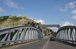
After 20 kilometers in Albania, it forms the border between Albania and Montenegro. On this border section, which is 24 km long, the river meanders widely, flowing around Lakes Šas and Zogajsko blato, both in Montenegro. Settlements include villages of Sveti Đorđe and Reč on the Montenegrin, and Luarzë and Pulaj on the Albanian side. The area surrounding the river in this section is low and marshy, the Buna being the eastern border of the Field of Ulcinj and of the 12 km-long Long beach (Velika Plaža) of Ulcinj.
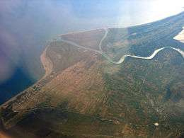
At its mouth into the Adriatic the Buna forms a small delta with two arms, the left one forming the border with Albania, and the right one, with the island between the arms, being part of Montenegro. The island is called Ada Bojana -Ada, the Turkish word for "island", has found its way into the Montenegrin language. It was supposedly formed around a ship's wreck in the 19th century, and now covers an area of 6 km2, and is Montenegro's largest island. With the neighboring resort of Sveti Nikola ("Saint Nicholas"), it is a major center of nudism along the Adriatic.
The other, smaller island belongs to Albania and is called Franc Jozeph Island or 'Ada Major'. This small island is not artificial such as Ada Bojana but natural. The Island of Franz Joseph frequently receives tourists.
Characteristics
Despite being short, the river has quite a large watershed, covering 5,187 km², because the whole drainage area of Lake Skadar, the largest lake in southeastern Europe, is also part of it. Also, thanks to the waters from the Great Drin, the Bojana / Buna ranks second place among all tributaries to the Adriatic, measured by the annual discharge, after the Po in Italy (with 352 m³/s).
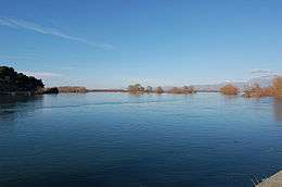
The Bojana / Buna is navigable throughout its whole course, depending on the size of your boat.
References
| Wikimedia Commons has media related to River Buna. |
- Mala Prosvetina Enciklopedija, Third edition, Prosveta, 1985, ISBN 86-07-00001-2
- Jovan Đ. Marković, Enciklopedijski geografski leksikon Jugoslavije, Svjetlost-Sarajevo, 1990, ISBN 86-01-02651-6
Albania's hydrographic network consists of 8 major rivers that form over 152 river streams and connecting waterways. | |
| Town |  | ||||||||||||||
|---|---|---|---|---|---|---|---|---|---|---|---|---|---|---|---|
| Villages | |||||||||||||||
| Geography |
| ||||||||||||||
| Landmarks |
| ||||||||||||||
| Hotels | |||||||||||||||
| Sports clubs | |||||||||||||||
| Sports grounds | |||||||||||||||
| Events | |||||||||||||||
| Television | |||||||||||||||