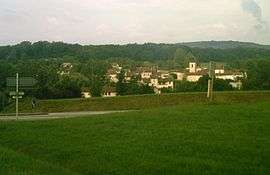
Bohas-Meyriat-Rignat
| Bohas-Meyriat-Rignat | |
|---|---|
 | |
 Bohas-Meyriat-Rignat | |
|
Location within Auvergne-Rhône-Alpes region  Bohas-Meyriat-Rignat | |
| Coordinates: 46°08′14″N 5°23′28″E / 46.1372°N 5.3911°ECoordinates: 46°08′14″N 5°23′28″E / 46.1372°N 5.3911°E | |
| Country | France |
| Region | Auvergne-Rhône-Alpes |
| Department | Ain |
| Arrondissement | Bourg-en-Bresse |
| Canton | Ceyzériat |
| Intercommunality | La Vallière |
| Government | |
| • Mayor (2008–2014) | Jean-Luc Luez |
| Area1 | 23.51 km2 (9.08 sq mi) |
| Population (2008)2 | 815 |
| • Density | 35/km2 (90/sq mi) |
| Time zone | CET (UTC+1) |
| • Summer (DST) | CEST (UTC+2) |
| INSEE/Postal code | 01245 / 01250 |
| Elevation |
264–555 m (866–1,821 ft) (avg. 420 m or 1,380 ft) |
|
1 French Land Register data, which excludes lakes, ponds, glaciers > 1 km² (0.386 sq mi or 247 acres) and river estuaries. 2 Population without double counting: residents of multiple communes (e.g., students and military personnel) only counted once. | |
Bohas-Meyriat-Rignat is a commune in the Ain department in eastern France.
History
The commune was created in January 1974 as a grouping of the three villages Bohas, Meyriat, and Rignat.
Population
| Historical population | ||
|---|---|---|
| Year | Pop. | ±% |
| 1793 | 667 | — |
| 1800 | 733 | +9.9% |
| 1806 | 603 | −17.7% |
| 1821 | 666 | +10.4% |
| 1831 | 677 | +1.7% |
| 1836 | 620 | −8.4% |
| 1841 | 602 | −2.9% |
| 1846 | 567 | −5.8% |
| 1851 | 593 | +4.6% |
| 1856 | 568 | −4.2% |
| 1861 | 570 | +0.4% |
| 1866 | 559 | −1.9% |
| 1872 | 529 | −5.4% |
| 1876 | 500 | −5.5% |
| 1881 | 460 | −8.0% |
| 1886 | 450 | −2.2% |
| 1891 | 459 | +2.0% |
| 1896 | 395 | −13.9% |
| 1901 | 392 | −0.8% |
| 1906 | 361 | −7.9% |
| 1911 | 342 | −5.3% |
| 1921 | 311 | −9.1% |
| 1926 | 304 | −2.3% |
| 1931 | 299 | −1.6% |
| 1936 | 301 | +0.7% |
| 1946 | 246 | −18.3% |
| 1954 | 243 | −1.2% |
| 1962 | 219 | −9.9% |
| 1968 | 186 | −15.1% |
| 1975 | 506 | +172.0% |
| 1982 | 597 | +18.0% |
| 1990 | 657 | +10.1% |
| 1999 | 727 | +10.7% |
| 2008 | 815 | +12.1% |
See also
References
| Wikimedia Commons has media related to Bohas-Meyriat-Rignat. |
This article is issued from Wikipedia - version of the 10/27/2016. The text is available under the Creative Commons Attribution/Share Alike but additional terms may apply for the media files.