Bogniebrae

Coordinates: 57°29′N 2°41′W / 57.49°N 02.68°W
Bogniebrae is a rural settlement in Aberdeenshire, Scotland.[1][2]
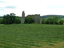
Remains of Conzie or Bognie Castle, near Bogniebrae, built in the 1660s
References
- ↑ Ordnance Survey: Landranger map sheet 29 Banff & Huntly (Portsoy & Turriff) (Map). Ordnance Survey. 2014. ISBN 9780319231043.
- ↑ "Ordnance Survey: 1:50,000 Scale Gazetteer" (csv (download)). www.ordnancesurvey.co.uk. Ordnance Survey. 1 January 2016. Retrieved 30 January 2016.
| Wikimedia Commons has media related to Bogniebrae. |
Settlements and places of interest in Marr, Aberdeenshire | ||
|---|---|---|
| Primary settlements |  | |
| Other settlements | ||
| Places of interest |
| |
Areas and primary settlements in Aberdeenshire (see also: Aberdeen City) | ||
|---|---|---|
| in Banff and Buchan |  | |
| in Buchan | ||
| in Formartine | ||
| in Garioch | ||
| in Kincardine and Mearns | ||
| in Marr | ||
This article is issued from Wikipedia - version of the 10/20/2016. The text is available under the Creative Commons Attribution/Share Alike but additional terms may apply for the media files.