Bluestone Lake
| Bluestone Lake | |
| Reservoir | |
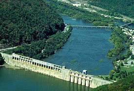 Bluestone Dam | |
| Country | United States |
|---|---|
| States | Virginia, West Virginia |
| Counties | Giles VA, Mercer WV, Monroe WV, Summers WV |
| Elevation | 1,421 ft (433.1 m) [1] |
| Coordinates | 37°38′25″N 80°53′09″W / 37.64028°N 80.88583°WCoordinates: 37°38′25″N 80°53′09″W / 37.64028°N 80.88583°W [1] |
| Source | New River |
| Secondary source | Bluestone River |
| Length | 10.7 mi (17 km) [2] |
| Basin | 4,565 sq mi (11,823 km2) [2] |
| Area | 2,040 acres (825.6 ha) [2] |
| Completed | January 1952 [2] |
| - Operational | January 1949 [2] |
| Owner | U.S. Army Corps of Engineers, Huntington District |
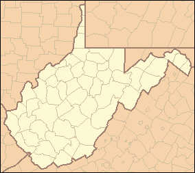 Location of Bluestone Lake in West Virginia
| |
Bluestone Lake is a flood control reservoir located on the New River near Hinton, West Virginia. At its normal pool level, Bluestone Dam impounds a 10.7-mile (17.2 km) stretch of the New and its tributary, the Bluestone River. Normally approximately 2,040 acres (8.3 km2) in size, the lake can grow to over 36 miles (58 km) long at flood control pool. At higher water levels, the lake extends into Giles County, Virginia.[3]
Bluestone Dam
The lake is formed by Bluestone Dam, a concrete gravity dam located just upstream of the confluence of the New and Greenbrier Rivers. The dam is 165 feet (50 m) high and 2,048 feet (624 m) long.[2] The dam was authorized by Presidential Executive Order in 1935 and approved by the U.S. Congress in the Flood Control Acts of 1936 and 1938.[4] Construction of the project was begun in early 1941, suspended in 1944 because of World War II.[5] Work resumed in 1946, and completed for operational purposes in 1949.[2][6]
In recent years, it was discovered that Bluestone Dam would be unable to pass the Probable Maximum Flood possible at the site, which could cause failure of the dam. To remedy the problem, the U.S. Army Corps of Engineers has undertaken a Dam Safety Assurance program for Bluestone. The DSA project includes raising the dam by 8 feet (2.4 m), installing anchors and thrust blocks to tie the dam into bedrock, spillway improvements and other work. The first phase of the project was completed in October 2004. The second phase, installing bedrock anchors, is underway as of March 2010 and expected to be finished in 2011. Three additional phases remain to be constructed.[4]
Recreation
Due to its large size, Bluestone Lake provides many recreational opportunities including boating and fishing.[2] The West Virginia Division of Natural Resources operates Bluestone State Park and Bluestone Wildlife Management Area, each encompassing portions of the lake.[7] Camping and other activities are available in these facilities.[2]
See also
References
- 1 2 "Bluestone Lake". Geographic Names Information System. United States Geological Survey. June 27, 1980. Retrieved March 27, 2010.
- 1 2 3 4 5 6 7 8 9 "Bluestone Lake". U.S. Army Corps of Engineers, Huntington District. Retrieved March 27, 2010.
- ↑ Narrows, Virginia-West Virginia quadrangle (Map). 1:24,000. 7.5-Minute Series (Topographic). U.S. Geological Survey. 1985.
- 1 2 "Bluestone DSA". U.S. Army Corps of Engineers. Huntington District. Retrieved March 27, 2010.
- ↑ "Construction of Bluestone Dam: Phase I (1941–1944)". U.S. Army Corps of Engineers. Huntington District. Retrieved March 27, 2010.
- ↑ "Construction of Bluestone Dam: Phase II (1945–1949)". U.S. Army Corps of Engineers. Huntington District. Retrieved March 27, 2010.
- ↑ Bluestone Wildlife Management Area (PDF) (Map). West Virginia Division of Natural Resources. January 29, 2007. Retrieved March 27, 2010.