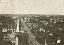
Blooming Prairie, Minnesota
| Blooming Prairie, Minnesota | |
|---|---|
| City | |
|
The Blooming Prairie Commercial Historic District is listed on the National Register of Historic Places. | |
 Location of Blooming Prairie within Steele and Dodge Counties in the state of Minnesota | |
| Coordinates: 43°52′2″N 93°3′17″W / 43.86722°N 93.05472°W | |
| Country | United States |
| State | Minnesota |
| Counties | Steele, Dodge |
| Area[1] | |
| • Total | 1.41 sq mi (3.65 km2) |
| • Land | 1.41 sq mi (3.65 km2) |
| • Water | 0 sq mi (0 km2) |
| Elevation | 1,293 ft (394 m) |
| Population (2010)[2] | |
| • Total | 1,996 |
| • Estimate (2012[3]) | 1,970 |
| • Density | 1,415.6/sq mi (546.6/km2) |
| Time zone | Central (CST) (UTC-6) |
| • Summer (DST) | CDT (UTC-5) |
| ZIP code | 55917 |
| Area code(s) | 507 |
| FIPS code | 27-06580[4] |
| GNIS feature ID | 0640277[5] |
| Website | www.bloomingprairie.com |


Blooming Prairie is a city in Dodge and Steele counties in the U.S. state of Minnesota. The population was 1,996 at the 2010 census.[6] Most of the city is located within Steele County; only a small part of the city extends into Dodge County.
History
Blooming Prairie was platted in 1868, taking the name of the surrounding Blooming Prairie Township, which was organized one year earlier.[7] A post office has been in operation at Blooming Prairie since 1868.[8] The city was incorporated by 1874.[9]
Geography
According to the United States Census Bureau, the city has a total area of 1.41 square miles (3.65 km2), all of it land.[1]
U.S. Highway 218 and Minnesota State Highway 30 are the main routes in the city.
Demographics
| Historical population | |||
|---|---|---|---|
| Census | Pop. | %± | |
| 1880 | 338 | — | |
| 1890 | 808 | 139.1% | |
| 1900 | 855 | 5.8% | |
| 1910 | 854 | −0.1% | |
| 1920 | 1,012 | 18.5% | |
| 1930 | 1,046 | 3.4% | |
| 1940 | 1,205 | 15.2% | |
| 1950 | 1,442 | 19.7% | |
| 1960 | 1,778 | 23.3% | |
| 1970 | 1,804 | 1.5% | |
| 1980 | 1,969 | 9.1% | |
| 1990 | 2,043 | 3.8% | |
| 2000 | 1,933 | −5.4% | |
| 2010 | 1,996 | 3.3% | |
| Est. 2015 | 1,993 | [10] | −0.2% |
2010 census
As of the census[2] of 2010, there were 1,996 people, 802 households, and 535 families residing in the city. The population density was 1,415.6 inhabitants per square mile (546.6/km2). There were 864 housing units at an average density of 612.8 per square mile (236.6/km2). The racial makeup of the city was 97.1% White, 0.4% African American, 0.3% Native American, 0.4% Asian, 0.6% from other races, and 1.3% from two or more races. Hispanic or Latino of any race were 6.3% of the population.
There were 802 households of which 32.2% had children under the age of 18 living with them, 52.9% were married couples living together, 9.6% had a female householder with no husband present, 4.2% had a male householder with no wife present, and 33.3% were non-families. 28.6% of all households were made up of individuals and 16.3% had someone living alone who was 65 years of age or older. The average household size was 2.42 and the average family size was 2.92.
The median age in the city was 40.5 years. 25.9% of residents were under the age of 18; 5.8% were between the ages of 18 and 24; 23.1% were from 25 to 44; 24.3% were from 45 to 64; and 21.2% were 65 years of age or older. The gender makeup of the city was 48.9% male and 51.1% female.
2000 census
As of the census[4] of 2000, there were 1,933 people, 748 households, and 504 families residing in the city. The population density was 1,428.4 people per square mile (552.8/km²). There were 774 housing units at an average density of 572.0 per square mile (221.4/km²). The racial makeup of the city was 96.43% White, 0.21% African American, 0.21% Native American, 0.36% Asian, 2.48% from other races, and 0.31% from two or more races. Hispanic or Latino of any race were 4.91% of the population.
Of the 748 households, 30.9% have children under the age of 18 living with them, 57.8% were married couples living together, 5.5% had a female householder with no husband present, and 32.5% were non-families. 28.2% of all households were made up of individuals and 16.6% had someone living alone who was 65 years of age or older. The average household size was 2.46 and the average family size was 3.02.
In the city the population was spread out with 25.7% under the age of 18, 7.5% from 18 to 24, 23.5% from 25 to 44, 20.2% from 45 to 64, and 23.0% who were 65 years of age or older. The median age was 40 years. For every 100 females there were 88.0 males. For every 100 females age 18 and over, there were 88.0 males.
The median income for a household in the city was $40,345, and the median income for a family was $51,118. Males had a median income of $34,911 versus $21,705 for females. The per capita income for the city was $19,343. About 2.8% of families and 6.6% of the population were below the poverty line, including 6.1% of those under age 18 and 9.8% of those age 65 or over.
Notable people
- Josh Braaten, actor, television's CSI: Miami, That 80's Show, Spin City, Married to the Kellys, among others, as well as several motion picture credits, including Dumb and Dumberer: When Harry Met Lloyd and Semi-Pro
References
- 1 2 "US Gazetteer files 2010". United States Census Bureau. Archived from the original on 2012-01-24. Retrieved 2012-11-13.
- 1 2 "American FactFinder". United States Census Bureau. Retrieved 2012-11-13.
- ↑ "Population Estimates". United States Census Bureau. Archived from the original on 2013-06-17. Retrieved 2013-05-28.
- 1 2 "American FactFinder". United States Census Bureau. Archived from the original on 2013-09-11. Retrieved 2008-01-31.
- ↑ "US Board on Geographic Names". United States Geological Survey. 2007-10-25. Retrieved 2008-01-31.
- ↑ "2010 Census Redistricting Data (Public Law 94-171) Summary File". American FactFinder. United States Census Bureau. Archived from the original on 21 July 2011. Retrieved 27 April 2011.
- ↑ Upham, Warren (1920). Minnesota Geographic Names: Their Origin and Historic Significance. Minnesota Historical Society. p. 532.
- ↑ "Steele County". Jim Forte Postal History. Retrieved 9 August 2015.
- ↑ "The History of Blooming Prairie". City of Blooming Prairie, MN. Retrieved 9 August 2015.
- ↑ "Annual Estimates of the Resident Population for Incorporated Places: April 1, 2010 to July 1, 2015". Retrieved July 2, 2016.
- ↑ "Census of Population and Housing". Census.gov. Archived from the original on May 11, 2015. Retrieved June 4, 2015.
External links
Municipalities and communities of Dodge County, Minnesota, United States | ||
|---|---|---|
| Cities |  | |
| Townships | ||
| Unincorporated communities | ||
| Ghost town | ||
| Footnotes | ‡This populated place also has portions in an adjacent county or counties | |
Municipalities and communities of Steele County, Minnesota, United States | ||
|---|---|---|
| Cities | 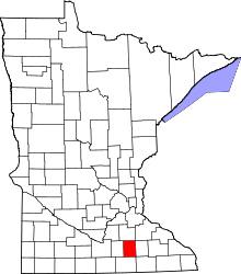 | |
| Townships | ||
| Unincorporated communities | ||
| Ghost town | ||
| Footnotes | ‡This populated place also has portions in an adjacent county or counties | |
Coordinates: 43°52′00″N 93°03′04″W / 43.86667°N 93.05111°W